

Because I want to keep this datafield and the app free for use I would be very grateful about a small donation to PayPal
A detailed description of how to use it can be found here:
HMs_DIY_GUIDANCE.pdf
HMs_DIY_ANLEITUNG.pdf
Thanks very much to mcinner1 for putting so much time into this documentation!
You can contribute on my github page.
You can upload your layout so others can use it as well.
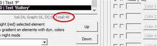
Also any changes to the fonts.txt can be updated there as well.
=======================================================================
RELEASE NOTES
=======================================================================
-----------------------------------------------------------------------
3.8.3
* fixed problem with backslash in configuration string
-----------------------------------------------------------------------
3.8.1
* switched to new SDK 8.3.0
* added devices: Approach S50, D2 Mach 2, Descent G2, Edge 550, Edge 850, Edge MTB, eTrex Touch, fēnix 8 Pro 47mm / 51mm / MicroLED, Forerunner 970, Forerunner 570 42mm, Forerunner 570 47mm,
GPSMAP H1, Instinct 3 AMOLED 45mm, Instinct 3 AMOLED 50mm, Instinct 3 Solar 45mm / 50mm, Instinct Crossover AMOLED, Instinct E 40mm, Instinct E 45mm, Venu 4 41mm, Venu 4 45mm / D2 Air X15, Venu X1, vívoactive 6
for full releasenotes see: releasenotes.txt
=======================================================================


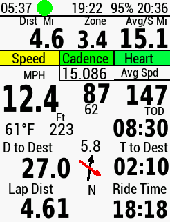 Note top left, I have only rode 4.6 miles on bendy rodes (Top Left), but the "
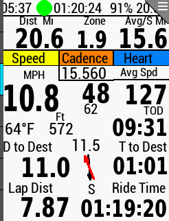 At the point where I head for home, 11 miles following the course but 11.5 miles as the crow flies in a straight line.
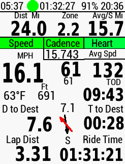 Closer to home, things look better, "Distance to Coordinate" is less than "Distance to Destination" as it should be, but I have a big dog leg of about a mile to the West to come.
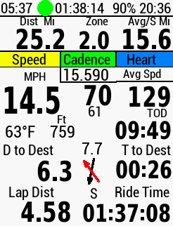 I am now doing the dog leg to the West, but the "Distance to Coordinate" is now 1.5 miles greater than Distance to Destination, How, that should be impossible????
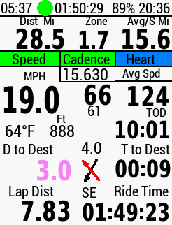 Three miles from home following the course, but "Distance to Coordinate" showing 4 miles as the crow flies
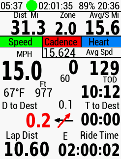 And finally as I am about home, it is correct, my start location is just to my right in the next street after I do a short U turn from the street I am in at present.
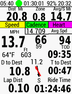 Note the 11.2 above the two arrows which is the distance to the start location, but its only 10.8 following the course, an impossibility.
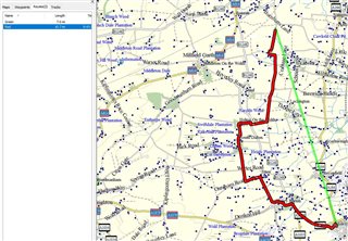 But, when I go into Garmin mapsource, I find if I convert 11.2 KM (suposedly miles) into miles it comes to just over 7 miles and that is the exact distance (Green Route) from the screenshot location to the Start Location. There is a slight error in my screenshot of mapsource but that is because it was just a quick rough attempt at getting the exact positions.