
This problem was allready reported in the beta version by different users.
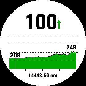
The scale should be 14443 m or 14.4 km
Fenix 6X Sapphire
This problem was allready reported in the beta version by different users.
The scale should be 14443 m or 14.4 km
Fenix 6X Sapphire

Why ? Isn't that obvious. They don't care. There can not be any other explanation.
Please be nice in our forums. If you personally knew the engineers, saw the hours they work, and…
The issue is resolved with the v25.00 software update.

https://forums.garmin.com/members/af7e41af518b479984b3757ab539b01f
You seem to be a good guy, anyway, G-Chris. It is not your fault what the general outcome of all these issues are.
And frankly speaking…

