EDGE MapFields

IQ Store Link

New device: EDGE 1050 !

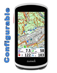
Edge Mapfields is meant for use with the mapscreen on your device.
There are 4 fields, which every field can set with many options (see below).
It's created for Edge 1030, 1040, 1050, 530 and 830, 540, 840 and Explore and Explore2

This datafield is free of charge, but if you like it and use it, it would be nice to be invited to a beer: paypal.me/AndreasWirth

After installing the datafield on your device, place a full-width field under the map. In this field you put the EdgeMapsFields.

In the setup you can choose a display for each quadrant from many different options:
see:
https://apps.garmin.com/apps/30fdcbb5-a0f2-4832-9157-b7dcd81e7a0f

Both metric and statute format!

Time to Destination is calculated by your average speed. In the beginning - when no average speed is available - Time to Dest. is calculated by 10 km/h ( 6.214 mi/h).

Timer format is mm:ss for time less than one hour, and h:mm for time more than one hour.

Of course you can use this datafield on every screen with a datafield of 1/5 of the screen height.

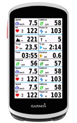
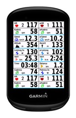
Note: the pictures below are photoshoped to show all options on one picture.
You can only set one datafield on your device!


  • Thanks for the Information about the disavailability of  Edge Mapfield #1.
    I tried to change the configuration of my #1 in vain since days, before I found this article.

    Donuts will be sent ;-)


  • Donuts have arrived! Thanks!

  • The datafield is back on the EU store!

  • Attention!

    I have to remove the option „Average Power for Minutes“. 

    If this option is important to you and does not cause any problems, then do not update - at least for the clone you are using.
    There will hardly be any more updates anyway, as this data field is maxed out in terms of memory.

  • Hey McInner1,

    Love the data field. Quite helpful, indeed. Would it be possible to add 'Ascent Remaining' to the data collection?

    In case this activity would be best accompanied by delicious coffee or some lovely donuts please feel encouraged to send me the PayPal link.

    Best

  • When I choose Anstieg and Abstieg in one Field (2 Datafields only) I get only „Problem / Double“ on my 1050. 

  • Hi, excellent data field.

    I used your slope/grade field for a recent road ride in the Alps. I combine the field with ClimbPro, and I noticed that there was a substantial difference in the slope reported by ClimbPro and the slope reported by your data field. I feel that your field usually reported around twice the value that ClimbPro suggested. 

    I'm not particularly impressed by the ClimbPro elevation profile though (is there a way to improve these??), so I'm not suggesting something is wrong with your values. I will however say that your data field frequently suggested something like 25% gradients, which I feel is very high. Perhaps a longer averaging length/time might provide more realistic values?

    Best,

    Fred

  • Would it be possible to add 'Ascent Remaining' to the data collection?

    Sorry for the delayed answer:
    This metric is not available in the IQ SDK and it cannot be calculated!

  • When I choose Anstieg and Abstieg in one Field (2 Datafields only) I get only „Problem / Double“ on my 1050.

    Sorry again for delayed answer:
    I have to check on my device to see what‘s going on…

    As an idea: if you use only 2 visible option fields - the not shown right option fields must be another choice than the visible ones!

  • I used your slope/grade field for a recent road ride in the Alps.

    A) Climb pro:
    A distinction must be made between the gradient shown in the small box and the graph with the color-coded gradients. For freeclimbs (without loading a course) the graph shows the elevation out of the DEM map, whereas for loaded courses the elevation shows the loaded elevation from the course file.
    I assume, you mean the gradient shown in the little box at the current position.
    This gradient has not really to do with ClimbPro. It is simply the Gradient that would also be shown in the Garmin‘s native datafield Gradient.

    B) my gradient:
    I ride only MTB and I never have seen 25%. It is the maximum/minimum value that can be shown. The averaging sample is fixed to 12 seconds in MapFields, which I found out is the optimum stability vs. delay. So, I‘m a little confused about your observations, and I really don’t know what has happened…
    Especially for road riding - where you ride much faster than MTB - it is a mystery.

    And - as you stated - the gradient is one of the difficultest calculation and you will never get a solid correct and fast reading…