This discussion has been locked.
You can no longer post new replies to this discussion. If you have a question you can start a new discussion

Is my Edge getting confused when navigating a route?? See pics

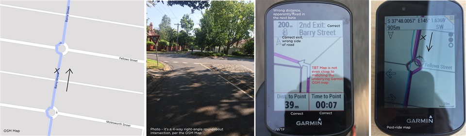
I'm having a lot of problems navigating with my Garmin Edge 530, since I purchased the unit about 6 months ago.  I'm in Australia, and i have an Australian-delivered unit.  I had another terrible experience on the weekend and decided to try to figure out what was going wrong.

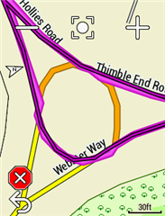
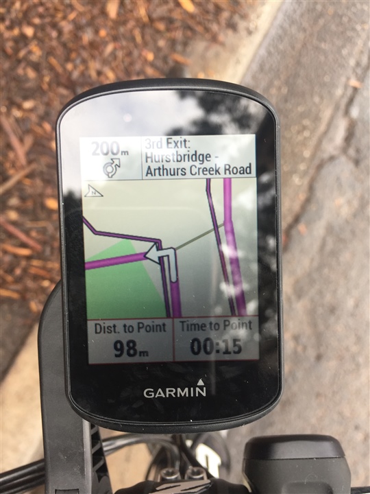
Here is a picture of the Edge 530 when I'm approaching a roundabout. The gpx route is to turn to the right. 

The roundabout icon on the top left of screen shows the exit in the correct direction, but it is suggesting i ride around the right side of the roundabout (wrong for Australia). 

The 3rd exit is correct for riding around the left side of the roundabout. And the name of the road to follow is correct.  So the top right of the screen works.

The arrow on the map says to turn left which is completely wrong.  I followed the arrow, and shortly after the unit told me i was off course. The map does not look anything like the OSM open street map on which the Garmin map is based.

(also not sure why i have 2 different distance markers, the lower one 98m is correct)


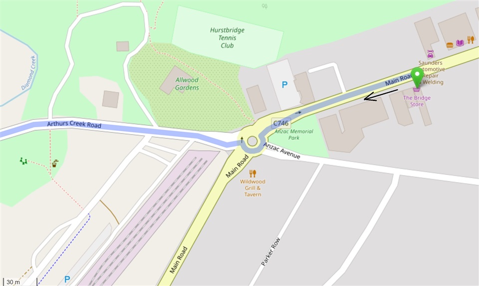
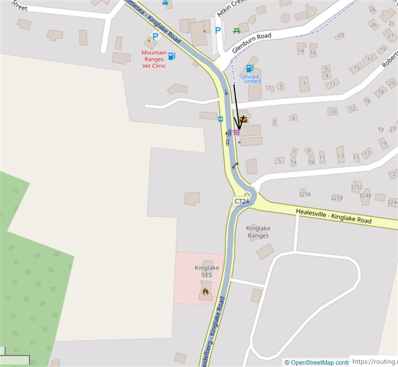
OSM shows the correct Australian navigation around the roundabout. - openstreetmap.org

I'm about 100m from the roundabout.

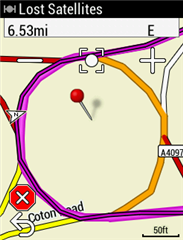
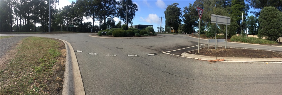
Here is a second example.  The route per the gpx is the right hand turn.  See description with each picture below.  Can anyone explain what is happening with my unit?  I would be very grateful, thanks.

The OSM direction around the roundabout is correct for Australia

The roundabout icon at the top left of the Edge 530 is indicating the wrong direction this time.  It also says to go around the right hand side of the roundabout, also wrong. 

At the top right it says to take the 3rd exit, which is correct for going the correct way around the left side of the roundabout.  The street name to exit on is also correct out of the 4 uniquely named streets!  So the top right of the screen works again. 

The Edge 530 map again does not look like the OSM map.  You can see there are not any streets on the Edge 530 map approaching from the north, as indicated by the north pointer on the screen.  But as you can see from the OSM map the approach is almost directly from the north (page orientation).


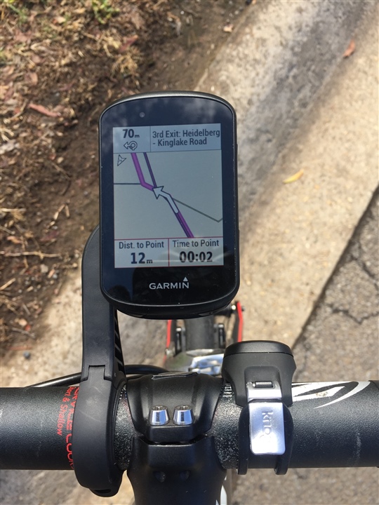
The distance of 70m is wrong and 12m is correct.

So I am at a loss as to how to solve this. Based on these two examples I feel that

  • the top left roundabout icon has some form of American configuration,
  • the top right of the Nav screen works for Australia as intended,
  • the map shown is not related to the intersection being approached, and
  • the arrow direction on the map is getting confused by the mix of configurations. 

I've contacted the retailer, and I think I'll take the bike out again on a planned route to confirm these theories.

  • I think the tracks look off because I have found that the Garmin maps have a lower resolution, especially on roundabouts.  You can see in the screenshots the roundabout is not very round - there are lots of straight lines.  When I create maps the roundabouts look a lot rounder and that is down to the processing of the OSM data when the map is created.  If the course is created with a map with a higher resolution it won't line up completely with the Garmin map as the Garmin map will not have the bends so well represented.

  • So, what do we need ask Garmin to fix...?

  • Well first of all we need to get them to not have the turn by turn pop up to zoom in ridiculously far.  It never did on my Edge 800.  On that the pop up map always zoomed to a sensible level to see the whole junction clearly.  As this has worked before they should be able to sort that out.

    I have examples of it too.  Below you can just see there is another thick white turn arrow disappearing of the top of the map.  The map should zoom to show both turns.

    Not a helpful roundabout view. Where is exit 2?

    Sometimes it works fine!

    @dpawlyk

    The track not matching the route is just because of a far too high zoom level and the resolution of the map vs the track.  Here are examples of the same junctions with the Garmin map and one I created myself.  The tracks were created in RideWithGPS using OSM maps.

    Next it would be good if roundabouts were sorted.  In the UK they aren't even tagged as roundabouts on the map.  Imagine approaching a roundabout and being told to turn left/right when you expect to be told which exit to take.  Rather confusing!

    Roundabout using the Garmin maps - no roundabout navigation

    Roundabout using maps where they are properly tagged as roundabouts - roundabout directions

    I have not had any issue with roundabouts on my Garmin car sat nav unit.

    While I am at it I would love it if you would not get routed paths marked as not to be used as bicycles in the OSM map.  If you use the same map in Basecamp and the bicycle routing option you will not get routed down paths marked as bicycle=no.  On the Edge unit you can get routed down these paths.  It is the same map so it is down to the unit ignoring the bicycle=no tag.

    This causes confusion at junctions when the if there are mapped pavements/sidewalks around it as the Edge unit will navigate you onto these paths to go around the junction instead of navigating you on the roads.  This is using the Road profile.  I get around it by creating my own maps and stripping out all paths marked as bicycle=no.

  • - The current version of the AUS/NZ map is 2019.20. Does this same issue occur if you update to that version of the map?

  • Hi Matthew, thanks for your interest in this topic.

    Based on these faults and my overall experience with the Edge 530, last month I returned my device to the retailer for a full refund.  This was my first Garmin device and I really wanted to like it, but unfortunately its miles behind best navigation (e.g. google/waze), has the pixel resolution of my old Nokia E52 of ten years ago, and has enough bugs to have withheld release for another two years.

    I'm not some crazy dude but I do have high expectations.  I think if if your Garmin bosses are serious about retaining a decent share of the bike computer market then it's time for them to:

    • Double the pixels per inch
    • Imitate google maps for navigation
    • Implement a new product testing and issue resolution process for 95% fewer bugs at time of release (i/e 1/20th).

    Some questions on behalf of other users fwiw:

    Is there any reason for the turn by turn pop-up map zoom level to have changed with the AUS/NX 2019.20 map update?  

    Or for the roundabout icon at the top left to have corrected to riding on the left side of the road?

    Do we need to pay to update the map?  After a quick google I can only find the AUS/NZ cycle map update here https://buy.garmin.com/en-AU/AU/p/567280#overview, for A$28.54, and it doesn't even say which version it is.

  • PPI: More pixels per inch means faster battery drain.  Everyone wants a longer battery life.  It would look nice but the displays as they are are perfectly clear.

    Imitaing Google Maps: You would need much more processing power like Google has.  This would reduce battery life and increase the cost of the unit.

    The roundabout icon will be a generic one.  I don't mind it being the wrong way round for countries that drive on the right.  As most countries drive on the left it probably isn't worth the effort to add a different icon to show up depending on location.

    Garmin map updates of the map the device came with are free.  You only have to pay for Garmin maps if you want one of a different region.  As there are freely available maps of the entire world you don't need to pay for any map.  I don't use the Garmin maps as they a broken in relation to roundabouts for me.

    The turn by turn zoom issue is a bug.  I hope it gets fixed.  It didn't happen with the Edge 800 and it won't be map specific as it happens with the Garmin maps and 3rd party maps.

  • That’s probably what Bill Gates said about Microsoft’s mobile phones

  • "I'm not some crazy dude but I do have high expectations."

    Your expectations might not be realistic. These devices require all sorts of compromises.

    * Google/Waze is doing much of the calculation not on your phone (meaning the phone itself isn't sufficient).

    * Google/Waze really requires near-constant internet connection. This means the device can't really be used outside of cell network access.

    * It's easier to do route navigation for cars. Most drivers are only interested in the fastest/shortest distance. Google maps doesn't support the "follow a track" feature that is commonly used on these devices.

    * The 530 is very small. Much, much smaller than any smartphone. That means the thing that uses the battery is very power limited. One thing that means is being slow.

    * Most phones doing continual navigation either can't do it for very long or have to be plugged in (that's with a much larger battery!).

    * The newer Garmin devices are an evolution of earlier products. This, unfortunately, means they really can't add every feature people want. The alternative is to rewrite the software to work on a new architecture. The investment to do that might not be worth while.

    =============

    it does appear you might be having a few relatively easy-to-fix problems (problems that don't seem to happen on other units or software versions).

  • Melbourne here - was riding in the Boronia, Ferntree Gully area and noticed the roundabouts are no longer displayed as roundabouts in my 530.....lucky the TBT instructions was still correct....it made for a confusing ride headning into the roundabout. This was on the standard Garmin AU Cycling map. What gives - is there really a problem with roundabouts being displayed with the 530????

    Would the OSM maps be better in displaying roundabouts??

  • In the UK roundabouts appear not be be marked as roundabouts on the Garmin map even though they are correctly marked in OSM.  It could be the same in Australia.  A third party map would probably have roundabouts correctly marked in the map.  It is nothing to do with the device itself, it is down to the maps.