This discussion has been locked.
You can no longer post new replies to this discussion. If you have a question you can start a new discussion

Is my Edge getting confused when navigating a route?? See pics

I'm having a lot of problems navigating with my Garmin Edge 530, since I purchased the unit about 6 months ago.  I'm in Australia, and i have an Australian-delivered unit.  I had another terrible experience on the weekend and decided to try to figure out what was going wrong.

Here is a picture of the Edge 530 when I'm approaching a roundabout. The gpx route is to turn to the right. 

The roundabout icon on the top left of screen shows the exit in the correct direction, but it is suggesting i ride around the right side of the roundabout (wrong for Australia). 

The 3rd exit is correct for riding around the left side of the roundabout. And the name of the road to follow is correct.  So the top right of the screen works.

The arrow on the map says to turn left which is completely wrong.  I followed the arrow, and shortly after the unit told me i was off course. The map does not look anything like the OSM open street map on which the Garmin map is based.

(also not sure why i have 2 different distance markers, the lower one 98m is correct)


OSM shows the correct Australian navigation around the roundabout. - openstreetmap.org
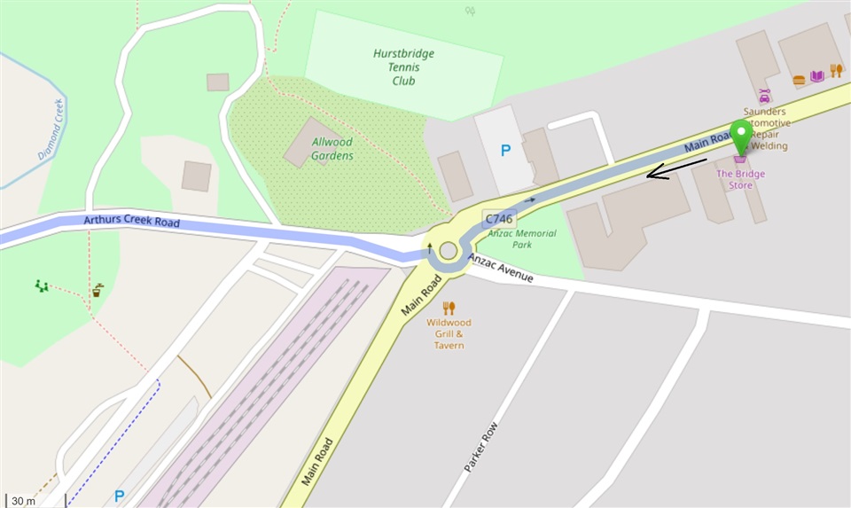
I'm about 100m from the roundabout.

Here is a second example.  The route per the gpx is the right hand turn.  See description with each picture below.  Can anyone explain what is happening with my unit?  I would be very grateful, thanks.

The OSM direction around the roundabout is correct for Australia
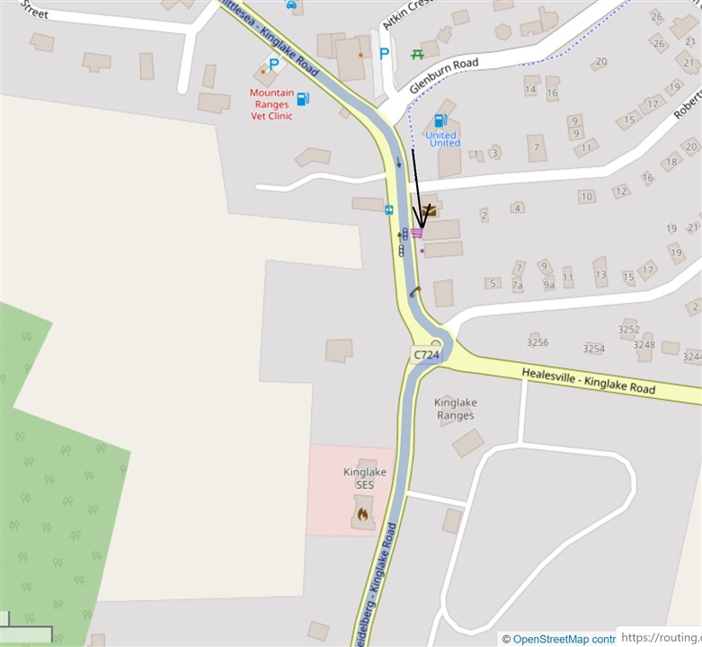
The roundabout icon at the top left of the Edge 530 is indicating the wrong direction this time.  It also says to go around the right hand side of the roundabout, also wrong. 

At the top right it says to take the 3rd exit, which is correct for going the correct way around the left side of the roundabout.  The street name to exit on is also correct out of the 4 uniquely named streets!  So the top right of the screen works again. 

The Edge 530 map again does not look like the OSM map.  You can see there are not any streets on the Edge 530 map approaching from the north, as indicated by the north pointer on the screen.  But as you can see from the OSM map the approach is almost directly from the north (page orientation).


The distance of 70m is wrong and 12m is correct.

So I am at a loss as to how to solve this. Based on these two examples I feel that

  • the top left roundabout icon has some form of American configuration,
  • the top right of the Nav screen works for Australia as intended,
  • the map shown is not related to the intersection being approached, and
  • the arrow direction on the map is getting confused by the mix of configurations. 

I've contacted the retailer, and I think I'll take the bike out again on a planned route to confirm these theories.

  • I think three topics might relevant:

    First, the distances 200m vs. 98m and 70m vs. 12m are not aligned (no update of the distance at the top during approach). I think this is corrected in a new firmware version (current beta?).

    Second, I assume you ride on the left side of the street (Australia), correct?

    Third, I have similar experience of getting confused by the Edge. I assume it wants to advise you to turn left into the roundabout (which should be correct as first step). The issue is that the displayed map is in  very (!) large scale which is not very comprehensive. This happens to me often when the Edge wants me, for example, to switch from the roadway to a cycleway in parallel to the roadway ("turn right, then left" map). Then, the map is displayed in such a large scale that I assume I should really make a turn. A workaround for me is to manually choose the map view to be displayed, which does not change the scale.

    But I am not sure if this is the explanation!

  • I would double check the roundabout in OSM to see if it goes the correct direction there.  If it is correct in OSM then it is likely an error on Garmin's part when they made the map form the OSM data.  Roundabouts in the Garmin map in the UK have issues as well so it could be down to which side of the road you drive on.

  • Yes we ride/drive on the left.  I checked both roundabouts in OSM, and they are both correct for Australia, I've updated the above with this info. 

    Is it possible that my device has reverted to some form of American settings?

  • The side of the road you drive on is set in the maps.  If it is wrong for your country the roundabouts will navigate the wrong way.  There is no setting on the device for this.

    Try third party OSM based maps for your area and see if they work properly. If they do then why not use them instead?

    I create my own maps for my Garmin units so I am familiar with how you need to set which side of the road you drive on during the process to get navigation to be correct at roundabouts.

  • If the side of the road is purely map-based, then I must have a USA-based map system/config/driver or whatever in my device.  The reason I purchased an Australian-delivered Edge 530 was to avoid issues like this.  The Edge are designed to work in Australia, and should not to give conflicting nav info at each intersection. 

    The retailer has offered for me to return the device.  So I'll need to decide whether I'm silly enough to see if another Edge works properly, or switch to a competitor

  • It's still my impression that the confusing navigation prompts could result from an unadequate map scale.

    So before taking your decision, it might me worth to consider the following steps:

    - Install the latest beta firmware (see here). This should at least cause the distance to the turn shown in the top field to update.

    - Try to ride along the affected road with activated navigation and the "map" screen displayed on your Edge (in an adequate scale) to check if the map and is shown correctly in this case (when no navigation prompts occur). (Or configure the navigation prompts to text only instead of showing the map.)

    - Try to switch of "auto-zoom" in the navigation setting of the affected activity profile and select an adequate map scale for the navigation prompts. You could also try to zoom out when a confusing navigation prompt is displayed.

  • If other roundabouts work properly then the side of the road is set correctly in the map and there is a glitch at this particular junction (maybe there was an OSM error when the Garmin map was compiled).

    It is a good idea that the side of the road you drive on is baked into the maps as then you can use it in other countries with suitable maps and not have to remember to change a setting on the device to set the driving direction.

    If this issue is caused by a map issue then every device using the maps will have the same behaviour.  It is silly to return a perfectly working device because of a possible map problem.

    Try a different map and see if the issue occurs then (remember to disable the Garmin map if you try a different map).  There are freely available maps for Garmin units for the whole planet.  Many people prefer non Garmin maps for various reasons.  You don't have to use the Garmin maps and they are not necessarily superior.

    Personally I don't particularly like the Garmin maps which is why I create my own so I can customise what features are included and have my preferred colour scheme.

  • Is it the TBT ‘pop up’ that’s wrong?

    if so, this happens/happened to me, especially so on some roundabouts.

    if you close the pop up, the map screen is totally different (and correct). For me at least, the light pink line on the pop up doesn’t look anything like the pink lines on the map screen :-S

    to me it seems that the TBT pop up gets confused sometimes and tells you to do something totally bonkers.

    It used to happen on my 810 sometimes, but actually cause the unit to crash.

    i can’t believe it isn’t fixed, and ended up selling my 830 because of this bug and a few others.

    not good enough.

  • The darker "purple" line is your track. It doesn't appear to be following the roads on the map installed on the device. The device calculates a second "path" (the light magenta line) that follows the roads in the map installed on the device. Ideally, these two paths would be in the same place (it doesn't have to be exact but it can't be too different).

    It doesn't seem the map used to create the route matches the map installed on the device.

    Do you have the detailed map enabled on the device?

    Where did you get the course (track)?

  • Gary+Bray yes exactly its the Turn By Turn pop-up that is wrong!  You got me thinking and I went back to the map of my completed ride on the Garmin, and zoomed in on the examples above.  The Garmin road map matches the OSM map perfectly.  So it is purely the TBT directions that do not match the map or road.

    Which bike computer did you switch to when you sold your Edge 830? If you're happier with your new device I will probably give it a look.  I think this has solved my question about whether to try a new Edge 530.

    Wongataa / dpawlyk - yes you're practically right in that the map used to create the turn by turn directions does not match the map displayed on the device's map screens.  I used strava routes to build the gpx.

    I have 3 enabled maps - Worldwide DEM Basemap NR, Garmin Cycle Map AUS/NZ 2018.20, Garmin DEM Map AUS/NZ 2017.20.  Should I disable the Worldwide DEM and 2017 AUS/NZ DEM?

    Is it possible that turn by turn directions are being fed from an inferior currently-enabled map such as the Worldwide DEM Basemap?

    Example 2: Matches OSM map but not TBT map