This discussion has been locked.
You can no longer post new replies to this discussion. If you have a question you can start a new discussion

Elevation chart and grade display completely wrong on 530 with v 3.50.0.0

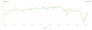
My 530 was displaying grade during the ride accurately and had accurate elevation charts in Garmin connect after the ride.  That all changed last week.  The grade seems totally random. For example, today it indicated -7% during a steep climb.

In addition, the elevation chart displayed after a ride is completely wrong.

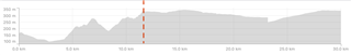
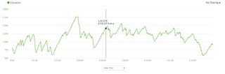
This is what it showed on my ride today before I applied elevation correction.

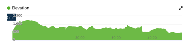
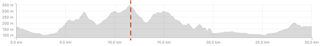
Here's the same ride after elevation correction was applied.

As you can see, they are completely different.

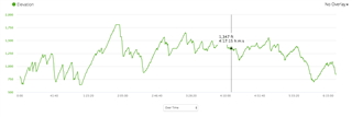
I don't know if this issue started when 3.50 was applied.  Anyone else having this problem?  

  • Only purchased 530 in last 3 weeks, running with 4.10 installed. I am also using Fenix 5x to record ride. The 5x readings during the ride are pretty accurate (I did a ride today that I do several times most weeks, so I know climbs / route etc pretty well), but the elevation readings and the climb gradients on the 530 were laughable. I used it in two different "modes", part following a preloaded route, part not doing so and it made no difference. At one point I remained stationary and monitored what the unit was doing and over a 2-minute period (whilst stationary) the elevation reading went from -926 ft to -1155 ft. At the end of a ride which had a total Ascent of 248m and Descent of 247m (as recorded by the Fenix 5x) whilst the 530 recorded an Elevation of -7,143 ft. Very strange for a ride in the middle of the New Forest! Interestingly on Garmin Connect at the end of the rides, the 530 readings were adjusted to Elevation Gain 256m and Loss 235m, but Min Elevation of -500m, Max Elevation of -211m, neither of which reflected what the 530 was showing during the ride.

    Additionally, a lot of the climbs (mainly shallow runs around here of up to 6%), read as descents. The only exception to this is a sharp hill about 200m long which has a gradient of 16-17%, the advance notice was that it was a 4% climb, but on the climb itself, the "Climb Pro" feature changed to 7%. Still well adrift, but it was the only time it acknowledged an ascent! However, even whilst climbing this, the elevation count was still going the wrong way.

    The mapping was showing the position correctly, so the GPS was working correctly. The maps are the ones that came with the unit. I have reset the unit once, and this has had no affect, so I'm really at a loss here. There are a few other issues, but these are minor in comparison.  I am a loyal Garmin user of many years, and my bike is awash with Garmin, but this unit (which I purchased to upgrade from my 810) is of little use if this continues. I am in the fortunate position that here in the New Forest I am not far from Garmin's Southampton HQ, but also this coming Friday, there is the Garmin Ride Out taking place only 1.5 miles from where I live. I normally participate, but not this year, but I will be going along with the unit to seek some answers. I will post them here.

  • My 830 was fine when new but the last few weeks is has been completely out by at least 200m (less). Same local climb of around 1000m for the last 5 years and it records 800m and this is for all my local mountain road bike climbing. I live and start rides at 413m, the Garmin is correct and even when I manually calibrate it has me finishing at 500-600. I have to do a elavation correction in Garmin connect and Strava after every ride now. The Gradient is completely screwed and out. I will be on a 10% and it will say 4% and on the flat it could say - 11%..

  • would you please look at this thread and register this as a bug for future SW fixes?

    (if it is software related, that is)

  • Chiming in to say I am experiencing the same problems with my Edge 530. (Starting and ending at the same point, known route so I know what the elevation should look like.)

    Before correction:

    After correction:

  • We are actively investigating this problem. I will provide an update when I have one available. I apologize for any inconvenience this may have caused.

  • As a workaround you might try to disable auto-suspend on the device. This and not suspending the device manually solved the elevation issues for me.

  • Same problem for me on a 530 running 4.10. 

    Uncorrected elevation profile looked like this:

    Corrected profile looked like this:

    Uncorrected profile from my Fenix 3 (missing a couple of miles) looked like this:

  • I called Garmin customer services (Switzerland) in the end and within 5minutes they emailed a return form to send the 830 back. Within 3 days of sending it a new fully boxed one arrived, I have only tried it once with some proper elevation but that was ok. It recorded 1286m and correction comes out at 1315m - the other club members I rode with were showing 1280/1300m using other Garmins, Wahoo and smartphones. So far so good but as my original 830 was fine for the first 2 months only time will tell on this second device. 

  • My 530 just started this as well. I bet i have 10, maybe 15 rides with it as it is brand new. Every ride has been perfect until I updated and boom... elevation is completely incorrect. Here are some examples of the exact same loop before and after the update. I have had the worst luck with Garmin. I have owned a 510 (Best of them all), a 520 and now the 530. Not to mention 2 watches and other Vivo devices. I think its time to go Wahoo for me. Please tell me you can fix this Garmin. I would hate to have to move/recreate the last 5 years of data on another platform!

    Before...                                                                                         After....


  • I experienced the same issue, did the same exact route Saturday as I did back in August, elevation from that ride was 1278, yesterday it was under 1100, when I corrected it in Garmin it updated to 1,195 , using the Strava correction it shows 1235. The amount of bugs I have encountered while using this device is mind boggling.