Bluefish, thought I'd continue the discussion here.
There does seem to be an element of elevation smoothing adding to this
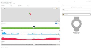
Using Garmin Basecamp to compare the FIT and GPX

Bluefish, thought I'd continue the discussion here.
There does seem to be an element of elevation smoothing adding to this
Using Garmin Basecamp to compare the FIT and GPX
GPX file is GPS plots, FIT file is GPS plots plus Garmin magic. If you have good GPS signal and Garmin magic is on your side - distances will be same or difference will be very small.
If GPS signal is…
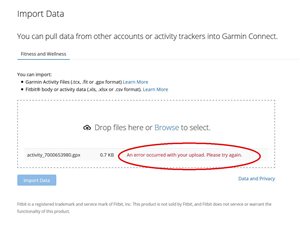
If GC sends the GPX file to Strava why then do I rarely see any difference in distance?
Like you I’m not seeing it. I think strava gets a FIT file but I’d happily be corrected…
Fit file says![]()
Gpx says![]()