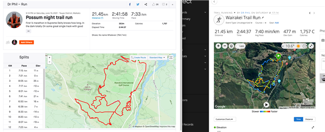
Bluefish, thought I'd continue the discussion here.
There does seem to be an element of elevation smoothing adding to this
Using Garmin Basecamp to compare the FIT and GPX

Bluefish, thought I'd continue the discussion here.
There does seem to be an element of elevation smoothing adding to this
Using Garmin Basecamp to compare the FIT and GPX

GPX file is GPS plots, FIT file is GPS plots plus Garmin magic. If you have good GPS signal and Garmin magic is on your side - distances will be same or difference will be very small.
If GPS signal is…
If GC sends the GPX file to Strava why then do I rarely see any difference in distance?
Like you I’m not seeing it. I think strava gets a FIT file but I’d happily be corrected…
Fit file says![]()
Gpx says![]()
Yeah, you are now in maths territory!
You take the GPS data, the accelerometer data and try to piece it all together tore-create the run you did. I will be honest, after doing data-processing myself - I wouldnt envy the job.
I THINK (and again I must stress THINK) that the way the Fenix does it is tailored to low battery usage - as the watch comes from an ultra/endurance background so all processing is going to be mindful of battery. You see all manufacturers possibly have their own way of doing it. Some works well for some, others work well for others.
Me - for example. I prefer long distance running - so Im no sprinter, and my short runs are 6K at the lower limit - and in the week I do up to 30K a run. I don't see much issue with instant pace many because I don't run to it. I run to HR zone, and lap pace over each km.
I wonder if (for example) the forerunner series are possibly more tailored to more generic running...
This could all be nonsense of course!

Ok please excuse the crappy diagram - I am a terrible artist
The green curved line is the actual earth's surface. The red line is the path the person takes (this is side on so its height up and down) and the blue crosses are the 1 second readings where the watch takes a position. It then calculates distance from the blue crosses by joining them by a line. This is basically how the GPS reading works.
Now below the yellow line is the DEM model for that surface - it's coarser, and so the blue positions now are sampled not using GPS height, but only GPS position and then each blue cross is FIXED to the yellow surface (which I didn't draw just for clarity) and the distance is then again plotted fro, the blue line. Over time, these two can change significantly.
Below that is a real extreme example the blue curly light is a very up-and-down terrain but the red line below is the coarse DEM model of it's height.
DISCLAIMER: This is what I suspect is happening. May have no bearing on reality!
If GC sends the GPX file to Strava why then do I rarely see any difference in distance? What I do see quite often is a difference in the time between the two (and hence overall pace) because Strava removes stopped time. In this case because I stopped for a couple of minutes to remove a rain jacket.
No this not an exception! For me it's the rule,

Where and how would I do thst? I live in a flat area. The biggest elevation is about 6m over 400m and the rest is beliw 1m
Do what, sorry?
What I’m wondering is that if some of this discrepancy people are seeing between FIT and GPX is DEM related.
Like you I’m not seeing it. I think strava gets a FIT file but I’d happily be corrected there. I wonder if like me, you live in a well covered area for DEM
Even in flattish areas, over a distance these positional errors could mount up if the underlying DEM is coarse.
must admit this is conjecture, but I’m basing this on a diffferent ascent and descent seen between GPX and FIT and trying to identify why.
Personally, I’d take the one using GPS elevation as statistically more likely to give accurate ascent/descent and this would roll over into distance.
Out of interest, those seeing this discrepancy…does altering “elevation corrections” setting for the activity do much?
Yes,
did a quick comparison on my usual 10.633 km course.
See my reply on your other thread. With EC on you’re locking your activity to the same DEM underlying the map as the route you plot. That’s vIOU’s for them to nearly totally agree, except for some x,y wobble.