Bad Elevation Tracking in Ski AND BC Ski (updated) RC 16.00

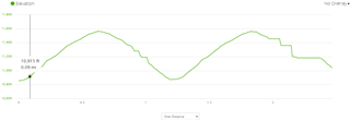
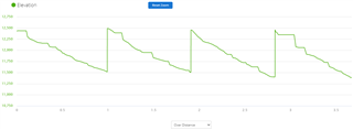
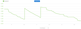
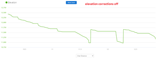
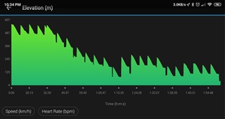
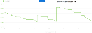
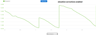
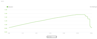
I'm still seeing huge misses on elevation with the backcountry ski activity. Usually this happens on the way up, but today it happened on the way down. It registers zero descent and then suddenly corrects, creating plateaus and cliffs in the graph. There are plenty of (accurate) GPS data points in that portion of the activity that follow my track closely, but the elevation registers no change for a long time.

Notes:

  • Altimeter > Auto Cal > During Activity > Continuous
  • Baro Watch Mode set to "Auto"
  • The watch is covered by a glove and wind is definitely not impinging the barometer port.
  • The runs vary from 20 to 45 mph and it happens seemingly at all speeds
  • SW is v16.00 RC
  • Tried again, the bug persists:

    It's possible this is because I'm pausing and resuming the activity at the top, but the GPS trace is flawless and for the altimeter to be this erroneous is very suspicious. Maybe it's not handling rapid decreases in elevation (skiing) properly.

  • Error is reproducible in Ski activity, and shows up over dozens of runs, with grossly incorrect elevation profiles at all times. GPS remains accurate and turning elevation corrections on (using terrain elevation map and throwing out the watch's elevation data) shows a vastly different profile

    Compare these two images without and with elevation corrections on:

    In order to give such a smooth curve with elevation corrections on, the GPS has lots of data points to check against the terrain map. This is definitely not a GPS error, it's an altimeter/auto cal error. My guess is that the altimeter was not adequately tested with the higher speeds and rapid elevation changes that are seen in skiing, so it throws out the data and only updates against the DEM when stopped or at longer intervals.

  • Unfortunately, the altimeter on this watch is an unmitigated disaster. There are dozens threads where similar issues are reported. Garmin simply does not care.

    Just for fun, try and wear it on the right wrist. For some people, this helps.

  • I hate to think you might be right about this, but it does seem like they aren't even attempting to fix some major bugs. I want to point out that this is very different from the bug people seem to get where lefties (or right-wrist wearers) get sweat in the baro port and it screws up altimeter readings. This is totally different. The watch couldn't be drier, and the port is completely sheltered from wind under a sleeve or glove gauntlet.

    The altimeter (and other features) needs some serious context-specific code to reject bad data. I think when skiing 20+mph and dropping hundreds of feet in a minute, the code is trying to filter out a pressure spike like it's a transient change in hyper-local baro, like a gust of wind causing a pressure spike on a windy city block or canyon ridge. This is probably sensible for walking, hiking, or trail running, but it's just total nonsense for skiing. What's worse, there's an internal Digital Elevation Map (DEM) to sanity-check baro changes against. Why does altimeter auto cal not handle this circumstance elegantly?

    If Garmin is going to have native features like ski and backcountry ski, they really need to spend some time to make sure the code handles common use scenarios. Most wearers aren't skiing at walking pace and letting the altimeter take its time adjusting to changes.

  • Former Member
    0 Former Member over 4 years ago
    Baro Watch Mode set to "Auto"

    Have you tried taking it out of 'auto' mode and using 'altimeter' mode?  It works well for me snowmobiling.  I've also had better results calibrating the altimeter at the start of activities and turning off auto calibrate during activity. If the GPS is off by 25 feet, elevation will change using DEM for that location.  25' laterally from you could have a 40' drop or 40' rise from a ridge line. 

    Altimeter - The watch is locked in altimeter mode and all changes in pressure will impact the elevation reading. This mode is best for activities with a lot of elevation changes.

  • Former Member
    0 Former Member over 4 years ago in reply to Former Member
    Baro Watch Mode set to "Auto"

    Have you tried taking it out of 'auto' mode and using 'altimeter' mode?  It works well for me snowmobiling.  I've also had better results calibrating the altimeter at the start of activities and turning off auto calibrate during activity. If the GPS is off by 25 feet, elevation will change using DEM for that location.  25' laterally from you could have a 40' drop or 40' rise from a ridge line. 

    Altimeter - The watch is locked in altimeter mode and all changes in pressure will impact the elevation reading. This mode is best for activities with a lot of elevation changes.

    they really need to spend some time to make sure the code handles common use scenarios.

    They do.  You can set the the altimeter calibration and barometer mode that best fits your activity/scenario. 

    support.garmin.com/.../

    support.garmin.com/.../

  • Altimeter - The watch is locked in altimeter mode and all changes in pressure will impact the elevation reading. This mode is best for activities with a lot of elevation changes.

    The problem with altimeter mode the barometer will constantly drift with weather, making your elevation drift, like this:

    From this thread

  • Ok, today I tried with baro watch mode changed from "auto" to "altimeter":

    this is the altimeter output without any terrain-based elevation corrections in Connect:

    now see how the profile is supposed to look with elevation corrections turned on: 

    Baro watch mode has no difference in accuracy during descent, and introduces other problems as far as I can tell, also.

    Let's check out Backcountry Ski with the same settings (altimeter instead of auto). Same problem:

    Again, the GPS is precise enough during this time to even correctly show which side of the run I'm on, with very fine data points. I can even see some of the larger turns I made on the way down. GPS has accurate data, yet the elevation profile is junk.