How to change the colour of 'navigation/course follow line' with your own map theme!

As I've posted in this thread, by the navigation line in my watch changed sometime in the middle of Sept. to a much thinner one that I've trouble seeing with most of my maps: https://forums.garmin.com/outdoor-recreation/outdoor-recreation/f/fenix-6-series/194034/how-to-change-the-colour-of-the-navigation-line

Contacted support, but they didn't have an answer.

I started to test what possibilities with the map theme files and found out that this style field="MPM_ACTV_CRS_CLR" is used for the navigation line.
If you create different map theme files with different colours, you can even change the colour while running depending on the map background.

Create a text file and save with extension 'kmtf' to the map theme folder on watch.

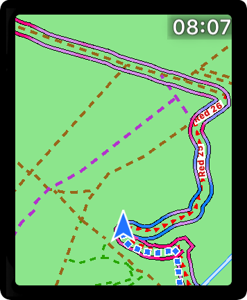
This text give you a dark green line with dark green borders.

<?xml version="1.0" encoding="UTF-8"?>
<garmin_map_theme>
	<metadata>
		<title>DarkGreen</title>
		<description>DarkGreen</description>
	</metadata>
	<stylelist>
		<style field="MPM_ACTV_CRS_CLR">
			<color>
				<primary day="#ff006400" night="#ff006400"/>
				<secondary day="#ff006400" night="#ff006400"/>
			</color>
		</style>
	</stylelist>
</garmin_map_theme>

Great color code page: http://www.farb-tabelle.de/en/table-of-color.htm

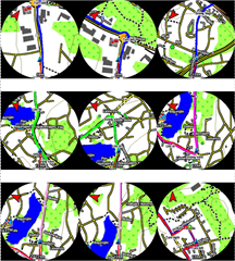
Some examples: Blue, green, magenta and the last-right one are red with blue borders.
The two bottom-left is the thin original that shows up if no theme is used.

  • I could remove the borders of the navigation line, #00ffffff worked, whereas #00000000 leads to black borders, even though both values state full transparency Thinking anyway 

  • Excellent finding. I was trying out the fields "MPM_CRS_ARRW_CLR" and "MPM_CRS_ARRW_OTLN_CLR" yesterday, but obviously, it didn't work.

    Regarding the borders, if you do the borders white, then the line will look thinner, but because they are white they still will cover background.

  • I wanted to give an update. I tried making a copy of the existing High Contrast theme and making a few changes, and the experiment was successful.

    More, specifically I tried changing MPM_UNPAVED_CLR and MPM_TRAIL_CLR field. The first one is for unpaved roads and the second one is for trails.

    <style field="MPM_UNPAVED_CLR"><color><primary day="#ff000000" night="#ff000000"/><secondary day="#ffffffff" night="#ffffffff"/></color></style>
    <style field="MPM_TRAIL_CLR"><color><primary day="#ffff0000" night="#ffff0000"/><secondary day="#ff000000" night="#ff000000"/></color></style>
    

    What I figured out is that the primary and secondary colors are used as alternating colors for dashed lines. By setting the color the same the dashed line will become a solid line, although I didn't see a way to increase the line thickness.

    Also I've realized that having to zeros in the front of the color makes it transparent. For example the secondary color for trails was #00ffffff. With the primary color being red that resulted in trails rendered as red dashed lines.

    Has anyone figured meanings of other fields. Some of them seem self-explanatory, but others are less clear.

    Overall it seems these themes were still designed for car navigation. There are are lot of elements specific to travel by car, like a lot of different styles for major roads and even a separate style for ramps, and styles for vehicle colors. But there aren't as many elements specific for outdoors.

  • Great finding again. Ive been testing the transparency byte from time to time to be able to see through course lune and be able to see paths if they are covered totally.

    Thanks. Maybe soon can have spec with description about many of the styles.

  • Overall it seems these themes were still designed for car navigation. There are are lot of elements specific to travel by car, like a lot of different styles for major roads and even a separate style for ramps, and styles for vehicle colors. But there aren't as many elements specific for outdoors.

    That's why I use OpenTopoMap instead of Garmin maps. 

  • Has anyone had any luck making a theme that displays a hollow route ie a line on either side of the path, road etc that you are following? Simialr to the attached screenshot from another website. 

  • That's why I use OpenTopoMap instead of Garmin maps. 

    Thank you for suggesting that, I live in a rural mountainous area and these maps look WAY better than the default installation. 

  • Has anyone had any luck making a theme that displays a hollow route

    Great idea. Tried a couple of options with  work above with transparency.

    Sorry to say, but I can't get it to work. It's like if the border is a wide line beneath the centerline (primary color) and if the centerline is transparent, the borderline (secondary color) becomes the wide visible line.

  • Thanks very much phoglund, and other's, This is a great upgrade to the watches "courses" navigation feature, depending on my map style,(third party maps) I can also now change my course navigation line to stand out on my chosen map!.... I'm really liking the thick blue line at the moment where I live... Its sooo much easier to see than the standard Garmin line. 

    Send them to Garmin.... maybe they'll be there in a future software update lol... 

    Joking aside, thanks again : -) 

  • Hi! 

    What can I do to increase thickness of all lines in the map. I think they are way too thin... Is it even possible? At least road lines and elevation lines?

    Thank you!