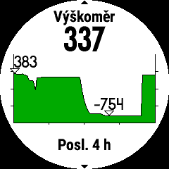
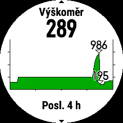
After updating the firmware to version 15.20 I have with my Garmin fenix 5x plus similar problems with altimeter as described HERE. Has anyone noticed a similar problem or I am alone?
What about the auto elevationcalibration at the start of and during outdoor activities? I mean using the gps and dem data for that. Does it work for you?
My automatic altimeter calibration setting is: during activity off, not during the acitivity on. I always calibrate the altitude using DEMbefore the activity. Recording altitude during activity at this setting seems to work correctly, at least for me.
I can try with the setting "during activity on", but it will be on Sunday or Monday at the earliest. If I have time to try it, I'll let you know the result.
let me highlight that in this case any tests make sense only if you avoid the calibrations listed in points 1-3.
Continuous Mode - During activities, the watch uses DEM mapping data, and GPS elevation to offset any altimeter drift due to pressure changes caused by a weather event during an activity. Continuous Mode will allow the watch to calibrate altitude throughout the activity. Note: "At Start" calibration will also occur when Continous Mode is enabled
At Start - The goal of "At Start" calibration is to provide a consistent relative starting elevation for users that do multiple activities at specific locations. It will not calibrate again during the activity. When the timer is started the watch will try to determine the best elevation source to calibrate to, based on the following priority: Click here to view priority list
Manual calibration immediately prior to starting the activity
Prior manual calibration point at the same location
Recent manual calibration, if the quality of the calibration is determined to be good enough
Map data (DEM), if available
Prior Connected DEM point at the same location:
Connected DEM refers to elevation data from the Garmin Connect app on a paired smartphone
Connected DEM, if currently connected to a phone
Prior GPS point at the same location
GPS, if a good fix has been acquired:
After acquiring a GPS fix the timer ring will turn yellow. At that point, it can take up to 30 seconds for the GPS elevation to settle. If vertical speed settles to less than .1 m/s the GPS elevation data will be considered good enough use for altimeter calibration.
Before starting the timer, the elevation data field on the watch will preview the calibrated elevation
Off - The watch will not perform any calibration during or at the start of the activity.