GPS about 30m off

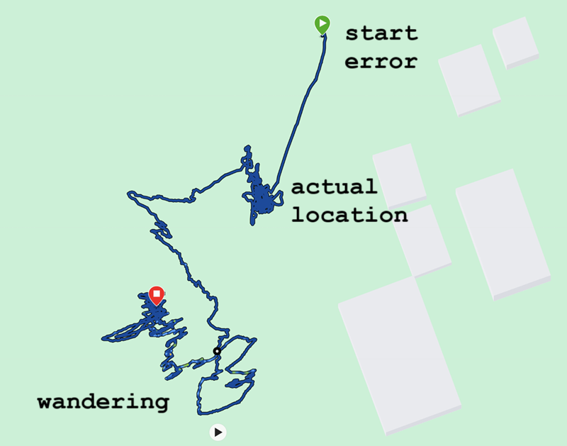
I have noticed this twice now. After using my GPSmap 67i for a few hours the gps is at once way off.

We went for a little walk this evening to find a cache. The gps worked fine until the last waypoint. We were on the right spot and according to the gps we were 30m away from that waypoint.

In the hurry of that moment I didn't notice the fault right away, but being home in my backyard I see the gps is still way off.

Multi-GNSS is selected and Multi-Band is on. According to the Satellite page  there could be a variation of 1.8m. On the map I can see the gps is at least 30m off.

Switching the device off and on solves it directly. I had the same experience yesterday (not caching or walking at that time, just playing with this new toy at home), so it is not just a one time glitch.

I wonder if someone else has this experience as well and I hope someone can tell me I can solve this behavior by myself.

Regards,

   Edwin.

  • Yes, thats exactly my experience. In parallel I had my old Oregon 450 running, and there are all points within a radius of 5 to 10 meteres except from a few outliers. And even the outliers are only 20 to 40 meters away from the center. There are also just 1 or 2 points, then its fine again.

    With some further testing on the GPSmap I found out, that when I turn off Multi Band and Multi GNSS, the behaivor is better, but still present.

  • I checked my 67i (ver. 8.80 firmware) today for three hours in a stationary location with multi-GNSS enabled and with about 3/4 of the sky hemisphere unobstructed.  The 1 standard deviation uncertainty was 0.77m from the mean (normal PDF).  Of course, I have only a vague idea of the true location.  But what I know is that of 341 points recorded, half were within 1.75 m of the mean; 3/4 were within 2.71 m and all were within 4.3 m of the mean. 

    I assume those who are recording strange drift much greater than that are not measuring during an earthquake in Katmandu or testing near the GPS spoofing along the battle lines in Ukraine.  So you should probably be talking to Garmin support and telling the rest of us what you learn.

  • I recently had this issue with the GPSMAP 67i compared to iPhone track logging.

    Multi-GNSS enabled. Multi-Band off. Software version 8.80.

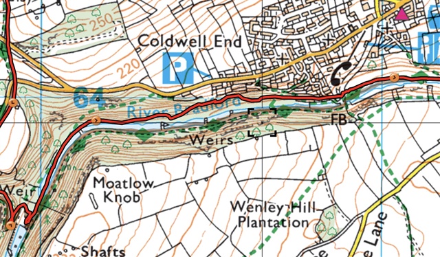
    The red line is the 67i recorded track. The iPhone track is the grey one a little to the south, following the green diamonds.

    The iPhone is correct insofar far as I definitely followed the South side of the river. This happened twice on the same walk, both in wooded areas which may be relevant.

    There is about a 60m difference.

  • That's interesting, siabod.  I hope you'll get feedback from Garmin Support and share it here.  From your image it would be hard to dismiss the misplaced points as outliers or map dislocation.  The 67i points are consistently north of the iPhone points.  I assume the iPhone had cell service to refine its position.  Also, it's unlikely the 67i was correct and both the map and the iPhone were misaligned.  Since you had multi-band off, it's possible a key satellite was to the south.  If so, the south slope might have blocked a direct signal causing the receiver to use a reflected signal from the north bank.  That's especially likely at the river bend where there is a more parabolic reflecting surface to the north.  That would have moved the 67i's calculated position northward. I don't know enough about the geometry to know if that could account for an error with a magnitude of 60m. The location appears to be about 53.171250294207525, -1.6969024627201863.  If so, it would be interesting to see what happened to that track to the east of the posted image where the southern slope becomes lower or to the west where you were at a higher elevation.  By the way, I'm using firmware 8.90.  The firmware version difference wouldn't explain the error though.

  • Thanks for your detailed reply, jlg2.

    This is the other anomaly from the same walk, again a steep sided wooded valley. This time the Garmin track is to the South of the iPhone one by approx 30 metres, the iPhone one still being the correct one. This is 1.64 miles North-West of the first anomaly.

    There is not much track to the east of the first anomaly, but enough the see the that the two tracks synchronise as the valley flattens.

    The original location was 53.172133, 53.172133, 167 metres elevation . This one is 53.188741, 53.188741, 190 metres elevation.

  • Ì report the same finding.

    Software: 8.90

    GPS software: 11.02

    Multi-GNSS & multiband enabled

    Actually it is quite repeatable. If I leave it horizontally on the kitchen table near the window, the coordinate wanders away.

    Off/On switching immediately solves the problem.

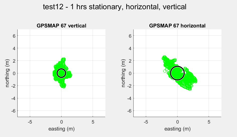
    In next picture the distance error is about 20m. I left the device stationary in the garden, clear sky view. First one hour vertical, then one hour horizontal. Startup error resolved in 5 minutes.

    I once recorded a 152 m error.

    I have the idea (though not hard confirmed) that it occurs or occurs more when the device is horizontal.


    It is not always: in next picture I left the device 12 hours unattended (1 measurement every second), but upright and plotted the distance with respect to the average reading.

    Average error 1.13 m

  • That's interesting.  You probably have already heard that the antenna is tuned to focus on a 2-pi-steradian hemisphere.  I wish I knew more about the geometry of location calculations.  If the device is horizontal it's only hearing satellites from 1 pi steradian of the sky, and what's probably more important is that the half it's hearing from is all in one direction.  I assume the closest satellites more directly above are less important for calculating direction.  I wish Garmin would tell us more about how the device calculates its position.  In particular, I'd like to know if each new track point is independent of preceding track points and independent of the accelerometer.  I'd also like to know what effect the accelerometer has on the recording frequency both in and out of expedition mode. If users knew more about that, a lot of these errors would be predictable if not easy to avoid.

  • Thanks for the response. The difference in precision between horizontal and vertical (measured without the error apparently):

    Average error vertical: 0.75 m, horizontal 1.25 m

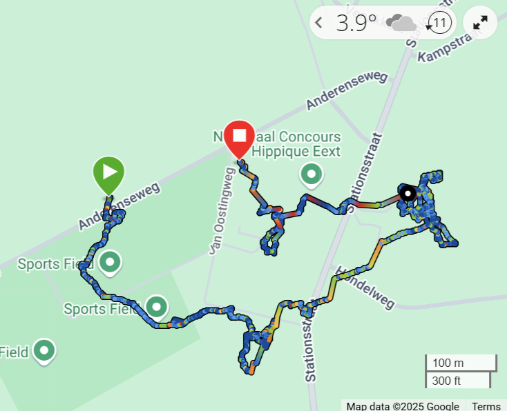
    Tonight I left my GPSMAP recording on the kitchen table near the window. Apparently it went out rampaging for 3.9 km ithrough our village. First horizontally, then vertically. It did not return.

    Indeed, it crossed my mind that it uses the accelerometers when reception is poor. But you should be able to switch off this feature...

    I hope they solve it soon, because this renders the device unusable

  • Baffling.  And others (also not in drone warfare zones) are reporting the same thing.  Reports that initializing the device by power-cycling corrects the error suggest a possibility of firmware failing to update some value used in location calculation.  And since the reports I've seen involve tests when the device was stationary, raises a possibility that movement may be needed to reinitialize the calculation.  Please post here any feedback you get from Garmin support.  

  • Movement required... crossed my mind. However this problem should not occur even without movement. And once introduced, it isn't solved by moving. The error persists. Only a power cycle seems to get it on its feet again.

    I also reported this to Garmin Support in the Netherlands and of course will let you know the result.