
Showcase and Forum for RouteIT Datafield
Feedback, Suggestions, Questions? Here's the place to let me know :-)

Description:
Trial version runs for 20 minutes before prompting payment. Restarting activity resets trial period.
RouteIT is a datafield for route navigation that also displays up to 8 configurable data fields and a HR zones graphic! Automatic zoom adjustment when you head off-course or start your activity far from the start of the route. Route navigation is provided using the dynamicWatch service (https://dynamic.watch/). It displays your downloaded dynamicWatch route as well as a breadcrumb trail when you are off-track.
By fitting all these features into a data field rather than an app, you're able to use this in the default garmin activities with all the built-in features such as workouts, alerts, livetrack while mixing it up with other data field pages as you like them.
- dynamicWatch route shown with a red line, route start and route end shown by green and blue squares respectively.
- Activity start location as a green circle
- A breadcrumb trail of your path since activity start when you are more than 100m off course.
- Your current position and bearing shown with a blue arrow
- Configurable size for map lines, position arrow, and markers
- The full-scale map is North-up orientated and will rescale to keep the entire activity in-screen at all times, this is shown every minute for 5s, or when you are more than 500m off-course.
- Current map scale in shown in km (This indicates the distance shown for the entire screen width)
- 3 zoom levels:
- Full-scale map - shows entire route, path / track travelled and current location
- 1.6km zoom - shows area around current location when you are between 100m and 500m off-track.
- zoomed in - zoom level chosen automatically by activity (300m for running/walking, 600m for cycling). This view is used for route navigation and is track-up orientated
- Manual zoom mode: Pressing the pause button twice within 5 seconds will lock the zoom on on whichever zoom is currently not selected. (If the track is zoomed in, pressing the pause button twice will lock the view on full-scale mode. If the map is on full-scale, manual zoom will lock the map on zoomed in setting. When manual mode is active, the map scale will be shown highlighted in yellow.) Pressing the pause button twice again will re-activate automatic zoom.
- Up to 8* configurable datafields
- Optional HR Zone graphic indicating current zone and heart rate position in zone
- Optional background colour for speed/pace datafields (red if under pace, green if on and blue if greater than 10s above pace)
- Datafields can be hidden in settings by setting to "None" to make the map full-screen
- Datafield only supports single field view
- Miles or km units set automatically in watch settings
*6 datafields on smaller devices such as Vivoactive 4s. Forerunner 735xt is limited to 5 due to screen shape and size
Configurable datafields include:
- None - This will remove this field entirely, enlarging the remaining fields and chart view
- Current Pace (in min/mile or min/km, selected automatically from watch settings)
- Average Pace
- Average Speed (in mile/hr or km/hr, selected automatically from watch settings)
- Current Speed
- Lap Pace
- Lap Speed
- Current Cadence
- Average Cadence
- Elapsed Time
- Lap Time
- Distance (in mile km, selected automatically from watch settings)
- Lap Distance
- Heart Rate
- Lap Count
- Altitude (in feet or meters, selected automatically from watch settings)
- Total Activity Ascent/Descent
- Distance to Start
- Clock (12/24 hr selected automatically from watch settings)
- Battery Percentage
Settings Instructions:
See: forums.garmin.com/.../changing-connect-iq-app-settings
There are many Youtube videos that will demonstrate how to change the settings for a ConnectIQ data field, and it is recommended to have a look at these if you are confused.
dynamicWatch Instructions:
A dynamicWatch account is required to create a route for this data field. This can be created here. Once you have an account, you need to find your Partner Access Code (PAC) to enable RouteIT to download the created routes. Your PAC can be found at https://dynamic.watch/link_codes/new. See screenshot below:
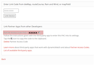
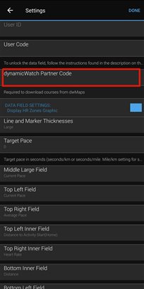
This PAC needs to be copied and placed into the settings for RouteIT via the Connect App on your phone or computer. See section above for instruction of where to find these settings. The screenshot below highlights where you need to place the PAC.
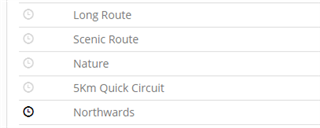
Once entered, the "dwMap Code REQ." message will disappear from the data field start page. On the dynamicWatch website you can then create a route that you would like to follow (https://dynamic.watch/plan). Once the route is created, make sure that the route is set as an active route by selecting the clock icon next to the route. When active, the clock icon next to the chosen route will be black, as shown by the example "Northwards" route below.
The route will now be loaded next time RouteIT connects to the internet. In order to connect, your watch needs to be connected to your mobile device with internet access. RouteIT needs to be set as an active data field in a Garmin activity such as run, bike or walk. Select the activity so that it shows the "Wait for GPS screen". Go to settings, select "data screens", select the screen where RouteIT is the active data field, and select Layout or "Edit data fields" so RouteIT is displayed. Start Garmin Connect Mobile and synchronize your device to ensure the bluetooth connection is active. A data field can only connect to the internet every five minutes, so patience is required. The new route will appear when download is complete.
If an incorrect PAC code has been entered, it will be discarded after an unsuccesful connection attempt. Therefore, if no route appears and the PAC code has disappeared from the settings file, make sure that you have copied the correct code from dynamicWatch.
Privacy Policy and Disclaimers:
This app does not store or collect user data, however, the connected service provided by dynamic.watch does require some personal info to be stored, the detailed privacy policy can be found at: dynamic.watch/.../privacy.
This app is intended to display track and map data for your interest only. Using the app as the sole navigational tool is not recommended. It can contain errors or provide inaccurate directions. It is the user responsibility to use this app prudently. Any use of RouteIT is at your own discretion and risk. The user is solely responsible for any damage or injury that results while using RouteIT.

