This discussion has been locked.
You can no longer post new replies to this discussion. If you have a question you can start a new discussion

GPS accuracy

Hey!

Im not impressed at all with gps ( all band bla bla) .

check those 2. my old 935 and 955S

connect.garmin.com/.../9066698646

https://connect.garmin.com/modern/activity/9052507601

one with 955s only

https://connect.garmin.com/modern/activity/9071886681

  • any chance to try to map it out using Google maps or some other mapping tool to see what is more reasonable?

    for total distance, on some known hikes and runs, i have found my 935 and 945lte, and now 955 all to be pretty consistent with one another.

  • I just can't say this is a better gps chip. Definitely not an upgrade at this level. 

  • I mean, there's a difference between a plot and the gps itself...

    At most the recordings are every second and who knows, maybe plotting is processed some other way. It's mountainbiking and speed is high in those screens. What would high speed be, 30k/h? That's 8.5m/s so at most it can record point at 8-9m distance from each other...

    The actual recorded points (the points between the straight lines) seem spot on the path so yeah, gps is perfect. It just can't record enough points to make a smooth path in between and/or the actual itself also adds some 'optimization'.

    My runs in all-mode have been spot on, with smart recording even, but there are simply technical limitations to gps and at higher speeds there's just so much precision you can get.

  • Thanks for the info. Guess that's the gps holly limit.

    On the positive side, I got a storm alert yesterday while recording mtb. Never had one in 3 years with 935. I'm guessing it's a new feature added

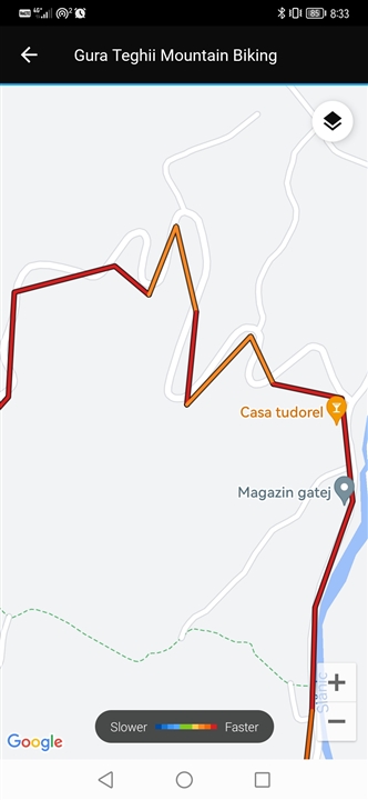
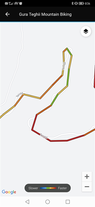
  • There's something fishy with the way Connect displays activities. Almost like it's undersampling the points just to display faster. I did a run and that track is extremely detailed in Connect in the overview but jagged when clicking on the map to make it fullscreen. Here's a small loop I did crossing a path specifically to see if the multi-band would capture it, and it did nicely:

    The fullscreen render is just plain horrible:

  • as i wrote before, the Garmin Connect layout has low resolution (using a "compression") for the track and it is the reason why your track is so jaggy , especially in the turns. (too less gps datapoints are DISPLAYED here due to server speed reason i think ) 

    You must upload your FIT files to Strava or QuantifiedSelf.io site (these sites are showing the gps track without any "compression") and comparing the quality of the tracks there. and one more thing, the map view is sometimes inaccurate (the streets /roads are not in the real position), You must switch to satellite view , that is much more accurate (especially the quantifiedself has accurate google map satellite views, the Strava has mapbox, which is not so accurate )

    if You can share the original FIT files (in ZIP format here) i can do a quick comparisons for You (if you are not on Strava or cant do comparison on the quantifiedself.io site)

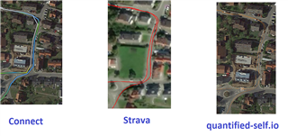
  • here is my last ride in Garmin Connect and on Strava (from same FIT file), as You see , the Connect track is awful jaggy due to displaying limitation, the Strava ones is perfect, as the 3rd one too. 

  • Be aware that the garmin map isnt that precise as - for example strava. That can also make a diffrence. 

  • My route of cadair today was same up but GPS was showing a good 30m off course on way back down. Everything else seems spot on apart from this one.