
Has anyone else noticed relatively recent grossly inflated elevation gains on activities following an update, possibly some time this year? I now see this all the time.
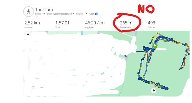
Examples:- 2 hours walking around a completely flat running track and rugby field on a stable pressure sunny day. Elevation gain 265m
2) 400m sprint intervals on a completely flat surface for 40 minutes total time. Gain 50m
3) Different rugby field for 2 hours, 65m gain.
All runs now seem to finish 30-40m different elevation to where they started at the same spot.
Even turning the altimeter to manual correctly setting the pressure from a calibrated weather station and elevation from a proper topo map immediately before starting an activity it fails to be accurate.
The sensor itself is clean and works normally outside activities other than drifting due to pressure changes (dumb algorithm).
This is clearly barometric sensor related as if i go onto Garmin connect and change the elevation source to DEM then the 265m magically becomes a more plausible 6m, the 50m becomes 9m and 65 becomes 12.
The problem this causes is it thinks even flat activities are on a large gradient so affects pace, effort level, vo2max and so on, artificially inflating them.
Last year and earlier although there were as expected SOME inaccuracies, they were fine and well within limits. But a 200m elevation difference on a flat surface etc are so far out of range they're a problem.
I assume theres no way to switch OFF the barometer in activities and rely on the theoretically much less accurate GPS and DEM?
