This discussion has been locked.
You can no longer post new replies to this discussion. If you have a question you can start a new discussion

HOW TO: Make course line easier to see

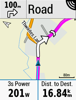
For some reason Garmin use a thin dark purple line for guidance if you're following a course. This annoys me (not least because if you navigate to a waypoint you get a nice chunky magenta line), so I've tweaked the map theme file to fix it. This is how it looks on my Edge 530 when navigating a route:

If I get around to it I'll make a tool that lets you pick your own colours and generates a theme file for you.

You need to edit one of the MapTheme files (/Garmin/MapThemes/Classic.kmtf) and add the following lines to the <stylelist> XML category:

<style field="MPM_ACTV_CRS_CLR">
			<color>
				<primary day="#ffff00ff" night="#ffff00ff"/>
				<secondary day="#ffff00ff" night="#ffff00ff"/>
			</color>
		</style>
 

  • How many people complain about it?

    There will always be people that don't like how something works.

    Having things work the same way (consistently) or simply is also a "good feature".

    Compromises have to be made.

    Garmin could have easily prevented the file from being "hackable".

    (Anyway, I'm not sure if editing a text/xml file is really "hacking".)

  • I, for one, am complaining about it for at least four reasons:

    1. The existing course line is virtually indecipherable from streets.  the only thing I can discern is the chevron.  I can't believe that I am the one who finds this unacceptable.

    2. Our late Oregon 600 had bright magenta course markings. Ive spent an inordinate amount of time trying to figure out how to get the same course markings after transitioning to the 840.  which leads me to point 3,

    3. IMHO Garmin's user interface design is ... awful.  I went through the same painful learning curve with the Oregon 600 8 or so years ago, and I'm (dis)pleased to say it's gotten worse.  The layout and categorization of settings doesn't seem at all intuitive or natural.  Which brings me to point 4, which is;

    4. Terrible documentation, which is poorly written, incomplete, and very badly organized, almost like a collection of random how tos.   for example, this morning I was attempting to learn how to upload courses from a tablet filesystem and then to upload those same courses to Garmin Connect.  I succeeded finally, but not without the help of others and Google.

    Another example - following a course yesterday it decided to stop navigating and instead simply said "follow the road" (or something like that).  I could find no way to get it to resume the course we were on (we were, in fact still on the course) without going back to the Navigation glance and reloading the course.

    Truth in advertising - I am new to the 840 (but as noted not new to GPS navigation or Garmin), but it should not be this challenging, nor should it depend on knowing Garmin's quirky way of doing things.  Some of what we're experiencing may be learning curve, but again, if so, the learning curve is either too step or badly documented.

  • I also do not like the way the map. I would like to make both the triangle and the track line a little bigger, but garmin does not listen to people complaining about it.

  • I have recently used a custom MapTheme which has most of the additional ground cover items like woods, forests etc being the same color as the general background and this gives a nice uncluttered map, a bit like the high contrast theme but with classic road colors, I will post some screenshots shortly

  • Hello L.Rouge.  Do you have a .kmtf file from the above theme that I could upload to my edge 1040 please ?

    Thank you !

  • And a further request for @L.Rouge please: could you also provide pointers as to how/where to update the .kmtf file?  I’m a hardware guy, so manipulating s/w constructs has never been my strong suit.