This discussion has been locked.
You can no longer post new replies to this discussion. If you have a question you can start a new discussion

Not following route - why?

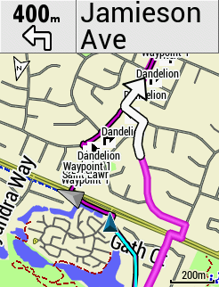
Why is the 530 not faithfully following the route - it seems to recalculate it's own path and avoid this section of my planned route.

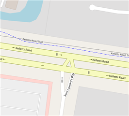
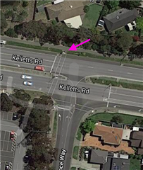
First time it happened it confused me so much i nearly knocked into another cyclist - i've now gone back to the same spot 3 x and it consistently always not doesn't follow my route (photoshopped green arrow showing my route (magenta color)). Instead it reroutes to the main road......I have disabled recalculation - so it shouldn't recalculate and should just blindly follow my route ????

  • On the same ride - different spot - here again it ignored my route (dull magenta) and suggested it's own route (bright pink).

    Again - i can confirm that I've disbaled Recalculation. 

  • Just noticed i've got Popularity Routing 'On' - but that shouldn't affect my routing - yeah? THat should only kick in at recalculation?


  • What maps are you using?  Those aren't the Garmin ones.  Where is that place that you have the issue?  Have you checked out the underlying map data?

    Maybe there is something in the map that prevents the unit following your planned route at that point.  I have had my Garmins deviate from planned routes a little at time for some reason.

  • What makes u say they are not Garmin original maps?

    Those are Garmin Cycle Maps for Australia. It's Melbourne (best city in the world). I have disabled the OSM maps.

    Map settings:

    Worldwide DEM basemap NR - Enabled

    Garmin Cycle Map AUS/NZ 2020.10 - Enabled

    Garmin DEM Map AUS/NZ 2017.20

    ALL OSM MAPS ARE DISABLED.

    What makes u say they are not Garmin original maps?

    At least it's consistent - the result is the same everytime i approach this route - for some reason it doesn't like that dotted line path - IRL the dotted line is a bicycle / walking path.

    My avoidance settings:

    Select Items to avoid:

    Major Highway - Disabled

    Toll Roads - Enabled

    Unpaved ROads - Disabled

    Ferries - Enabled

    Narrow Trails - Disabled

  • It's what I call the "short cut" problem. It's been a problem with units at least as far back as the 800.

    The way the units create "turn guidance" is to walk the track and selecting roads/paths the track appears to follow.

    The result of this is a second route/track (the light magenta line).

    The original (loaded) track is the magenta line with black borders.

    Usually, the second track follows the first fairly closely but, once in awhile, you get the short cuts in the second track.

    Unfortunately, it appears  there's nothing that one can do anything about it.

    It has nothing to do with avoidance settings.

    =======================

    The avoidance settings aren't used when using a course anyway.

    Since the whole point of using a course is to pick the roads you want to use, you don't want the avoidance settings to do anything.

    If the avoidance settings did anything with courses, it would often force the use of roads you didn't choose (defeating the point of creating the course).

    ========================

    Note that the default Garmin maps are using Openstreetmap data.

    You can get odd issues like this if you use a map that is based on other data (or with newer or older data).

    But that is what appears to be going here.

  • What makes u say they are not Garmin original maps?

    The colour scheme is different to the Europe Gamin maps so I thought they weren't Garmin maps.  I was wrong.

  • Most of the maps used on the Garmins (now) are OSM based. If it's an OSM map, it doesn't matter if it's not the Garmin map (generally).

    It's more likely that people use a non-OSM map to plan the route. That isn't ideal but it generally works OK.

  • Were you on Saint Lawrence Way attempting to head onto the bike path on the other side of the dual carriageway?

    If so, then there doesn't apear to be any link road that would allow the edge to do that.

    It may the case that you know that there is a shortcut, but the Edge doesn't as there isn't anything in the map to say otherwise.

    How did you create the route that allowed for this shortcut?  Was it a route from a previous activity by any chance?

    Regards, Dave

  • So, it's a map issue (not what I suggested it might be).

    The Edges won't make jumps between roads. The routing only follows roads/paths.

    Was it a route from a previous activity by any chance?

    Probably not. The ramp from the street is to the west of where the track goes from the road to the sidepath.

    I updated OSM to add the access there. So, someday, the routing should work.

  • Ah - yes - you guys are correct - on the map there's no link from the road to the path at the junction. IRL there is the pedestrian ramp connection but that's not showing on the map.

    I played with RidewithGps again and can confirm i think i must have manually drawn a direct route to the path. Because RidewithGps would not route straight to the path also. 

    So i learnt something today - the Edge does not blindly follow the route - it will over-ride the incorrect section of the route and re-route if it cannot correctly go along the planned route.This is different from recalculation - it's just re-routing a small section of the route, and coming back to the original route as early as possible.

    Just as  said - the Garmin Edges travels along roads/paths etc....it's not travelling along the magenta route.  


    Nice findings. 

    Thanks guys.