This discussion has been locked.
You can no longer post new replies to this discussion. If you have a question you can start a new discussion

Not following route - why?

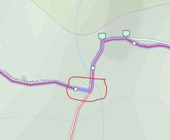
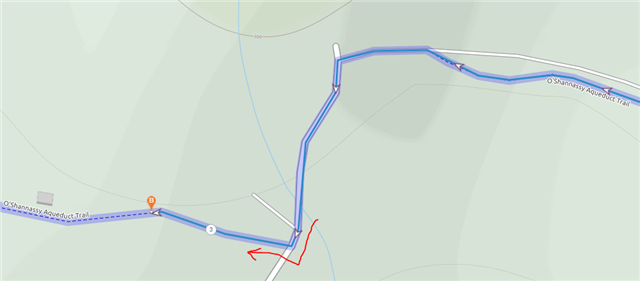
Why is the 530 not faithfully following the route - it seems to recalculate it's own path and avoid this section of my planned route.

First time it happened it confused me so much i nearly knocked into another cyclist - i've now gone back to the same spot 3 x and it consistently always not doesn't follow my route (photoshopped green arrow showing my route (magenta color)). Instead it reroutes to the main road......I have disabled recalculation - so it shouldn't recalculate and should just blindly follow my route ????

  • So the 530 will abide with RidewithGPS' autorouting algorithm.


    RidewithGPS wasn't able auto route from main road to this trail (O'Shannassy Aqueduct Trail) - the spot where i want to get off the road to join the Oshanny trail. 

    So even if i can force (manually) RidewithPGS to plot the road to connect to the OShanny trail the edge will ignore my route and go along with RidewithGPS's auto routing - that means i will miss the turnoff for the OShanny trail - yeah? 

    What's the workaround for this - break the route up into sections?  End the current route at the road / start of the Oshanny Trail. And start a new route at the OShanny trail?


  • Edge units do not use the routing algorithms of route planners such as RwGPS.  They follow the route in the file and calculate their own directions based on what map features the route takes them over.  If the paths in question are connected in the Garmin map then it will likely route you just fine there.  If they aren't then the Garmin will detour around the gap.

    In the screenshot it looks like there is a gap between the paths which is throwing RwGPS off.  If they do connect then the map needs to be fixed in OSM and at some point RwGPS's routing engine will update itself to route properly in that location.  Gaps in the maps would throw any device using the maps off as you can't route across a gap.

    The easiest work around is to just ignore the directions to route around the glitch and just carry on as you would to the road.  The Garmin will carry on giving directions as normal if you skip bits of the route.

  • So even if i can force (manually) RidewithPGS to plot the road to connect to the OShanny trail the edge will ignore my route and go along with RidewithGPS's auto routing - that means i will miss the turnoff for the OShanny trail - yeah? 

    There is "no going along".

    The file you copy to the Garmin (from whatever source) is a track and nothing but a track.**

    Route planners, like RWGPS, use routing algorithms to produce the track. But the Garmin had no idea how the track was created.

    The Garmin creates a route using its internal algorithm and internal maps by moving along the track and picking roads/paths the track appears to be following. This process works even if the track doesn't follow roads/paths exactly but there needs to be usable roads/paths.

    --------------------------------------------------------------

    ** The can also, optionally, contain "course points". If it's enabled on the device, the device will display them as a pop-up when you reach them. These are the way units that don't have maps provided turn instructions. These are separate from the "turn guidance" routing (the big white arrows).

    Having the course point before the turn makes them more reliable (they are very sensitive to location). With their default locations (at the turns), they often announce after I make the turn.

  • So even if i can force (manually) RidewithPGS to plot the road to connect to the OShanny trail the edge will ignore my route and go along with RidewithGPS's auto routing - that means i will miss the turnoff for the OShanny trail - yeah? 

    Long term, the map should be corrected.

    Short term, you should connect it manually and you will get an off course warning if you don't make the turn. You can also add a course point before the turn and enable "course pints" on the device. And, you should keep an eye on the map (it's easy enough to miss turn announcements and, sometimes, the units won't create turns where you might expect them).

  • road to connect to the OShanny trail

    There is a "kissing gate" that was blocking routing. On Google Streetview (from 2008), it shows a bollard there (not a kissing gate). I changed it to be a bollard. That might (possibly!) allow the routing through that point.

  • So when autorouting doesn't automatically route properly (when laying the route in RidewithGPS) it's a red flag that something is amiss or dodgy to the map information at that spot. In previous times I would simply switch to manual modes in RidewithGPS and manually 'force' the course/route to the shape i needed it to be...thinking that the 530 would faithfully follow the route i had created. I learned now that the 530 will PRIORITIZE the map's directions over my route (course) when there is an anomaly. The anomaly will be obvious when RidewithGPS fails to join the dots over the anomaly spot and instead plots a go-around.

    For now might be best for me to end the route where the anomaly is and start another new route at the beginning of the anomaly for the next section of the trip - this would avoid the potential of missing the turn-off.

    Hmm...i also see the merits of enabling the Off Course warning now. 

    Oh - wait - i tried plotaroute.com and it auto plotted with no problem at the same spot...but of course i don't know how the 530 will perform until i am actually riding the route.

  • So when autorouting doesn't automatically route properly (when laying the route in RidewithGPS) it's a red flag that something is amiss or dodgy to the map information at that spot.

    Yes, that's information that there might be a map problem.

    I learned now that the 530 will PRIORITIZE the map's directions over my route (course) when there is an anomaly. The anomaly will be obvious when RidewithGPS fails to join the dots over the anomaly spot and instead plots a go-around.

    What you are providing the 530 is a track (a list of points that traces the curves and turns of the path you want to follow).

    There are no turn instructions in the file (it's just track data).

    The turn instructions (what Garmin calls "turn guidance") is generated by the device.

    Oh - wait - i tried plotaroute.com and it auto plotted with no problem at the same spot...but of course i don't know how the 530 will perform until i am actually riding the route.

    So, plotaroute's routing ignores "kissing gates".

    The thing you are sending to the device regardless of the planner you use is a track. That is, the file produced by RWGPS or plotaroute has the same data (the track points might be a bit different).

    The turn instructions are generated by the Garmin using the maps installed on the device.

    • The tracks from RWGPS and plotaroute are (essentially) the same.
    • The map used to generate the turn instructions is the same.
    • The 530 will do the same thing.
  • For now might be best for me to end the route where the anomaly is and start another new route at the beginning of the anomaly for the next section of the trip - this would avoid the potential of missing the turn-off.

    It's really a "discontinuity" (rather than an "anomaly", which is a more general term).

    If you find a discontinuity, ending the track there and creating a new track starting there is reasonable to do.

  • Thinking out loud -so the 530 will follow my planned route as long as my route is obeying the rules of the land. Otherwise it will abandon my route and do a go around based on the rules of the land. What i mean by that is that the 530 shouldn't be able to take the cyclist against traffic - or going opposite into a 1 way street.  

  • the 530 shouldn't be able to take the cyclist against traffic - or going opposite into a 1 way street.

    As long as the map data is correct yes.