This discussion has been locked.
You can no longer post new replies to this discussion. If you have a question you can start a new discussion

Strava (not Garmin after all) broke climbpro

I've seen a few posts on this and made some myself, but I now have conclusive evidence that Garmin have broken climbpro in the transfer of routes from Strava (and maybe other platforms) to Garmin Connect.

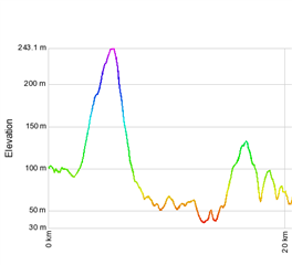
The problem is that Garmin recalculates the elevation data, but makes a mess of it. The image below is the elevation of the same route (via GPSVisualizer), one trace is  from Strava, and one is from Garmin Connect after transferring it through the API (favourite the route in Strava and it comes through automatically).

Heres the Garmin vs Strava elevation at the start of the route
and here it is at the end
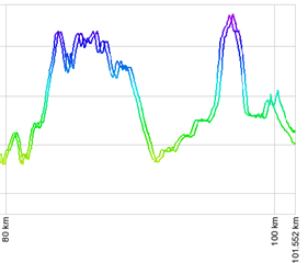
Heres the full trace, at the start of the elevation profile its fine, at the end its way out.

  • Hi, there was always an offset during climbs, what happened was that the current position was showing me on a climb while I wasn't yet on it

  • So this problem still exists. It happened on our club run this morning, and its mildly annoying me that Strava aren't taking it seriously.

    I tried to work out a way of proving it once and for all and came up with the idea of a route that just loops the same course over and over again. I created one of 15 laps of Richmond Park and dug into the data.

    I isolated a single fixed point on each lap, the highest point, which only appeared once per lap in each gpx file. Here's the route if anyone wants to try it, to reproduce, transfer it to Garmin via the API (if you've linked accounts you just need to favourite it), download gpx files for both routes and look for the data points with 56.42m elevation. The coordinates are identical in the original but drift on every lap in the copied file.

    Highest Point GPX Coordinates for 15 laps of Richmond Park
    Lap Elevation Latitude from Strava GPX Longitude from Strava GPX Latitude from Garmin GPX Longitude from Garmin GPX Transferred Course  Latitude Change from Original Transferred  Course Longitude Change from Original
    1 56.42 51.44506 -0.29385 51.44516 -0.29390 0.00019% 0.01714%
    2 56.42 51.44506 -0.29385 51.44518 -0.29391 0.00023% 0.02031%
    3 56.42 51.44506 -0.29385 51.44519 -0.29392 0.00026% 0.02345%
    4 56.42 51.44506 -0.29385 51.44521 -0.29393 0.00030% 0.02661%
    5 56.42 51.44506 -0.29385 51.44523 -0.29394 0.00033% 0.02975%
    6 56.42 51.44506 -0.29385 51.44525 -0.29395 0.00037% 0.03289%
    7 56.42 51.44506 -0.29385 51.44527 -0.29396 0.00040% 0.03605%
    8 56.42 51.44506 -0.29385 51.44529 -0.29397 0.00044% 0.03919%
    9 56.42 51.44506 -0.29385 51.44530 -0.29397 0.00047% 0.04236%
    10 56.42 51.44506 -0.29385 51.44532 -0.29398 0.00051% 0.04549%
    11 56.42 51.44506 -0.29385 51.44534 -0.29399 0.00054% 0.04863%
    12 56.42 51.44506 -0.29385 51.44536 -0.29400 0.00058% 0.05180%
    13 56.42 51.44506 -0.29385 51.44538 -0.29401 0.00061% 0.05494%
    14 56.42 51.44506 -0.29385 51.44539 -0.29402 0.00065% 0.05810%
    15 56.42 51.44506 -0.29385 51.44541 -0.29403 0.00068% 0.06124%
  • Can you share how the data was created?

  • Sure

    Favourite the route so it gets transferred to Garmin

    Download the gpx files from Connect and from Strava

    Load the files into Excel as XML, it should create a row per record (it'll grumble a bit but the data will be there)

    Filter by the elevation column value = 56.42 should show 15 rows in both

    Check out the data

  • So, you've created a route in Strava and sent it to Garmin. The rout is fine in Strava, but the version in Garmin Connect is clearly wrong since it places the same elevation point in different places in the map.

  • Yes. It moves the elevation point roughly 2 metres on every lap. This is done by strava creating a new set of route data adding additional data points on top of the strava route (4x as many data points roughly). 

    I don’t really know why Strava does this vs just transferring the basic route. Garmin does like a lot of data points but the current method makes things worse not better. 

  • What makes you convinced the issue is caused by strava?

  • Because both Strava themselves and Garmin have confirmed that it’s an issue caused by Strava. Strava even made an update that improved things, but didn’t fix it. 

  • I'm still not convinced it's a strava problem. I have the same issues with routes created with Garmin connect or with automatic climbs from ClimbPro

  • Yes I’ve seen other issues with elevation elsewhere too. It’s a big mess. This particular issue is from Strava but agree there are plenty of other issues. I believe these have always existed but climbpro has made them much more visible.