This discussion has been locked.
You can no longer post new replies to this discussion. If you have a question you can start a new discussion

Strava (not Garmin after all) broke climbpro

I've seen a few posts on this and made some myself, but I now have conclusive evidence that Garmin have broken climbpro in the transfer of routes from Strava (and maybe other platforms) to Garmin Connect.

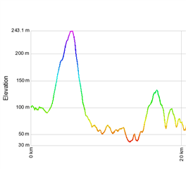
The problem is that Garmin recalculates the elevation data, but makes a mess of it. The image below is the elevation of the same route (via GPSVisualizer), one trace is  from Strava, and one is from Garmin Connect after transferring it through the API (favourite the route in Strava and it comes through automatically).

Heres the Garmin vs Strava elevation at the start of the route
and here it is at the end
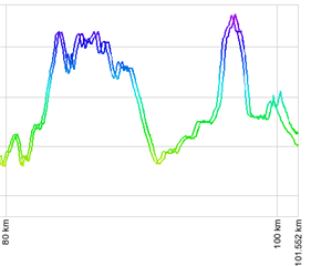
Heres the full trace, at the start of the elevation profile its fine, at the end its way out.

  • A couple of things here. This appears to be a course related issue, so nothing to actually do with ClimbPro. ClimbPro just uses the course data.

    Gamin Connect in theory does not make any changes to elevation data coming in via the third party ingeneration's. It just loads up what it is provided with. If it were replacing the elevation data then I would expect to see difference along the whole course and not just at the end.

    What format are you using to export from Strava?

  • While its technically correct that its a course issue, the impact is seen most clearly in climbpro when you're using it to pace up a hill. The trace above is from the Hell of the Ashdown sportive last weekend, and when I'd reached the top of Brasted Hill, Climbpro showed me as still below the really horrible 25% bit. I heard the same from others in our club and anecdotally elsewhere (e.g. gplama has confirmed he's seen it on twitter), others have stopped using climbpro because of it

    I don't know why garmin replace the elevation data, but as the data has changed I don't see another explanation. I think they do, as there was a bug (pre climbpro) when they first created the courses transfer API, that the whole elevation data was garbage after transferring a course from Strava using the API. I might be able to find a post on it but it could be before the forums were migrated.

    Unless Garmin have already fixed this, you can reproduce fairly easily as follows:

    Create a route on Strava, or favourite one.

    If you have Strava linked to Garmin it will be automatically transferred and a matching course created in Garmin connect

    Export the gpx from Strava and from Garmin Connect

    Fire up https://www.gpsvisualizer.com/profile_input

    Choose the two files in the "Upload your GPS files" section on the top right

    Change track/line options cumulative distance to "No"

  • It’s not the elevation data that is out it’s the distance.  You can see it’s an ever increasing drift.  The actual heights remain the same but shifted over. 

    if you created the same course directly in Garmin and used it would it then match?  I suspect it would. So it’s a course conversion error in distance. 

  • Yup, pretty much. I haven't tried creating a course directly in Garmin, but suspect you're correct.

    Interestingly though, there's no distance specified in the GPX, just GPS coords.

  • What Strava sends across is FIT not GPX. FIT has both cords and distance. That was why I was asking what format you were exporting from Strava with to do the comparison.

    The comparison tool if you are using GPX as one of the inputs and FIT as the other could be taking the distance from the FIT and computing distance from the coords from GPX.

  • Interesting. I used both GPX files to compare on the visualiser. Had no visibility of what file was sent as the transfer is behind the scenes. I'm pretty sure though this is a fairly recent issue. I have hundreds of strava routes and only really noticed it recently (like the last few months)

  • Let me create a new course and take a look

  • I could image that the GPX exports are dropping a point at different distances. Do you know how many data points are in both files? 

  • The garmin gpx has 33548 lines with 4 per trackpoint so about 8300 data points, strava has 5500 with 3 lines per trackpoint so about 1830 data points. It looks like Garmin are remapping the whole course.

  • Just tried a route I transferred via the API in september 2022 and thats fine, so something went wrong after that. 

    Edit: I think it might have happened in a 2 week window between the 29th of December and the 14th of Jan, but can't be 100% sure