This discussion has been locked.
You can no longer post new replies to this discussion. If you have a question you can start a new discussion

Strava (not Garmin after all) broke climbpro

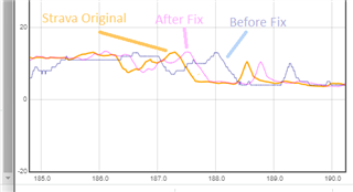
I've seen a few posts on this and made some myself, but I now have conclusive evidence that Garmin have broken climbpro in the transfer of routes from Strava (and maybe other platforms) to Garmin Connect.

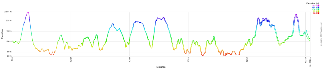
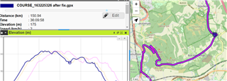
The problem is that Garmin recalculates the elevation data, but makes a mess of it. The image below is the elevation of the same route (via GPSVisualizer), one trace is  from Strava, and one is from Garmin Connect after transferring it through the API (favourite the route in Strava and it comes through automatically).

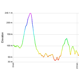
Heres the Garmin vs Strava elevation at the start of the route

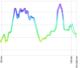
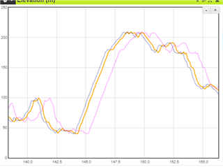
and here it is at the end

Heres the full trace, at the start of the elevation profile its fine, at the end its way out.

  • Here is a fun one.

    Route with about 6500' of climbing. Created on RWGPS. 

    - Sync from RWPGS to GC, it shows up as 6330'

    - Download as GPX and upload to Strava, sync from Strava to GC, it shows up as 6423'

    So far so good.

    On the 840, ClimbPro estimates climbing at:

    - 8110' with the RWGPS

    - 6532' with the Strava route

    Again its a route with 6500' actual climbing.

    Clearly something went wrong when ClimbPro used RWGPS route info.

  • Thanks for the update . Keep us posted. As soon as there's a fix/solution I'll retest (as an excuse to go for another ride Wink

  • I'm not sure if Strava will post or say anything, but they have posted a fix for this issue.

    The issue was limited to courses created from an activity. 

    If you see issues with courses that are just built using the course builder and not from an activity then that is something different that would need to be investigated.

    Update:

    Strava says that unstarring and restarring should be enough to fix the problem in the newly synced course.

  • Excellent news, I've just tried with a course that previously displayed the offset and looks much better. There does seem to be a bit of an offset still, but much smaller. Until I actually ride a route I won't know if that has any impact.

    Orange is original, blue is newly transferred by the API, pink is the previous API transfer

    EDIT

    The new import is still off by approx 200m in my test route. Hard to see but this is the descent past box hill and the low point is right on the corner, but the transferred course has it ~200m early. Better but not 100% fixed.

     .

    Heres the original Strava route which is spot on. (kudos here to mygpsfiles.com, makes this analysis very easy)

  • Would you be willing to share the activity file that was used as the source for the course?

  • I did PM a copy of a route showing a continued but smaller error. Seems to have got lost in the forum maintenance along with some of the most recent posts here so not sure if you got it. I’ll give Strava a couple of days and test again, but let’s hope it’s resolved now. 

  • Just checked again and better but not fixed. Example route is for Ride London 100 (given that its tomorrow) plus riding to the start and back. I have the original route, the route on Garmin before the fix, and the refreshed route on Garmin after I deselected and reselected the favourite icon in Strava.

    Here's the difference, this is showing the finish of Ride London where it goes over Tower Bridge. Note that although this is RL100 we ride to the start so tower bridge appears later than 100 miles into the route

    And here's where the elevation peak that should be on the bridge actually appears in the route

    Strava original, peak is on tower bridge at 187.3km where it should be

    Before the fix, peak is out by 700m at 188km

    After the fix, peak is out by 200m at 187.53km

    This route was imported from the official route, and then I added extra on the start and finish.

    I checked some other routes I created manually in the Strava route creator by drawing them, and they seem fine, so doesn't seem to apply to drawn routes, but indeed only ones created from a GPX (or previous activity) as aweatherall previously mentioned.

  • And Shane, no probs for you to use those pics if you do make another video and they're helpful (and I can share the files with you), just remember its Jeff not John Wink

  •  Rofl Thanks James...er... Jeff. I'm hoping for a 100% fix before looping back on this one. I'm keeping a close eye on these posts though. 

  • Thanks everyone for the thought investigation. 

    So, to summarize, can you please confirm 

    - creating a route from scratch in GC gives best results and no offset

    - not sure about creating a route from an activity in GC

    - creating a route from scratch in Strava gives some 200 m offset after 180+ km, but you have to star, then sync, unstar and sync again?

    - creating a route from an activity in Strava is the worst option, but there the workaround is to export gpx and manually copy to the device? Then no offset?