This discussion has been locked.
You can no longer post new replies to this discussion. If you have a question you can start a new discussion

Strava (not Garmin after all) broke climbpro

I've seen a few posts on this and made some myself, but I now have conclusive evidence that Garmin have broken climbpro in the transfer of routes from Strava (and maybe other platforms) to Garmin Connect.

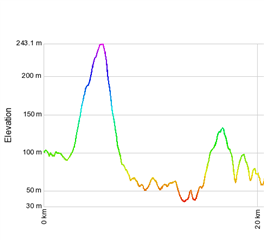
The problem is that Garmin recalculates the elevation data, but makes a mess of it. The image below is the elevation of the same route (via GPSVisualizer), one trace is  from Strava, and one is from Garmin Connect after transferring it through the API (favourite the route in Strava and it comes through automatically).

Heres the Garmin vs Strava elevation at the start of the route
and here it is at the end
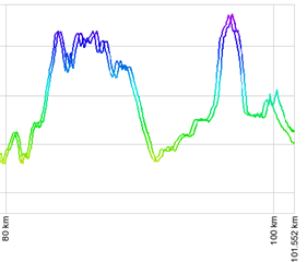
Heres the full trace, at the start of the elevation profile its fine, at the end its way out.

  • Thanks. I will try some routes in Europe.

    I have been creating routes in California and was not able to reproduce the problem. I'm wondering if it due to using different DEM maps that may have different resolution.

  • ClimbPro has generally worked well on my 530, except for 1 specific climb. Yesterday I provided details to Shane / GPLama, and repeating here:

    1. In Sept 2022, I looked at Strava for recent climbs on a local HC segment, found a ride with an appropriate starting point, and copied to my routes.

    2. Strava auto synced to my Edge 530 via Garmin Connect

    3. Did the route and experienced ClimbPro errors on the 4th and 5th climbs.

    4. Saw a GPLama post on another forum, and provide him with the Strava .gpx route. He loaded into GPS Visualizer against a Garmin Connect version of the same route. Here is a pic:

    (posted here: https://www.trainerroad.com/forum/t/climbpro-on-garmin/60480/76?u=windwarrior)

    4. Note the elevation error on the descent before the 4th climb. Verified this error was in the original Strava route, which was copied from another user's ride as mentioned above.

    5. Created the route from scratch in Strava, and no elevation error. 

    My conclusion is that the other user's original route had an elevation error before the 4th climb, which carried forward to the version in my Strava Routes. This was route was synced to my 530, and ClimbPro respected the elevation error, which introduced ClimbPro errors on the 4th and 5th climbs during the actual ride.

    Details of the ClimbPro errors on the 4th and 5th climbs can be found here:

    https://www.trainerroad.com/forum/t/garmin-edge-1040-released/73382/458?u=windwarrior

  • If you are willing to share the Strava course that you have noticed issue with I would like to take a look. Make the course public and then either send me the link via a private message or post it here.

    A general question on the courses that have these issues. Are they being created directly in the Strava course creator or are they being built from an activity or data imported from another source.

  • Hey, not sure if it helps but this is a course a guy in our club Dickie was using for Tour of Flanders at the weekend, which had the climbpro issue. What was interesting was the awful elevation quality in the Strava data, when imported to Garmin via the API it looked superficially smoother in the traces but still had the offset issue https://www.strava.com/routes/3075508387218625600 pretty sure the route was created on Strava using imported GPX data from the tour of flanders website, so maybe Strava isn't replacing all the elevation data, like 2infinite mentioned above

    Can't remember if I mentioned here but wondering if some of the offset is in the Haversine formula which uses (I think) the circumference of the earth, which has different values depending where you measure it.

  • I’ve deleted the route from Strava, but still have the .gpx from Strava. Send me a PM and I’ll email it. 

  • Thanks.

    I saved that course to my Strava account and exported it to GPX and then download the FIT from GC for the course and compared them and I see no difference in the visual comparison. 

    I do see differences in the data density and precision.

    The GPX file has 3,688 data points while the FIT file has 3X the number of data points at 11,787.

    Elevation in the FIT file uses integers and reports in meters. The GPX expresses elevation to 1 cm.

    Maybe I'm not using the compare tool correctly.

    TourOfFlanders_2023.gpxCOURSE_152668671.fit

  • Flanders Strava GPX vs Same route imported to Connect and exported as a GPX. Offset starts to appear ~60km. 

  • Not sure why its different for you,I don't seem to be able to attach files, or I'd send the ones I get when I export. Steps I followed are:

    1. Favourite original route in Strava so it gets transferred to Garmin Connect by the courses API (I didn't copy it)

    2. Export GPX from Strava route

    3. Export GPX from Garmin route that was created by the API

    4. View the GPX in https://www.mygpsfiles.com/app/ (bit easier than the original method I found that Shane is using)

    Edit, I tried copying as well and didn't make any difference, I could still see the offset. Also if you're using gpsvisualiser increase the profile width to 1200 or more to see the offset

  • Hey Shane did you import the GPX file manually or use the courses API to transfer? I get different results if I import the GPX (download from Strava, upload via the import button) when creating a new course. Edit, to be clear a manual import rewrites the elevation data but without the offset.

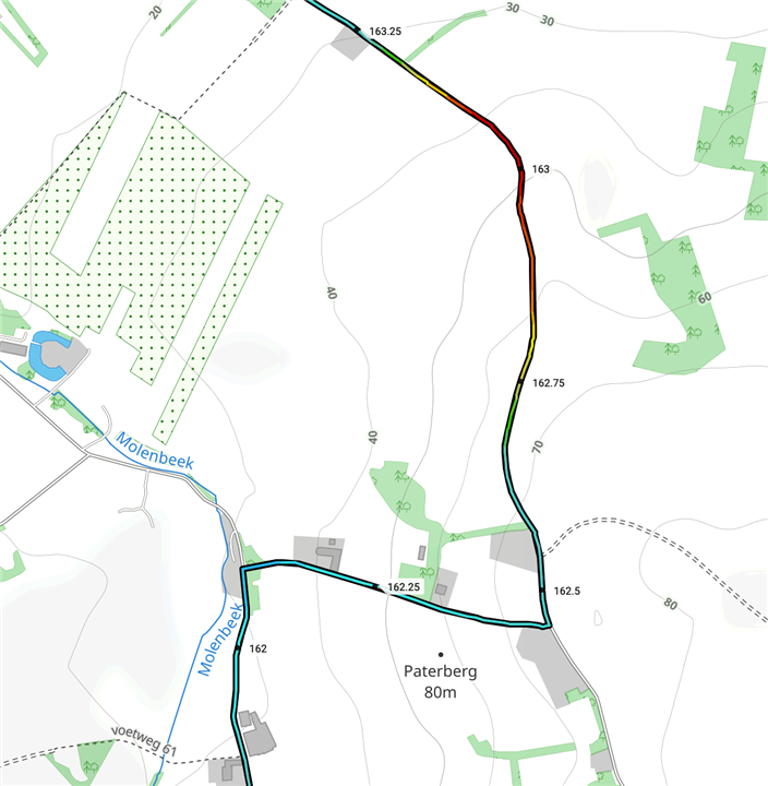
  • Courtesy of Ben at Veloviewer. If you use veloviewer you can upload a GPX file and see the gradient colour coded  here the ascent of the Paterberg (east/west section in the middle) from Tour of Flanders is offset to the downhill section