Improving course navigation visibility and responsiveness for trail running

Hi All,

I've been using my F7 for trail runs, and I find the whole experience to be somewhat frustrating thus far. With default settings, I find the map too difficult to read when bouncing down a trail in varying light conditions. It's way too busy with too much information on it. The map is very detailed and is not easy to read as you're trying to watch your footing and navigate at the same time.

I've done everything that I can think of to improve the visibility of the course, including the following:

1. Disabling the map entirely. Although, I still see very important features such as when I pass underneath a main road, so I suspect the map isn't layer is still being drawn.

2. Because I don't think there's a way to entirely disable the maps (see point #1), I set the map details setting to 'low'

3. I use the night map style.

4. Turn off auto-zoom - this feature can surely screw up your navigation in an area with many trails because the zoom level is always changing. And the font that's used to denote the zoom level is so tiny that you have to stop to see what it is... Not really a good implementation.

5. Set gps to 'all systems' - to address the lag and accuracy issues I'm seeing below. Note: I haven't tried 'auto select' yet - that's next. I am wondering though if the lag is due in part to the map being drawn in the background, even though it's disabled.

Doing the above, I mostly see a breadcrumb course trail, with little chevrons overlaid (and sometimes trail names). The chevrons help to effectively fatten the lines, making them easier to see. So mission accomplished on making the route a bit more visible. However, now I have the following issue: If I miss a turn, the route scrolls off screen rapidly, because the default position of the user is offset toward the bottom of the screen already. I also find the position to be quite laggy - this was clearly illustrated when I ran underneath the highway - the map showed me on the other side of the highway after I'd crossed underneath it. Where I run also has many twisting trails with heavy tree cover - so the lag, and the fact that the compass updates somewhat slowly, makes it difficult to tell which turns you're supposed to take. Maybe that would be helped by enabling the basemap, but then the screen is so busy as to be worthless.

I realize the highway underpass is a harder case, but the tree cover. - I'd hope the watch would be designed to have decent reception there.

IMO, course navigation seems to be optimized more for hiking than running, Is there something I'm missing with the above list that I should be doing to make the watch work better for navigating a course when trail running? While visibility is better - I'd hope to maybe be able to make the course line fatter, but there doesn't seem to be any way to do this.

  • Hello 7796725, I also use Locus Map to create routes and a Fenix 7 to navigate them. It is really annoying, they just don't work together. See my post: https://forums.garmin.com/outdoor-recreation/outdoor-recreation/f/fenix-7-series/332479/waypoint-alerts-shows-too-late

    Please, let us know how it works for you. I contacted both garmin support and locus Map support. Had no luck to fix that

  • I then transfer to the watch via USB or ftp (ConnectIQ app)

    Which one is this app? ftp? I cannot find the app. I was using the explore app to do this, but is not super easy way to transfer a gpx file with waypoints... maybe your option is better

  • Which one is this app? ftp? I cannot find the app. I was using the explore app to do this, but is not super easy way to transfer a gpx file with waypoints... maybe your option is better

    It's called gimporter.

  • I could no longer find gimporter but in the past it only worked with Android phones 

  • Hi Guys

    I did a trail testrun with my Fenix 7 Pro yesterday...horrible...partly.

    1. I used right away different maps with a better contrast. Also these maps are separated into smaller pieces (area Bavaria...) and are much faster in rendering than the original TOPO. So visibility is better, reaction time is better with moving map and GPS position display is nearly without any lag. So it is convenient to use this for navigation (details set to low, GPS Automatic, no Auto Zoom).

    2. I used my testtrack coming from Locus with TBT instructions as waypoint. Doesn't work at all on Fenix. No notification, no pop up. The Waypoints were just showed on the screen, not readable, because letters were too small.

    3. I used my testtrack coming from Garmin Connect with TBT instructions activated and transferred to Fenix. OMG, really? On every slight turn of the path you get a notification. Why? If the Fenix can route correctly with calculating a route, why doesn't it work by using a GPX file/route?

    Anyways, in addition we have this small black window at the button with the distance to the next TBT instruction. Approaching the next intersection, we get an additional black bigger windows with the arrow in it.......which covers up your current position including the map details of the intersection and so you cannot see, which path to take. Hey Garmin, are you trying out this *** yourself?

    Can we have the own position in the middle of the screen and not at the button third?

    Can we deactivate the popups and just use the smaller black windows at the button for the arrows? Maybe I didn't find the right configuration in the clear structured menu ;-).

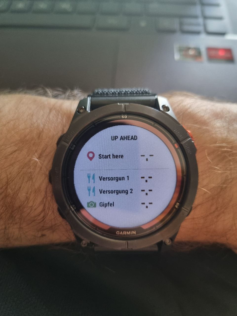
    4. The "Up Ahead" feature is working well, I think. I defined a aid station and a mountain top....and you get a good overview of them.

    Are these points also showed in the height profile? I can't remember.

    So my question to the community would be, how to get appropriate TBT instructions to the Fenix?

    - From Locus? No.

    - From Garmin Connect? No.

    Is plotaroute the solution? Do we know, how Garmin Connect integrates the TBT instructions into the .gpx .fit file?

    I would assume, that making a fitting format for the export to Garmin from Locus was your request to Garmin and Locus, right?

    I do not have any problems with Climb Pro yesterday (Newest Beta 14.x). Maybe you need to reset something.

    Thanks

    Some Additions:

    There is the opportunity to change settings in the activities setup with "Routing" from "Follow the Route (?)" (German "Strecke folgen") to "Use map(?)" (German "Karte benutzen").

    Follow the Route delivers the results at the top and discusses here. 

    "Use map" is theoretically doing exactly, what we want, meaning to recalculate the route/course (GPX file from somewhere without any TBT or waypoint) following the map information. Without trying this out, I would say, it generates TBT by map and should be better (solving switchback problem) than to use the ones "generated" from Garmin Connect and using setting "Follow the Route".

    I see three problems:

    - calculation time on the watch is long (7km course around 30sec on my Fenix 7 Pro)

    - I don't know, if you can combine this feature with the "Up Ahead" Waypoints

    - I don't know the behavior, if you leave the route. Does it try to recalculate right away? Wouldn't be good, if you need to wait 30sec again for recalculation, if you leave the route for 30m.

    Does anybody has experience with this setting?

    If this is only new to me, sorry. 

  • Hi 7796725, I asked to Garmin and locus to find the root of the issue and make the combo course creation by locus and navigation with Garmin work.

    Response of Garmin: Use our connect route planner (what a poor option, no thanks)

    Response of Locus: This is a Garmin's fault.

    In response to your second point about waypoints created in locus and then exported to connect and then exported to your watch:

    I have a lot of experience doing that, maybe I created more than 100 routes with the locus app, and then navigated with my Fenix 7.

    For me, locus is the easiest way to display waypoints into a route. So, firstable I tried same that you did. 1- create a route and waypoints with locus.2- exporting to connect. 3- exporting to the watch. In that case, the waypoints aren't showing in the up ahead page, also cannot receive alerts when approaching to them, but are displayed on the map on the correct spot.

    I tried several things, but the only one that kind of works for me is, between steps 2 and 3, add a step which consists in changing the icon of the waypoints with connect. With that simple step, you will receive alerts for every waypoint and the waypoints will be shown on the map and on the up ahead page.
    After a lot of testing, if you have a course with 8 waypoints for example, you change the icon of only 2 or 3 waypoints, you will receive alerts for all the waypoints. (This works almost always for me).

    And now is the big but...


    BUT, waypoint distance remaining on the up ahead is not correct and so, waypoint alerts are showing too late, from 10m to 300m late, even if the waypoints are properly displayed on the map. Usually, the incorrect distance becomes higher and higher in a course when the course has more and more kilometers. You can check photos and videos of that issue here: forums.garmin.com/.../waypoint-alerts-shows-too-late

  • Is plotaroute the solution? Do we know, how Garmin Connect integrates the TBT instructions into the .gpx .fit file?

    It is somewhat of a solution. The TBT works, but there is the occasional odd message about an upcoming turn in 200(0?)ft. I didn't troubleshoot to see what was causing it. But overall, I would try it - it's a better solution than garmin connect, and you can fine tune the directions.

    I don't know the behavior, if you leave the route. Does it try to recalculate right away? Wouldn't be good, if you need to wait 30sec again for recalculation, if you leave the route for 30m.

    I use course mode, so don't rely on the auto route generation in the watch. In course mode, it will not recalculate.

  • Hi Guys

    I invested some money to try Plotaroute. The feature "Snap Route to map", which includes the TBT instructions coming from the map data, is a Premium feature.

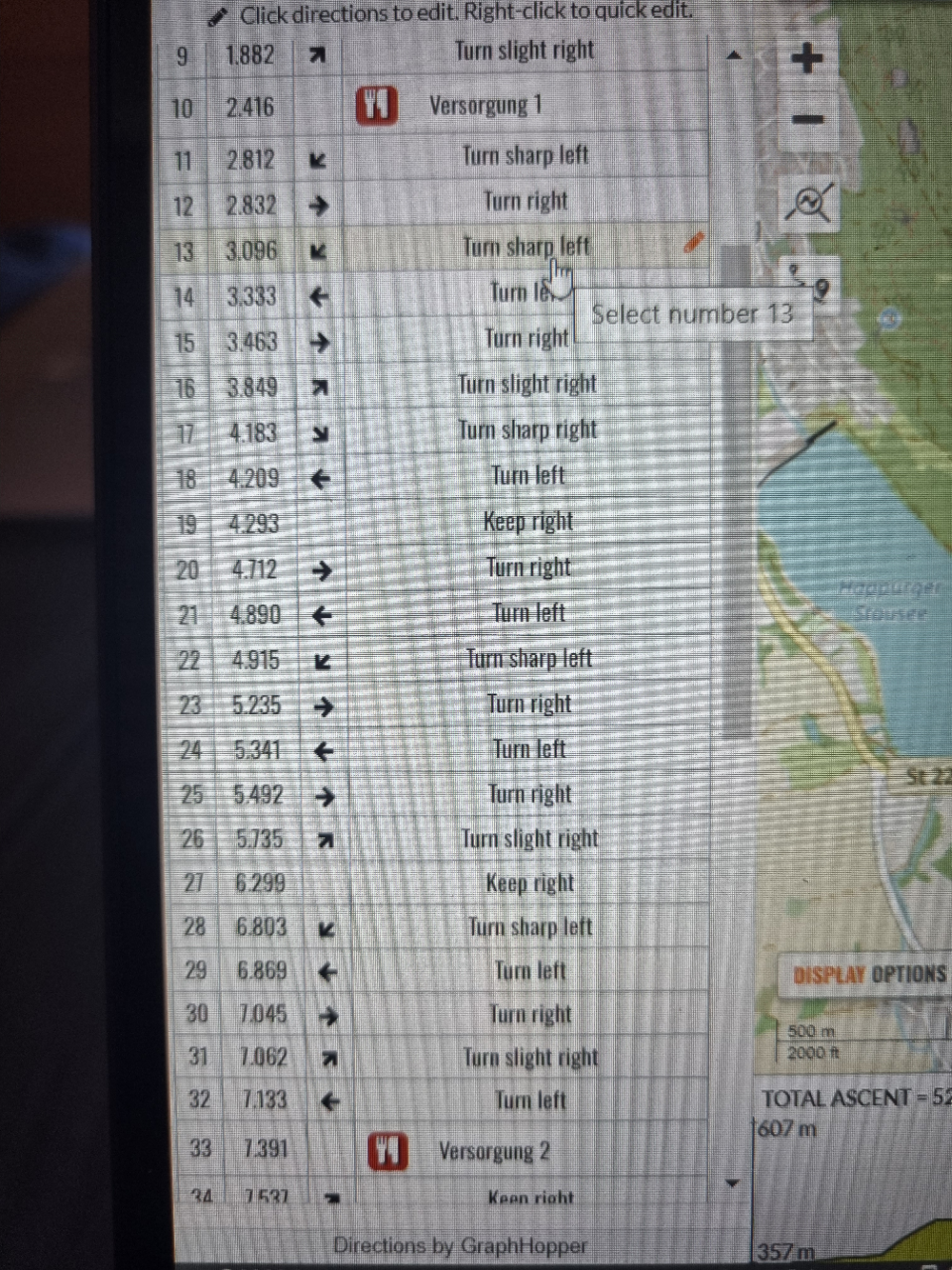
    I created a route in the tool or imported a GPX File and "snapped it to the map" afterwards and it gives me a route with appropriate TBT instructions. You can add, remove, rename all the TBT instructions.

    You can also add points to the route and if you don't give direction but use the label and a symbol, these will be shown in the "Up Ahead" list.

    So the watch can distinguish between TBTs and other waypoints.

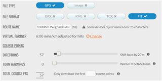
    Then you need to export this as .fit file and configure the handling of these course points to your likings. Especially when the TBTs alarms should appear.

    I need to test these different settings.

    Then copy the fit file per USB cable to the watch into the GARMIN\Courses Folder.

    I need to test it now in real life, if everything is working as intended.

    Thanks

  • Hello again

    I tested today the procedure above (Plotaroute, Snap route to map, Export FIT, Copy to Garmin with USB).

    It's the best solution yet. TBT only where you need it and waypoints working perfect with "Up Ahead" feature.

    I played a little bit with the Export Settings for the Course points and I think moving directions back 10m (first slider) would be best. Second slider is not needed, as the Fenix creates two announcements, one around 20-30m before, the other at the section, anyways.

    Additional benefit of this procedure compared to the TBT by Garmin Connect is, that the annoying black windows at the button, which covers up the area around your position on the map, is not coming up. The popup for the arrows coming from Plotaroute is smaller and does not cover the map.

    Now I would like to see an easy transfer from my Android phone to the Garmin without GC to be happy.

    Thanks