Incorrect OpenWater Swimming total distance and speed

Issue

I did a comparison of the Fenix 7 with my TomTom Adventurer during open water swimming. It appeared that the distance logged by the Fenix (on the watch as well on Garmin Connect) was 2231 m whereas the distance logged by the TomTom was 3.16 km. I know from experience that the TomTom is right, hence the Fenix logged distance is to far to short (29% to short!!).

The speed recorded by the Fenix appears 2.37 min/100m which is 2.3 km/h which is also to low since I swim about 3.2 km/h. Makes sense, since the speed is derived from the distance.

Note that I attached both watches to my swimming buoy (20 cm distance between them) for better satellite signal reception. They were above water all the time with a clear 180/360 degree sky view.

Software version: 8.18

Analysis

Exporting both files to GPX (using own software tools) and showing the activities in Oziexporer reveals  some remarkable issues
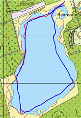
In red the TomTom, in blue the Fenix.

Issues:

  • Some parts of the track do not contain trackpoints, revealing as straight lines. Especially in the northern part, which is the first part of swim and in the south-west corner.
  • Other parts of the track show trackpoints each second, whereas the Setting: Data Recording -> Frequency is set to 'Smart'. Usually it would skip trackpoints
  • Based on this, Oziexplorer reports a distance of 3.05 km for the Fenix, which confirms the 2231 m of the Fenix/Garmin Connect is far to low.

I enclose the original FIT file of the activity: tracklog.studioblueplanet.net/2022-05-17-19-43-02.fit

On close analysis the FIT file contains 1053 erronous [lat, lon] coordinates [180, 180]. This cannot be due to poor satellite reception since the watch was on top of the buoy giving it a 180 degrees sky view 360 degrees around (the best you can get). 

Note that in the conversion to GPX format, I filtered the [180, 180] coordinates out.

The GPX contains 2448 correct coordinates. Assuming each coordinate represents the same distance and a wrong coordinate is not counted in the total distance, this would mean the total distance calculated is 2448/(2448+1053) * 3.16 km =  2209 m, which is pretty close to the reported 2231 m by the Fenix and Garmin Connect.

I checked another Open water Swimming activity in which I compared the TomTom (on buoy) and Fenix 7 (on wrist).
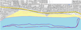
TomTom (blue): 2.17 km

Fenix (red): 2.06 km, 17 malformed [180, 180] lat/lon coordinates

I checked a trail run: 1 malformed [180, 180] coordinate

I checked a generic cycling event: 0 malformed coordinates

I checked a short hike: 1 malformed coordinate

Conclusion

  • The Fenix logs wrong coordinates [180, 180] in all activities. 
    In Open Water Swimming they appear to be numerous. 
  • Calculation suggests that this results in wrong distance calculations on the Fenix, which renders the watch not very usable for the serious sporter!!
    Other posts on this forum also report wrong total distance for other activities.

Advice:

  • Solve the bugs so coordinates are correctly logged
  • Make sure that if occasionally a wrong coordinate occurs, it is omitted for distance calculation. In other words calculate the distance only by calculating the distance between correct coordinates. This gives better results than current situation.
  • gps data. you can swim a mile and if you had a good gps signal at the begining and the end (just 2 good points)

    Fortunately, I do not have such problems. I have in average approximately just slightly under one good GPS point per meter. Despite that, the distance reported by the watch is almost always around 10-20% smaller than the distance of the GPS track. And it is similar (~10%) at running too. Only at cycling the difference is smaller - typically within 5%. 

  • Guys, very interesting discussion. I used the F7 for all my activities. I did about 100 so far and have analysed the FIT files (see table). I compare distances to distances reported when uploading the activity to Oziexplorer, as GPX. The facts.

    • Usually the GPS logging is excellent! My previous watch was a TomTom, which I found pretty accurate. This one is even better, when comparing tracks to roads/paths on a map (and I do not use the clip-to-road features). You might expect that, since it uses 3 satellite systems.

    • Distances reported by the watch/Garmin Connect usually are well within 1% of distances reported by Ozi explorer.

    • During OWS the GPS track seems to be smoothed, which is understandable since large part of the time the watch is underwater without reception (I use *** strokes, resulting in the watch being underwater roughly half of the time). The way to get a decent GPS track is to smooth (this is averaging out the outliers). 

    • During OWS every second a coordinate is logged, even if you choose smart track compression. This seems overdone especially for a smoothed track.
    • During all activities the FIT file occasionally reports erroneous waypoints. They are logged as [-180, -180]. However, at OWS these erroneous points are more (when compared as percentage of coordinates logged correctly). I also found pretty much erroneous points on a hike and during kayaking. 

    • There appears to be a correlation between under reporting distance and the percentage of erroneous coordinates in the FIT. 

    • The worst OWS track (30% missing coordinates) occurred when I attached the watch on my buoy and not on my wrist. Excellent satellite reception and still 30% missing. Maybe the somehow missing of strokes (acceleration) is a factor. 

    Bottom line: when calculating the distance based on GPS coordinates (leaving out erroneous coordinates) would be a great improvement for this issue. 

  • They only have to use 920XT algorithm; yesterday i used my old 920XT and distance is spot on!

  • My new Fenix 7 measures open water swimming incorrectly.  Time is good but distance is wrong.  I have no computer software background.  But before I bought this watch my swim pace was sub 2min per 100m.  Now I can't get sub 3min.  Does anyone k ow if Garmin are addressing this?

  • Does anyone k ow if Garmin are addressing this?

    Most likely not, because many Garmin models underestimate the distance since years, and I did not observe any evolution, despite many updates. The best way is fixing it yourself. If the GPS track seems OK, use the trick with the Strava distance correction (see the details in this post )

  • Or move to other brand for OWS, Garmin simply doesn't care about OWS (and their customers).

  • Same here in Italy... 

    But, silly question: is it possible that 9.33 will solve this?

    As per the release log posted in the forum they "Fixed potential position drift for Open Water Swim activities".

    Makes sense?

    Thanks

  • Didn't notice it; i haven't received final version yet so i can't try this. However i doubt this is the solution...

  • Finger crossed

    Im also waiting the new version. Let's see

  • But, silly question: is it possible that 9.33 will solve this?

    It’s not a silly question. Garmin have been making improvements with OWS since the 310XT. However, as is often the case it’s a step forward for some and a step back for others. There are some who don’t have problems with OWS and obviously some who do. I cannot comment about OWS at the moment as I haven’t been in the sea since June - it’s too cold here at the moment. However, another couple of weeks and I’ll be able to see if there have been any changes since I last swam in June.