Map rendering problem after upgrading to TopoActive EU 2024.20

Hi!

I have recently upgraded TopoActive Europe maps from 2024.10 to 2024.20 on my Fenix 6S Pro (FW 27.00)
I have immediately noticed completely different look of the map.

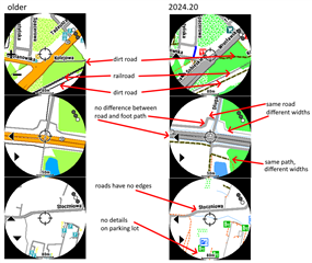
Compared to the previous version (2024.10), I have noticed following differences:
- the maps seem to show no borders (edges) around the streets (except for the main ones)
- the paths (foot/bike) seem to have random / inconsistent width (some of them are light 1px wide line and almost invisible, some of them are strong and dark)
- the map seems to lack the contrast and has become almost monochrome (screenshots look way better obviously as the watch screen is MIP type)
- the foot paths and streets have the same color which makes them not only hard to differentiate but hard to see as well
- the new map is missing lots of details that were previously there (parking lots etc.)
- the new map shows some pavements along the roads as "separate" making the entire map really hard to read (sometimes that path is 1px wide, sometimes is "heavier" than the road itself)
- the new version lacks details like railroads (they are visible as thin line - it is not possible to guess what that really is)

I have prepared an image showing those glaring differences:

Similar changes have been observed by other users - https://forums.garmin.com/outdoor-recreation/outdoor-recreation/f/fenix-7-series/387099/f7x-update-18-16-problem-maps 

Things I have tried to fix the problem:
- I have checked different detail levels (less/normal/high) and different map themes (high contrast, normal etc.)
- I have tried to restart the watch (no change) and switching show contours settings on and off
- I have also checked the MAPTHEMES folder - no changes to the theme files (compared to the backup I have)
- The maps on the watch seem to be the same as I can find in the cache folder on disk (C:\ProgramData\Garmin\CoreService\Downloads\Map\Map_Map.ActiveEU.2024.20\)

The official changelog mentions changes to the color scheme (https://support.garmin.com/en-US/?faq=LR6HR5Xul6A9zoxySC5KM9)
Updated color scheme for roads, parks, trails, and more (all regions).

I do really hope these are not the changes I see on my watch - because the map is currently barely usable for anything.

1. If this is indeed the way the maps are expected to look - is there a way to revert to Topo Active 2024.10 maps (I didn't back them up before upgrade)?
2. If this is not intended to look like this - how can I fix the way the maps are rendered?
3. Are there any changes in map drawing in the latest beta of Fenix 6 firmware (27.76) that could potentially fix the issue?

  • Thank you for the interesting comparison to the previous version! 

    Unfortunately I think that these are intentional changes and it is very unlikely that it will be reverted again. Also I don't know a way to get back to the previous version without a backup. 

    Some background: TopoActive Maps are based on the "open street maps" (osm) project. Most of the inconsistencies you described can be explained by the underlying map data. Let's take your second example. The "same bath, different widths" is not the same path in the osm data. The thick black part is a "track", the thin red part is a "path" in osm. For the "same road, different widths" , the thick left part is a asphalt track, the thin right part is a service road in osm. That being said, the "missing parking lot details" cannot be explained by the underlying data. It looks to be a bug. You could try to report it to Garmin customer support, maybe it can be fixed in the next version. 

  • Thanks for the info and thorough analysis! I have tried to contact Garmin support via website, but I could not send the message (maybe it was too long). I have also sent the same message to [email protected], but I guess it will take some time until it is forwarded to the "right department".

    I have some old backups with Topo 2023.10 - so I guess I can revert to that version. It would be sad to miss the new map data though.

    It would be so nice if we could switch between different ways of rendering the maps...

  • Have you tried a 3rd party map? Maybe you like the style of these better? MapRando is one of the most popular ones: https://ravenfeld.gitlab.io/open-garmin-map/

    Or the talkytoaster maps (but they are not free)

  • Sure, I'm using maps from this website for most of my "mapping needs": https://www.garmin.vasam.cz/download/

    It would but good though to make sure that the "standard ones" are good enough in places where we lack specific additional coverage. Especially that I tend to turn off the extra maps for some of the activities where I don't need the extra details.

  • I find them a little clearer than .10 as they show paths/tracks in red rather than grey the same as roads, power lines, contours etc. But they do need some work. Something like the style of AllTrails and ThunderForest Cycle layer with the clarity of Topo Active

  • I lost the 2023 maps. I am using the maps 2021.21 from a FR955 that I bought last August, on my Fenix 6. Not ideal, but at least usable, esp. in cities that would otherwise be 50 shades of gray.

  • Former Member
    0 Former Member 1 month ago

    I have the same issue with Fenix 7x solar, i did update on OS and maps using garmin express and next day i needed maps and found maps completely useless. At first glans i thought i was problem with update or something, try to reinstall maps, did't change a thing, then i try to upload 3rd party maps and it looked much better, so finally i copied older maps from my friends watch and requested support from Garmin, still waiting results. I suppose i will not do updates from now on :D Moreover, explore app on iphone did the same thing, maps just became unusable. Shame.

    P.s. best maps i found for my watch is here: https://garmin.opentopomap.org/

  • Thanks for sharing. I will stick with firmware 27 and my curent maps then.

  • I'm working on my own style typ for both TopoActive and osm maps as the rendering is screwed on my 965. It should correct any issues on all devices and I can do a 'revert' of the changes here once I find an old topoactive img