What's the best way to put a custom map/route for situational use

What's the best way to put a custom map/route on the watch for situational use? What I mean is, not necessarily a map that I'll hit 'navigate' on so it routes me, but so that I can see the route regardless and where I am on the map.

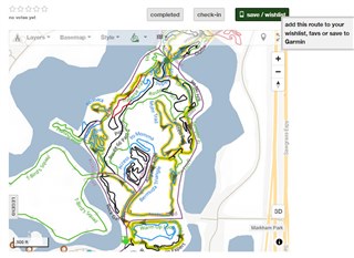
I'm probably not asking this well.. so for example, a map that has hiking or biking trails, like at a bike park (like the one below, I can export this to Garmin as a course, or download as a GPX file and upload to Garmin).

But I don't want to use it to 'navigate' , in the example below there are a ton of smaller trails and I may do them in various order, may repeat some trails, etc.  But I'd like to at any point, be able to reference the map on my Garmin watch to confirm exactly where I am in real-time.

Should I import the map as a course or as a route, and then to reference it while I'm outside... do I have to start a  navigation? (which will interrupt my already existing activity I assume?), or is there some way to just bring up the map without affecting anything?

Or should I start a always navigation just in case I want to reference the map?  

Either way what is best, to have this imported as a course or route?

example

  • In the past when going for a (nordic) skiing vacation, I've used this tool to convert gpx files to a Garmin map file (.img). Then you can activate the map and it becomes an overlay over your other map.

    www.javawa.nl/imgfromgpx_en.html

    You need to be able to create gpx files for all the tracks or find good ones from others to use.

    If I Google on 'gpx to img', I see now that there are more similar online tools.

    If you know exactly in beforehand how you want to go, what tracks to follow, then follow a course is best. But even if you do that, it could be nice to see all tracks in the background to be able to see where you are in reference to all other tracks.

  • do I have to start a  navigation? (which will interrupt my already existing activity I assume?)

    You can always start and stop (and start another...) course navigation without interrupting your activity. 

    Also what phoglund suggested is a good solution. If you have all the trails in gpx format, it is pretty easy to create a map overlay using imgfromgpx. I did the same to create an overlay of MTB routes of my region.