Yesterday i tested my recently bought Fenix 6 pro on a circuit hike.
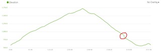
The Start- and Enpoint were the same at 580 m altitude (tracked: 583/593 m), the highest point was at 1748 m altitude (tracked: 1724 m), a difference from about 1168 m.
The reports on the Fenix 6 and Garmin Connect show an total ascent from about 884 m and a total descent from about 1092 m, not consistent.
The altimeter seems to work, at the Start-/Endpoint at 580 m the Fenix shows 583/593 m, on the top at 1748 m it shows 1724 m and at a hiking hut at 1461 m it shows 1450 m, i think thats absolutely ok.
I exported the tracked (with the Fenix) hike as gpx and looked at it with different Apps, in these Apps the total ascent is about 1190 m -1290 m which seems more accurate than the 884 m.
The tracked route looks really nice, the GPS-Signal seems to be really constant.
How could it be that the Fenix calculates obviously a wrong total ascent, but the altimeter seems to work well and the tracked map seems to be accurate?
Settings:
- 3D-Distance on
- 3D-Velocity on
- Record-Interval: 1s
- Auto Ascent off
- Climb Pro off
- Auto-Pause off