Irish Grid Reference

I couldn’t find the answer to this question in Google or this forum. But this is a big one for me and one of the main reasons I bought this watch:

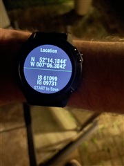
when I look at either IG or ITM, they display as 2 sets of 5 digits

How can I use these with an actual physical map where my local sheet is S and I generally use 2 digit grid (further broken down a further 10) for example S215108 for Eastings square 21 and a half, northings 10 and then 8

hope this makes sense I someone knows what I mean

  • Screenshots would help here. (picture worth 1000 words and all that).

  • I'm not familiar with Irish Grid, but here's a relevant quote from the wikipedia article that might give you some ideas:

    Within each square, eastings and northings from the origin (south west corner) of the square are given numerically. For example, G0305 means 'square G, 3 km (1.9 mi) east, 5 km (3.1 mi) north'. A location can be indicated to varying resolutions numerically, usually from two digits in each coordinate (for a 1 km (0.62 mi) square) through to five (for a 1 m (3 ft 3 in)) square; the most common usage is the six figure grid reference, employing three digits in each coordinate to determine a 100 m (330 ft) square.

  • I actually did read that and the issue that I have is that of all the maps I have, I don’t have one of where I live, so the best thing is going to be going to a spot over the weekend that I know the grid reference of and see if they line up - I’ll post my findings so that others know if they need to

  • Hello Mike, if you look in the Garmin Connect IQ store, you will find a widget called OS Grid Reference by Simon Letts. Once it is on your F6 it is added to your widget list. If you select it, it activates the GPS and (depending whether you are in Britain or Ireland) it will automatically show your position in either OS or OSI grid reference format. Both the Eastings and Northings are in 5 digits but just use the first three of each (you can round up 56493 to 565). The third digit is a tenth of a 1km grid square. So you can then find your position on your paper OS/OSI map to an accuracy of 100m.

    In this example from Colonsay in Britain (which is on OS sheet NR) the widget on the watch gave an OS grid reference of NR 39302 91341. I used NR 393 913 to place myself where the red arrow is...

  • In your settings ('System', 'Format', then 'Pos. Format' for me) you can change to British Grid or Irish Grid. I needed to change mine to make it OS Map compatible for telling me my position.

  • I have it sorted now - thanks everyone - the IG format is correct and gives reference to 1m square - so, my sheet ref is S and grid is 61 (down the hall) and 09 (up the stairs) for a 1km area