Enhancement Request - Course - Directional arrows like F7/Epix2

Hi the community Like for this idea :-)

Garmin, thanks to add this long awaited features to Fenix 6 !

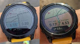
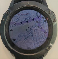
'Added course directional arrows to course lines on the map'

https://forums.garmin.com/outdoor-recreation/outdoor-recreation/f/fenix-7-series/306156/system-software-9-33

---------------------------------

Most important thing, Fenix 6 Series is already capable/compatible, take a look at Round-Trip Course feature by yourself Nerd

Credit : 

---------------------------------

I also post the Enhancement Request under Beta Forum, you can Vote UP !!!

https://forums.garmin.com/beta-program/fenix-6-series/bug-reports/i/public-beta-26-xx/enhancement-request---course---directional-arrows-like-f7-epix2-frxx5

--------------------------------

Older but well discussed public post forum to understand the "bad behaviour" during navigation

https://forums.garmin.com/outdoor-recreation/outdoor-recreation/f/fenix-6-series/191773/why-is-it-so-hard-to-follow-a-self-crossing-course#pifragment-1292=4

  • Hi, finger crossed for me., these 2 ER are Acknowledged

    Somehow, the first thing that i could think of was: :

  • I still remember good old days ( H1 2023) when  some items got a stamp of Ticket Created, which normally means a higher chance of coming true compared to Acknowledged. And we all do know what happened to the majority of items with Ticket Created, don’t we?

  • An enhancement to course navigation, not the directional arrows but something interesting

    ---

    https://forums.garmin.com/beta-program/fenix-6-series/f/announcement/351353/beta-version-26-82---check-for-updates-for-pro-models-side-load-available-phased-rollout

    • Removed the limitation on the number of points allowed in a course.

    ---

    This the result of this Acknowledged enhancement request, Directional Arrows ER is also in Acknowledge status fingers always crossed.

    https://forums.garmin.com/beta-program/fenix-6-series/bug-reports/i/public-beta-26-xx/enhancement-request---course---remove-number-of-points-limitation-like-instinct-2-series

  • I think I have a very imperfect workaround. When creating a course, use the virtual partner to set a speed just a bit faster than your planned average.

    I always create courses and follow them when cycling. I sometimes see a large grey triangle ahead of me (blue triangle) on the course, but never knew what it was. Sometimes I'd see it a lot, sometimes hardly ever, or not at all. If it was on the course just ahead of where the course crossed paths then it would indicate to me the direction of the course.

    I only just found out this is the virtual partner and its location is determined by the average speed set under the virtual partner option when creating a course. Garmin had been automatically setting an average speed for courses I'd created and if I was a little slower than this then I'd see the virtual partner arrow just ahead of me. So now I set the virtual partner to about 1 km/h faster than what I expect to ride at and I can see it just ahead of me and it indicates to me what direction the course follows at junctions where the course path crosses. Obviously, this requires accurately knowing what your average speed will be and if you're faster or much slower than this then you won't see the virtual partner arrow.

    This must get embedded into the .fit file. Maybe somebody who knows how to read and edit them could say if it is possible to insert multiple virtual partner speeds so several arrows could show on the course for different speeds?

  • it's a workaround not a solution or it could be interesting that "Virtual Partner" does not go faster that you like 500 meters ahead :-)

  • Removed the limitation on the number of points allowed in a course.

    I read somewhere that for Instinct 2  this limit had been 50 before the sw change.

    Do you know what the limit is for F6X? I mean in the latest official, 26.0, where the limit is still there.

    I am curious, because i created long courses for F6X, between 50-100 km, I saw in Mapsourse that there were more than 1000 points in the track which was converted to a course by GC during the import process. And I never ever had problems with course point limits.

    So this limit of 50 would be soooo unbelievable for F6, or F5+ or F3HR, which I already used with courses. And if the limit is like 10,000 points then its elimination means nothing in practice.

  • I cannot help you, but let me share with you that two weeks ago just for fun I set VP to have an avg pace of 10:00.  In the first 20 km when I ran I saw no VP arrow, fine. Then I walked, but my avg pace was still between 9:00-9:30, so no VP arrow, still correct. Around at 50 km I had a long break in a buffet, so when the avg pace increased to 10:00 then VP arrow appeared correctly and was a bit ahead of me.

    But later I had some shorter breaks, then my avg pace increased to 10:20 or so. It was at around 55 km. So the time difference between VP arrow and my actual position triangle should have been around 55*0:20, appr. 17-18 minutes. But I still saw VP arrow just like 100-200 m ahead of me. Totally incorrect.

    Moreover I had an extra 1.7 km leaving the course deliberately, 850 m away and 850 m back. My avg pace did not change substantially, but VP got an extra time of like 17 minutes to beat me. But it was still ahead of me within a couple of hundred meters. So for me it seemed that VP was not an object which completed a route/course/track independently from my real trajectory, but was a sort of simple avg pace measure-tool.

    It was the first and only time when I saw VP behaving this way. I found no explanation.

  • Do you know what the limit is for F6X? I mean in the latest official, 26.0, where the limit is still there.

    It's 200.

    there were more than 1000 points in the track

    A coordinate point in the course is not the same as a course point. A long course containing thousands of coordinate points can have very few course points.

    On the F6 I ran into the course point limitation only once - and it wasn't even the longest course I've ever used. I mean in the past I've navigated successfully over courses that were 100 km or longer, but one 80 km course gave me the "200 course points limit exceeded" message.

  • A coordinate point in the course is not the same as a course point. A long course containing thousands of coordinate points can have very few course points

    Sure, but if there are just very few course points then you are either linked to a specific map, or your path has not too many angles (or arcs of different radii, if courses are built not just from straight lined, but from arcs, too).

    Unfortunately I have no knowledge how GC works exactly when it creates a course, but it is evident that GC/GCM does not know which maps are installed on your watch and among those which one you will use with a course. Moreover there are watches w/o maps, but with the feature of courses.

    So I just simply assumed that courses uploaded to GC and downloaded to my F6X were not linked to a specific map. If I was right then in case of having an angle of over a threshold like 5 degrees or 10 degrees a new “course point” has to be used in order to end that straight section and to create a new straight section starting at this course point. 

    If until this point I have not been wrong then it is so strange that a hiking course of 50, 75 or 100 km requires less than 200 course points.

    A new idea came to my mind: maybe the course drawn on the display of a watch uses not just the course points, but all the coordinate points, so it is the reason why the course seems to be precise compared to the roads, trails etc of the map used and to the real environment in spite of having just <= 200 course points.

    If so then course points are in fact not “course points”, but  “turning points” / “directional points” that is  navigating points with turning advices AND/OR “waypoints”.

    Sidenote: I observed that if I do not use waypoints in Mapsource in a gpx file before uploading it to GC then all the “turning points” are used instead of waypoints in the navigation data fields like “Distance to next”.

  • If so then course points are in fact not “course points”, but  “turning points” / “directional points” that is  navigating points with turning advices AND/OR “waypoints”.

    Perhaps not a strict definition of a course point (in Garmin's sense), but here you are very close to the ultimate truth about course point.