Fenix 6X Pro - why do my GPS tracks have straight line sections?

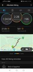
My brand new Fenix 6X Pro watch (Xmas gift) is recording tracks with straight line sections in them. Should I return the watch to Garmin?

I use the watch in the Lake District hills (UK) to navigate planned routes and record my tracks.

I'm using 'every second' and have tried smart recording too. I have also tried GPS + Galileo and GPS + GLONASS. Nearly all the tracks contain sections where my movement was not being faithfully recorded. I was always under a very open sky. My phone was also tracking on one occasion and it had no trouble at the point where the Fenix track straight-lined.

Auto-pause is off.

Any clues? I'm on the point of returning it.  My Garmin eTrex 20x has never missed a beat over many years use.

  • Ah, yes, good point, that might be a consideration too. I have only ever used ‘Walk’, never ‘Hike’ or ‘Climb’.

  • I've been using 'Navigate' and that was generating straight-line sections. I did wonder if the different activities might use a different algorithm however you'd hope that 'every second' meant every second whichever activity you're using. I was out for about 5 hours today in the Lakes. I was tracking with 4 GPS devices at once. I'll see how they compare over the weekend.

    I'll try and replicate Anders tests at some point and report back here. I really want accurate tracks off my 6X. I think the GNSS receiver is generating a perfectly good location, the watch just needs to write the trackpoints to the FIT file.

    PS. Glad I'm not the only OSM fan :-)  Up in Scotland there are lots of OSM paths on the high ground that are unmarked on the OS 1:25k maps, even in honey pot areas like Glencoe, Ben Nevis and the Mamores.

  • I have the same problem when climbing mountains at slow speed with my F6x Sapphire. And I tested F5x and Venu 2 at such slow speeds and they never showed this problem. So it is clearly a software bug, which can be solved. See this thread for details: forums.garmin.com/.../fenix-6x-sapphire-does-not-uptade-gps-position-when-ascending

    And just in case check if "Lock on road" feature is off.

  • Thanks for that Dima. I am also a mountain climber which is why I bought the watch.  To discover that it can't track me properly is very disappointing and has to be a cockup on Garmins part.  It sounds like slow movement is the key and that tallies with the straight-line sections in my tracks. I've got straight-lining on uphill and downhill sections but they tend to be where for one reason or another, I was going slowly. eg Tricky ground or carrying a heavy backpack uphill.

    I've switched off 'lock on road' and anything else that might interfere with the track recording.

    I've just discovered that Garmins BaseCamp software will open a FIT file and allows you to examine every single trackpoint and its associated data.

    I've made a picture of a tracking error here: https://photos.app.goo.gl/SJaG9uqDfr3H9rJVA
    The picture shows the straight line on the map, the FIT file data and a photo of the section I was climbing. I was slowly climbing a snowy/iced ridge and the track straight-lined. You can see the evenly spaced points the watch records. It's obviously wrong. My speed jumps from 0.5km/hr to 35km/hr

    It would be hard to be under a more open sky and I'm certain the GNSS receiver would be able to see plenty of satellites. I was using it in multi-GNSS mode. My smartphone and Garmin eTrex 20x have tracked these kinds of sections no problem at all. 

    The Garmin support article you linked to could be straight out of a comedy sketch. Garmin said  "To avoid this, increase movement speed so position updates more quickly."  Errr no, I think I'll take it steadily thanks!  Fixing the bug would be a much better solution.


  • I am in the Lake District and have never seen these straight lines - I usually walk around Keswick. Buttermere / Crummock Water area but if you on the fells generally GPS conditions are pretty much ideal.

    This is a recent super slow hike with a family member in their 80s so it wasn't speedy! I should say I never seem to see these bizarre problems some people do, so maybe I am not the ideal person to respond, but with several hundred miles and way over 100 walks in the Lake District, I've never had a problem with my GPS tracks. It's very strange!

  • Thanks for caring. Can you share the original FIT file with me so I can examine the individual trackpoints please? That screenshot is no use for checking the track detail. I agree with you. GNSS reception is nearly always perfect in the Lake District. I think it's a firmware issue or similar not a reception problem.

    What settings do you use on your Fenix 6X? Just checking that you are using a 6X?

  • Sure - here is the .FIT from that activity above: https://1drv.ms/u/s!AlVHIini1UNhwQbKYTEuPcOLJWt1?e=IBewf4

    I am using a 6 Pro, not a 6x. Sorry I missed that the thread was about the 6x.

    I use GPS + Glonass, Auto Climb Off / 3d Speed Off / 3d Distance Off / Auto Pause Off / 1s recording

  • That's great. I've got that thanks. As you reported, I couldn't find any of the odd sections that my watch is recording but my tracks have much longer sections where the 'leg speed' is very low. Dunno if that's responsible yet. I also don't know if the 6 uses different hardware to the 6X.

    Thanks for the settings info.....pretty much the same here although my FIT files don't include 'heart rate' and 'cadence' which I note yours does. I doubt that has anything to do with the differences....

    Thanks for your help. I've now sent one example to Garmin to see what they say. Here: photos.app.goo.gl/oqnf6znuJbgExfYq8

  • Strava heat maps imagery on JOSM

    Wow, I didn’t know it was possible to edit OSM data with a Strava Heatmaps layer. I will have to check this out. Do you have to do anything special to see this?

  • Hi. On JOSM just find and enable Strava heatmap imagery in imagery provider settings. Maybe ID has that imagery option, too.