Explore app - courses, routes, tracks…

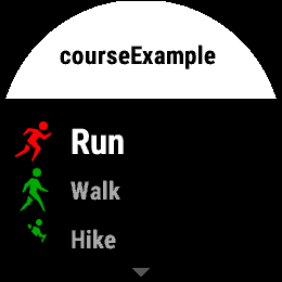
I don’t get it… what’s the difference between the 3 options and why is there only ‘courses’ on my watch?

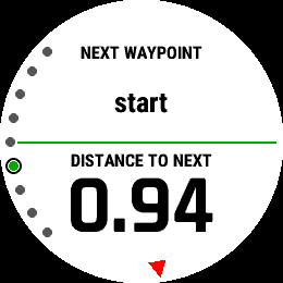
I still haven’t found distance to next waypoint - is not possible to have?

I find the integration between the explore app and the watch to be very unintuitive… and the same goes  for the Explore app itself.

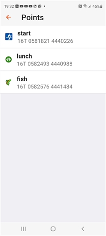
I just want to be able to create, say 3 waypoints, and point my nose in the direction the watch tells me, and the walk. How can I do that???

Top Replies

All Replies

  • Hi all, thanks for all the suggestions and input here. To be honest I still find it confusing and with lots of workarounds and maybes… 

    Still don’t understand why only ‘Tracks’ show up on watch… (copy from course to tracks). 

  • I’ve tried to use Explore on several occasions but keep getting frustrated. The new topoactive maps are better but in New Zealand do not have the backcountry roads and tracks in many places. Where the tracks do exist they aren’t identified. So, while tracks/routes/courses etc can be created it’s quite a guess as to which track is which. When I do manage to create something I’d get it synced to my watch. It’s just not as easy as it could or should be.

    Garmin still have much to work to do on course creation whether using GC or Garmin Explore or whatever. 

  • Fully agree.

    Garmin uses OSM as source for their Topoactive Maps. But for Explore, they are using a map that is several years old. At least for my area. To add to the frustrating, the Topoactive maps on the Fenix use more recent OSM material, so they show different paths. 

    It is overall a little strange how Garmin handles updates to their Topoactive maps. The latest version for the Fenix 6 was released in December this year, but the map material they used for it is approx. 1 year older. I don't understand why they are not using the latest material from OSM. It's freely available, and even  hobby projects manage to update their maps monthly...

  • Although the transfer is done via Bluetooth, transferring the file does not work without an internet connection unfortunately :(. Explore is the only way of an offline and wireless file transfer to the watch.

    You are right. Just tried it, and couldn't transfer the file without internet connection! I was sure I've done it that way before, but obviously I have had connection.

  • You are right. Just tried it, and couldn't transfer the file without internet connection! I was sure I've done it that way before, but obviously I have had connection.

    I read it was working some time ago, but then a Garmin Connect Update broke it.

  • My main problem also, the explorer map is outdated and missing a lot of the tracks that are present in OSM. Also for important tracks that have names you have to pinpoint the map to check the name.

  • I’ll try one more time :-) What’s the difference between Routes, Courses and Tracks? Also, nothing will show up on watch until I Copy as Track. Is that normal? If yes, what are Routes for?

    For this Course, Route or Track - or whatever it is… blue line with waypoints, what app should I choose on my watch to follow, Navigate? Will I be able to see distance to next waypoint?

  • difference between Routes, Courses and Tracks?

    I'll take a crack at this one. It is unfortunate that it is this difficult to work through the terminology.  There are a few threads in the fenix and Instinct forums expressing the same questions/frustrations you've brought up here.

    The naming/functionality even seems to differ between Explore Web and the Explore App (at least Android).

    Let's discuss the app since that is what you show here.  You have obviously created a canoe "course" that requires a portage Slight smile and it looks like you have already modified the start and finish course points with different icons. 

    I have created a similar course with Explore Android named courseExample:

    I modified my course points; names and icons:


    You then need to sync the course to you watch through Explore by linking the course to the watches' default collection (fenix is mine shown in graphic):

    In Explore, select the course, then navigate:

    The Explore screen should look like this:

    Your watch should look like this:

    Pick the activity you like- kayak for example.

    I created a data screen of the activity used for navigation (like kayak)  that shows the next waypoint name and distance to waypoint.  I'm about a mile from my living room to the first waypoint.

    Ignore the conversions to tracks and routes for now.

  • Hey, thanks for that! Very nice. I tried but Explore says to upgrade to latest fw version... okay so I'm on 19.20 (still) and it won't work with that. I could understand if I was on 12.x. But that's GARMIN. They make software like car manufacturers do, if you know what I mean... Anyways, with that method will it be the phone or the watch that does the calculations? I'd prefer to have the watch doing it and be able to turn off phone. Still not sure what Track and Route is in the Explore app?

    Honestly, I'm so tired of GARMIN and their software. I can't even figure out if it's bugs, or just a permmanent state of *** inconsistent software... If Apple ever makes a more sturdy rugged watch fit for outdoor activities, I will jump ship in a heartbeat. Fenix 7 will probably just add to the complexity and sw fragmentation...