Through hike with Fenix / Enduro

Hi all,

After some help to see if either of these watches will help with what I need.  Planning a through hike and really just need some very basic info plus as long a battery life as possible.

Ideally all I want to do is:

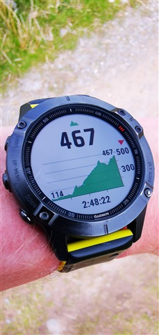
track a route as I walk it (as a record of where I've been, giving me time and distance for the day)

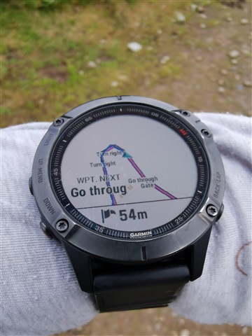
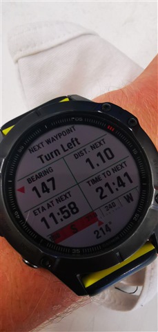
show distance and bearing to a waypoint (next campsite)

display lat/long (for emergencies)

Can I have the main screen set to show this info? When I start a hike can I have the screen show the info for that current hike, plus the info for the waypoint, plus a raw lat/long?

I don't need maps and will turn off every sensor or setting that I can except for GPS. I will have maps etc but would like to have this info available on my wrist.

If this is possible I would appreciate it if anyone could post a pic to show what this would look like.

Thanks a lot for your help.

  • Yes to basically all of this. I run trail runs and ultra's using maps on the watch. You can set POI's and track distance from them directly, or from a third party add-on CIQ datafield. lat/long is inbuilt. I suggest your best bet would be watch a few YouTube videos where people do something like this

    Such as 

                              Maps and Navigation Overview - Fenix 6 Tutorials           

                              Garmin Fenix 6 In-Depth Review For Hiking & Outdoors - HikingGuy.com           

                              Garmin Fenix 5x Navigation in practice around Llyn Brenig in North Wales           

    www.youtube.com/watch

  • Using.the companion app Garmin Basecamp. you can set your routes, define waypoints and upload to the watch. On the watch you can then set proximity alerts to each waypoint. The Hike activity on the watch can have all its data fields customised to as you want them

  • Just curious, the Appalachian Trail is about 2200 miles long and Through Hiking it involves about 6 months without access to a PC and hence without Base Camp.  Much of the trail is without LTE access.  Does the Fenix have enough storage to handle all the maps with waypoints required for such a trail or would it have to be supported by Explore or something else?

  • IN that case I'd just use basecamp to create the files and upload all the files to Explore. Mainly because I find it easier to use a mouse and keyboard to create the files. There's 32gb on board. I have three maps on mine that each cover the whole of the UK.  What basecamp also offers with some maps is (for example) if you had the whole continental US om maps on Basecamp, to just highlight the trail and just have maps for that

  • On my watch is the last six months of activities, also synced to Garmin Connect. I'm a trail runner not a hiker, so a fellow hiker would probably be much better placed to answer your question. But the gut feeling I have is that combined with Explore and some LTE access occasionally to sync data to your GC account this wouldn't be an issue. But I can't imagine many people do six months worth of hiking like this :)

  • Of the nearly 3000 people that started the hike in 2019, 690 completed it.  Those are small numbers compared to most sports, but still impressive numbers.  I forgot to mention in the first post that it is normal to not be near a town for 5 to 7 days at a time due to the remoteness.

    I'll have to play with Base Camp and Explore some...

    Thank you!

  • Sounds like a lot of fun! I've always wanted to do something like this. Here are my thoughts:

    • Personally, I would pick the Fenix 6X (or 6X Solar) over the Enduro, because I feel like maps (showing roads, water, etc) will be pretty important for this activity.
    • Carry a small battery pack and a Garmin charging cable, so you can charge your watch anywhere every 3-4 days.
    • Look into getting a better map than the one that comes on the watch. The Garmin map is fine, but it's probably worth the money to buy a Talkytoaster or similar 3rd-party map. Maybe even get a birdseye subscription and download the satellite imagery around the vicinity of the trail (that will be a lot of work though, for perhaps not that much benefit... but if I had time, I would do it personally)
    • Use something like BaseCamp or Plotaroute to create your route and waypoints, but break it up into smaller segments. I don't know how the AT is, but on the PCT the trail is broken in "sections"... Section A, Section B, etc. So I'd make individual courses for each of those segments, rather than using one large course for the whole 2000 mile trail.
    • Start a new activity each day - don't attempt to record the entire 2000 miles / 6 months trek using one continuous activity. Start a new one in the morning, save and close it in the evening. After your trip, you can combine them into one file/activity if you want. But you're asking for problems if you try to record it as one single file.
    • Set up your Navigation datascreen to display relevant info for the trail. Distance to next waypoint, distance to end, name of next waypoint, current coordinates, etc.

    If I were you, I'd also grab an InReach Mini if you don't already have one.

  • Seconding the InReach… definitely 

  • Thank you for your tips. 

    Already have the InReach Mini which will be used for location broadcasting and weather.  Redundancy for safety is important to me/my wife.  So an old fashion compass, signaling mirror, and paper maps, and phone as well.  Got a battery pack, charger and cables, for phone, watch, InReach, headlamp, etc.

    I agree with one activity per day.  Will look into your other suggests as well.

  • Sounds like you're on the right track with everything!

    Here's how I have my hiking activity set up, if you're curious. Of course, there are many other datafields to pick from besides the ones shown here, these are just the ones I personally find most useful.

    1. Time of day
    2. Elapsed time
    3. Time until next sun event (a ConnectIQ datafield)
    4. Ascent/descent gauge
    5. Temperature (shows value from external Tempe Sensor, if connected, otherwise it's just the internal temp)
    6. Current elevation
    7. Battery hours remaining
    8. Distance traveled

    1. Map
    2. Ascent
    3. Distance traveled
    4. Distance to next waypoint (this shows up when you have a course loaded)

    1. Graphical compass
    2. Calories
    3. Steps
    4. Heartrate gauge
    5. Aerobic / Anaerobic gauge
    6. Exercise load

    1. Elevation history chart

    1. ClimbPro (shows info about the current or next climb/descent)

    This is may Navigation datascreen - it only appears when a course is loaded, otherwise it's not show in my activity. You set it up differently than the others, it is not configured from within the activity, but rather from the Navigation menu in the main watch menu. I have it configured to show:

    1. ETA to destination
    2. Distance to next waypoint
    3. ETA to next waypoint
    4. Name of next waypoint
    5. Distance to destination
    6. Vertical distance to destination
    7. Timer