What use are the free maps fenix 6x??

I was misled. I spend $650 bc I loved the idea of having GPS and maps. The free maps are crap right? I synced and downloaded everything several times. I thought the maps would come with street maps and trail maps. I open the map on my watch and all I can see is the nearby highway? For $700?!!  That's ALL I get?!  What the hell.

I'm supposed to spend $100 for topo maps each?  Do they even guide you when hiking? How?

I can download trail maps from ALLTRAILS after joining the app pro version. So every time I go on a hike I have to ahead of time download the trail from ALLTRAILS on my computer?  I wanted this watch to have street maps and trail maps with more detail and accuracy than the free stuff like Google maps or MapmyRide.

MapmyRide app is FREE and a 100x better than what I wanted the most of out of this damn watch which was detailed maps that I thought were already downloaded. I went to hike for 2 hours on a popular trail and I didn't have *** in the way of assistance from this watch, I came to find out on the trail.

Why shouldn't I be disappointed?  For this money??!! 

  • The free maps work great. Sounds like you've bought a watch from one region and tried to use it in another where it only has the base map which is, yes, basic.  I bought my watch in New Zealand, it comes with New Zealand maps and they're good. If I want super detailed maps of some area though you still need to download them. How much detail of the world did you expect was going to fit into 32gb of storage?

    Go and download the free Maps available for the watch based on Open Street Map and be happy.

    Edit: Attached a photo of the standard map at my current location.

  • I was misled.  I spend $650 because I loved the idea of a supportive and helpful forum to assist me in getting the most out of my watch. Instead I open my browser and all I get is uninformed people who haven't RTFM but sure do have the OUTRAGE TURNED UP TO 11.

    [end Snark mode]

    OK, first thing worth noting is that the amount of detail viewable in the maps. Zoom out and you may only get the highway, zoom in and you will start to see more detail.

    Also, it is worth looking at the map settings, you can adjust the map detail, and also ensure that Draw Contours = On.

    Finally, if you did buy an out-of-region watch, take a look at DCRainmaker's guide on loading free maps. www.dcrainmaker.com/.../how-to-installing-free-maps-on-your-garmin-fenix-5-plus-forerunner-945-or-marq-series-watch.html

  • As above, the default maps (for your area) are actually quite good.

    Apart from having the correct Base Map and TopoActive map for your region, do you have them selected under each Activity type ?

    Activity > Map Settings > Map > Configure Maps > on/off

  • Free maps are no crap. There ar a lot of free osm maps, which are great. And these maps are often updated (if you always want current maps)- the Garmin TopoActive maps are (only) updated 2 or 3 times a year.

    Have you enabled the TopoActive map for your area in the used app and zoomed in? Have you looked, if your bought device came with maps for your area?

    I bought an additional Garmin Topo map Germany (very accurate elevation DEM inclouded, contour lines are shown on the map, slopes are shown hatched in red on the map- very important infos for me..).

  • as everyone has commented on the the maps themselves, I will pick up on "Do they even guide you when hiking? How?"

    Yes they do, and yes they are excellent for hiking. You have a lot of options: https://www8.garmin.com/manuals/webhelp/fenix66s6xpro/EN-US/GUID-D69B4122-8872-4120-9442-8A53F3498ED2.html

    Read the manual to see exactly what it can do but the main options are:

    1) change your data screens for activities where you want to see maps and add a map screen - you can now during the activity scroll to the map screen and see your position. By zooming in and panning around your can see what is around you, and make decisions on which route to take.

    2) download a premade course/.route and when starting the activity launch that route and it will show you the route on the map and provide TBT instructions.You can use the built in connect app, Garmin Explorer (note you can have this live running on your phone while using your watch, or not - useful for creating routes, syncing routes, pulling/pushing waypoints to watch), Komoot (can create/share sync routes directly to connect app/watch), Strava etc - loads of options.

    3) Use offline TBT directions on the watch itself - choose waypoint, POI around you, back to start options etc (refer to link for options).

    4) when running, cycling etc you can get the watch to create a circular route for you (provides TBT instructions creating a route based on the distance you set).

    5) Track me activity - like using this when tracking non activity activities (i.e. take a boat ride / wildlife park ride etc i.e. not being active, but gives me a way of tracking where we went, then I say the waypoints for POI (i.e.spotted grey seal here, dolphins at this point), so I can then match up the pictures to POI waypoints - makes for a real nice storybook of the trip.

    I really do think that once you actually take the time to read and understand a little bit more about what you watch actually can do/provides you will perhaps not be so disappointed anymore. This might be a useful hiking review that highlights most of the navigation features: https://hikingguy.com/hiking-gear/garmin-fenix-6x-pro-solar-in-depth-review/

    PS - re the map detail - I suspect you need to change to high level, and or you have different region, as where I am there is load of detail. And even when hiking in my local area which I thought I knew well, I have been very surprised at the amount of "right of way" paths the watch has identified and suggest as routes which I didn't know existed. So yes the detail is there. It also has no difficulty in regards to showing streets and performing navigation around them; and the "whats around me" feature is pretty accurate and up to date in my local areas and covers around 90% of what is there. 

  • I was misled. I spend $650 bc I loved the idea of having GPS and maps. The free maps are crap right? I synced and downloaded everything several times. I thought the maps would come with street maps and trail maps. I open the map on my watch and all I can see is the nearby highway? For $700?!!  That's ALL I get?!  What the hell.

    That sounds like the only map you have active is the basemap.

    BTW some of the free downloadable OSM maps are unbelievably good. I have one for the UK with virtually every public right of way  on it.


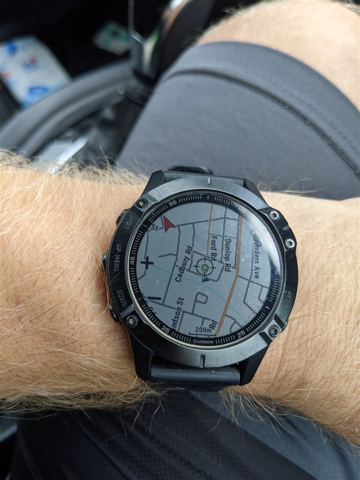
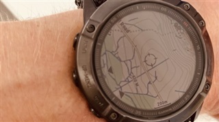
  •   Two examples showing a close up of a quiet area, and one of a local set of streets.

  • Also - not officially supported, But Basecamp Satellite Imagery can also be uploaded to the watch with a cheap ($20) subscription using Garmin Basecamp to add satellite imagery as a map layer.

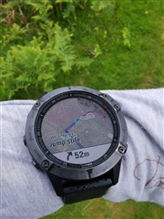
  •  Not the best photo, but showing a) Basecamp satellite imagery and a route with TBT directions. Garmin Connect can create routes, but I prefer PlotARoute. But you can use things like Komoot and the like to create a GPX route and send it to the watch. I've done a whole bunch of ultra's all guided by maps and routes.