Fenix 6X Pro, now an elevation data issue!

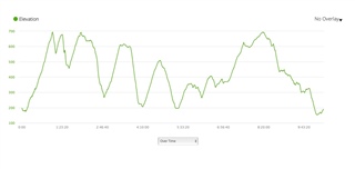
I have had so many issues with my Fenix 6x pro, what a mistake upgrading from the 5x! Firstly a battery which drained overnight, Garmin exchanged just 2 weeks old. Next GPS distance inaccuracies, I run with a club so can compare with lots of other runners data, I’ve learned to live with this by using Strava distance correct. The latest thing now is elevation data! I’ve recently noticed elevation way more than it should be, tonight’s run I recorded over 900ft, everyone else on the same route were between 550-600 which is correct. 3 runners even have the Fenix 6 so maybe just my watch. The only difference is that I run with the tri-HRM, could this affect data? But then I’ve only just noticed an elevation issue? Is this a recent software problem? I’m running 16.70. Any settings tips anyone please?

Regards 

Paul 

  • the usual questions, did you have auto calibrate during activity enabled?  Please describe your settings for any user selectable options related to elevation.  As a first step you may want to turn off any auto mode settings to get a baseline where you're in control rather than the watch.

  • Hi Paul, since 16.70 (and following betas) there is an altimeter issue. I have at least one case running with Garmin that is altimeter related (completely unreliable during fast descents).

    As they at least acknowledged an issue, I can only hope that it going to be resolved some time soon.

  • I've recently started to note some elevation data and compared the elevation in a created courses vs what the watch reports vs what elevation correction in Connect reports. I'm not sure which data is most correct but I suspect that its the data from the created courses. If that is correct my watch underreports the elevation. Anyone knows which is most correct? Or if there is a better way of controlling the altitude data for a created course? 

    My statistics so far:

  • Anyone knows which is most correct?

    I would say that the watch is the most correct. There may be device issues for singe devices and sometimes challenging weather conditions but it is based on a barometer. There is a smoothing applied by the watch, so if you compare the raw data in the fit file the elevation change will be more but correction in Garmin Connect will only make it worse.

    The interesting is to compare the same course over time. The elevation changes I get is very consistent.

  • These are all the same course and except a few outlier it is very consistent. One of few of the outliers may have been caused by me testing Auto Calibration During Activity. I normally do manual calibration or At Start.

  • Thanks for your reply, I'm not convinced yet but you have a point. Is there any good way to validate the elevation of a known course? Runalyze? Strava? Other service?

    I looked at some older data. The 91/158 Created Course is the same courses every time. So, the data should be consistent.

  • Thanks for your reply, I'm not convinced yet but you have a point. Is there any good way to validate the elevation of a known course? Runalyze? Strava? Other service?

    The only way you're likely to get exact correlation is if the services are using the same underlying map/elevation data. Factor in GPs errors and there's always going to be some mismatch. The problem is how much you're going to accept, as you're throwing GPS errors, DEM errors and the like and adding them in quadrature - then allowing for the fact that the GPS errors being random, will change over time and only the DEM will stay static.

    If you run the same course and average them out, you should be able to eventually balance out the GPS errors and get the altitude profile, but it will always disagree slightly with the DEM (which is coarse granular). TobaisL's many iterations of the same course shows this well. Plus, as the course gets longer, these should all start to flatten out. I see far less discrepancy at >10K then <10K. 
     
    For anything that involves a lot of climb, I calibrate at the start like TobiasL. For a course marked 2555m I registered 2574m. Considering there were GPX errors between course and signage, it worked well. I think getting a calibration etc sorted is key to improving this.

  • Looking at your 91's and 158 the following things stand out

    The discrepancy between garmin corrected and created look like they average out

    For the fenix 6x you have an average of (taking the 158 as a start)

    Average corrected = 162m, and average Garmin of under 120m, so I'd say this is calibration showing its ugly head here. For your 6X data the garmin data is running lower, consistently which doesn't suggest a systematic random error but more like a calibration issue?

  • One way to see if there's glitches is look at the elevation profile and see how "smooth" it is. So for example, for that 2574m - I get a very smooth profile, as expected. For the shorter ones, they do tend to be a little spikier but not much.

    But definitely switching on calibrating the altimeter at the beginning helps. It may be worth, for runs less than ~1hr where weather conditions change will be minimised (and hence, a change in ambient atmospheric pressure) experimenting with the barometer settings (changing it from calibrating altimeters to just barometer only) and seeing what happens.

  • AbdersB one good test would be for one of your known routes, calibrate manually just before starting and use the "calibrate to DEM" option. That should set the start altitude to the same value as the mapped course start. Do the activity and see how it behaves.