GPS correction, how does this work?

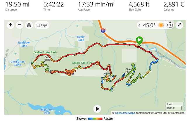
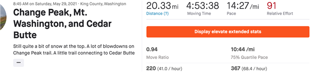
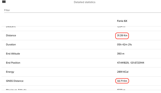
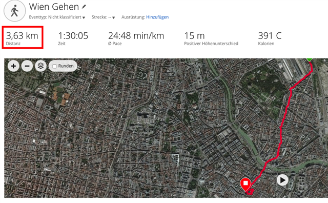
So here’s a question. Not happy with my Fenix 6X Pro. 8 mi known run route the other day recorded as 7.35 mi! Must admit a lot of the route was tree lined with leaves blocking the sky but there were several large clearings. At the 3.7 mi mark watch was showing 3.4 mi but I would have thought once it came into clear view and got a fix my track would jump and update but it never did. So should the track have been corrected by the watch once in clear view? How does GPS correction actually work?

  • I don't know what you mean by GPS correction but there are two distances - the one measured and reported by the watch during the run (7.35 mi in your case) and GNSS distance, which is the distance along the recorded track. The latter, in my experience, is almost always longer and closer to real distance when running outdoors on tree lined roads or trails, but may be too long in urban environment if there is too much wobbling in the recorded track.

    Personally I think Garmin over-filters and over-smoothes the data to please urban runners and avoid complaints like the distance being too long in urban road races. I end up almost always correcting the distance when I run on trails, and for me GNSS distance is typically about 5% longer but still shorter than actual distance. 

  • Thanks, what I mean is that I know what the actual distance is on this particular track. When I was at what should have been around 3.7-3.8 mi my Fenix had only recorded 3.4 mi, in other words my watch had "lost" 0.3 mi, probably due to tree lined and poor GPS reception. However, I ran through some clear view spaces after this but the watch never made up the missing 0.3 mi. I would have thought once the watch knew where I really was through a successful GPS fix my recorded distance would have jumped and eventually recovered the missing 0.3 mi but never did. So in the end, I did a run which is a known 7.8-8.0 mi route and my watch recorded 7.35 mi. I just find this a bit embarrassing for the Fenix!

  • However, I ran through some clear view spaces after this but the watch never made up the missing 0.3 mi. I would have thought once the watch knew where I really was through a successful GPS fix my recorded distance would have jumped and eventually recovered the missing 0.3 mi but never did.

    No, that's not going to happen. This is because of the smoothing that is done in the FIT file.

    So in the end, I did a run which is a known 7.8-8.0 mi route and my watch recorded 7.35 mi.

     If you export the activity as a GPX file, you will get your 8.0 mile correction again.

    You will realise this at the latest when you export your 7.35mi tour as a GPX file from Connect and then import it again. Then you will get the correct distance.

  • I don't know what you mean by GPS correction but there are two distances - the one measured and reported by the watch during the run (7.35 mi in your case) and GNSS distance, which is the distance along the recorded track. The latter, in my experience, is almost always longer and closer to real distance when running outdoors on tree lined roads or trails, but may be too long in urban environment if there is too much wobbling in the recorded track.

    Personally I think Garmin over-filters and over-smoothes the data to please urban runners and avoid complaints like the distance being too long in urban road races. I end up almost always correcting the distance when I run on trails, and for me GNSS distance is typically about 5% longer but still shorter than actual distance. 

    Not sure exactly what you are trying to say here.  The distance recorded in the watch is the GPS-derived distance using the GNSS satellites.  There is no separate GNSS distance.  See the following:

    GPS

    A global positioning system (GPS) is a navigation system that consists of one or more earth-based receivers that accept and analyze signals sent by satellites in order to determine the receiver’s geographic location. A GPS receiver is a handheld, mountable, or embedded device that contains an antenna, a radio receiver, and a processor. Many include a screen display that shows an individual’s location on a map. Some also function as a portable media player. Many mobile devices such as smart phones have GPS capability built into the device or as an add-on feature. Some users carry a handheld GPS receiver; others mount a receiver to an object such as an automobile, boat, airplane, farm and construction equipment, or computer.

    The first and most used application of GPS technology is to assist people with determining where they are located. The data obtained from a GPS, however, can be applied to a variety of other uses: creating a map, ascertaining the best route between two points, locating a lost person or stolen object, monitoring the movement of a person or object, determining altitude, and calculating speed. Many vehicles use GPSs to provide drivers with directions or other information.

    GNSS

    GNSS stands for Global Navigation Satellite System, which refers to the group of satellites that are providing signals from space used to transmit and poisition data. And by definition GNSS provides a whole Global Coverage. GNSS itself includes several positioning terms like GPS, GLONASS, Galileo, Beidou and other regional systems. GNSS is used worldwide to provide a group of satellites to give us accuracy, redundancy and availability 24/7. Often, Satellite systems do not fail, but if they fail through GNSS they find singal from another satellite. Another benefit is a group of satellites, if a connection from one satellite is weak we can get it from another satellite.

    HTH

  • The best, and actually easiest, way to assure the best GPS recording possible, is to allow the watch to achieve a solid GPS fix before starting any activity.  This means starting the activity app, but allowing the watch to "soak" a GPS signal for a few minutes after the "GPS Ready" or all green indicator indicates it is alright to start the activity.

    It is much better to wait a couple of minutes at the start because once an activity is started, if the GPS fix is less than optimal, the watch will rarely "catch up" or fix itself completely - it will struggle with a less than optimal GPS fix for the duration of the activity.  I would suggest staging the activity app - app selected on watch and ready for the Start button - before warming up and then allow the watch to solidify its GPS fix during warming up for a few minutes before actually starting the activity.

    This has always resulted in better GPS recordings for me.

    HTH

  • How do you correct? Just enter the correct length?

  • How do you correct? Just enter the correct length?

    I correct the distance in Strava. On activity web page there is a small (?) link next to the distance. Clicking that link forces Strava to re-evaluate the GPS track and get the distance from it rather than use the device reported distance.

  • Not sure exactly what you are trying to say here.  The distance recorded in the watch is the GPS-derived distance using the GNSS satellites.  There is no separate GNSS distance.

    No it is not. For an experiment, try exporting a track from a Garmin activity and importing it into a third party application. Often, the resulting distance would be different. For me, the distance reported by my Garmin F6X is often shorter, and the delta is greater when running on trails. 

    For example, here is the last outing in the local mountains, as shown in Garmin Connect:

    Here is the same activity on Strava, after applying distance correction:

    All of the 0.83 mile difference comes from the switchbacky part of the run.

    Here is a screenshot from the same activity loaded into http://quantified-self.io - it shows both distances on the same screen (highlighted by me):

    32.71 km is 20.34 miles, so quantified-self agrees with Strava on this one.

  • For example, here is the last outing in the local mountains, as shown in Garmin Connect:

    • If you export this activity as a GPX from connect, and then import this gpx file back into connect, you will get (almost) the same distance as in Strava.
    • You don't need a third-party provider for that.
    • Garmin exports the GPX with the correct distance.
      You can save the GPX locally on your computer, and when you import it into Connect you will receive the correct distance.

    Here is an example without any export to Strava or any other platform. I exported the activity (a city walk) as GPX from Connect ( saved on my computer). Then I imported this GPX file back into Connect.
    Garmin itself turns the actual (too short) distance of 3.63Km into the correct distance of 4.06Km.

    above activity saved as GPX on computer and imported back into Connect :

    This is the behavior of the Garmin conversion from FIT to GPX. Although the FIT file already contains all GPS position points, the FIT file results in a too short distance. This is converted into the correct distance by recalculation during the conversion to GPX.

    The 3.63 km is also the distance displayed on the watch itself. However, it is too short and does not correspond to reality. Oddly enough, older and cheaper Garmin models seem to do it right. THAT is what amazes me.

  • The best, and actually easiest, way to assure the best GPS recording possible, is to allow the watch to achieve a solid GPS fix before starting any activity. 

    Yes, your suggestion is correct. However, it is not the problem here. Here it is the problem of incorrect smoothing of the GPS path in the FIT file. This erroneous smoothing is corrected by conversion to a GPX file, and the correct distance is output.