Fenix 6X Sapphire GPS accuracy?

A friend and I just completed a 4 day hike over 58kms (36 miles) of wilderness west of Sydney. I had a Fenix 6X Sapphire and an eTrex 30, and he had a Fenix 6X Sapphire and an eTrex 20. (We also had well marked paper topographical maps.) We hoped that the Fenix 6X's would fare well enough that we could, in the future, leave the eTrex units at home.

However there were numerous occasions where the Fenix' drifted away from the eTrex' recorded tracks. At one time both Fenix locations froze and ended up more than 200m away from our actual location, whereas the eTrex units kept moving, then over the following 10 mins the Fenix tracks jumped forward to catch up with the eTrex.

In many places we hike, an error of more than 10 metres could result in being above or below a cliff-line, resulting in a lot of wasted time back-tracking.

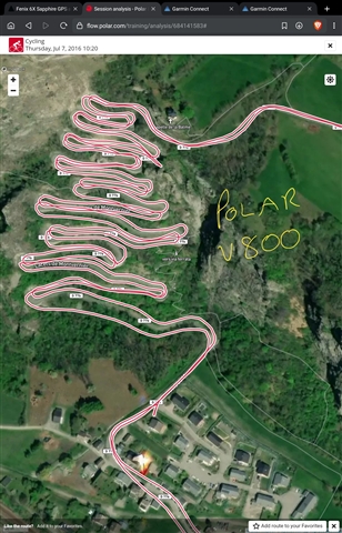
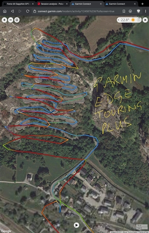
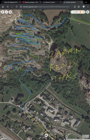
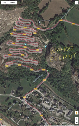
The overlay of the Fenix and eTrex tracks from the 4 days makes for interesting viewing, at least for me. :-)

Has anyone else done this comparison? Does anyone rely on the Fenix 6 online for hiking? Does anyone know specifics about differences in GPS chipsets and performance in these units?

Cheers,

Michael

(Another annoyance was the quality of some of the tracks in the Fenix Garmin topo maps. In one area, it was clear that the track was supplied by someone using a GPS who got lost a few times and had to course correct.)

  • one area, it was clear that the track was supplied by someone using a GPS

    This can happen at any time with the pre-installed maps. The watches have the "TopoActive maps" installed. The data is based on the openstreetmap database. A free database, in the creation of which every person can participate. So it is also never excluded that someone draws a fantasy path that does not exist. The data is checked for plausibility, but it is never excluded there.
    If you need maps with official data of the national survey (which I would recommend in the wilderness), you should install the paid "Topo Pro" maps.

  • At one time both Fenix locations froze and ended up more than 200m away from our actual location, whereas the eTrex units kept moving, then over the follow 10 mins the Fenix tracks jumped forward to catch up with the eTrex.

    I can't say anything about the GPS tracks you recorded in the area you were traveling in, as I can't assess the reception conditions in that specific area. To classify it, it would be helpful if you would publish the track.
    Generally speaking, due to technical reasons (small case/position of the antenna on the wrist etc.) a GPS watch will never be as good (or as sensitive) as a handheld device.
    Your description (jumping tracks) suggests that your fenix simplym lost reception at times, while the Etrex was able to maintain reception due to the better initial situation.

  • Your description (jumping tracks) suggests that your fenix simplym lost reception at times,

    Auto pause on perhaps?

  • Thanks. I forgot about the TopoActive. A positive - they have accurate depictions of cliff edges. The paid maps I have on the eTrex don't show cliffs and the rounding or smoothing method used to make the contour lines makes mistakes at sharp rises/falls, including cliffs.

  • Auto pause was set "off" on both Fenix'. Thx.

  • We hoped that the Fenix 6X's would fare well enough that we could, in the future, leave the eTrex units at home.

    As described above, I don't know how lost the area was where you were traveling. However, if in doubt, I would rather take one more backup than replace one device with another. When in doubt, I would most likely replace the Etrex with an InReach before replacing the Etrex with a Fenix. Good thing you had paper maps with you. Also a compass ? Any technical device can fail. As long as it is not defective, or the battery is empty, you have at least with the InReach the possibility In almost every area worldwide to be able to start a rescue operation (in a cave it does not work of course).

  • Yep we always carry an EPIRB, an actual compass and extra batteries for the eTrex's. :-)

  • This is not a direct answer to the question, but maybe something to consider.

    Firstly, I have compared GPS performance between 6X, 5X+, 3HR, V800, ELEMNT. The conditions have not been super demanding - no cliffs - but sometimes with forest cover or beside a hillside. In general I would say that my 6X performs as well as any other device most of the time, mostly coming out a little ahead. The V800 has the edge in forest, I think, but not in the open.

    As for cliffs (mountains), with half the horizon obscured thing get way more interesting. I used to cycle in the French Alps and have some quite interesting tracks from different devices. The 6X has not been tried in this location (Lacets de Montvernier) but some others have.

    Here are tracks when road cycling with my Polar V800 and Garmin Edge Touring Plus from the same ride up and down the mountain in 2016.


    Here are tracks from the same location in 2018 from my fenix 3HR and Wahoo ELEMNT.


    Maybe things are better now, but the history of Garmin in cliffs and mountains does not inspire confidence.

    Maybe I will return next year and see how the 6X fairs here, if I don't have a fenix 7X by then. 

  • Does anyone know specifics about differences in GPS chipsets and performance in these units?

    Not really, but eTrex uses a high-sensitivity receiver.

    buy.garmin.com/.../010-00970-20

    If you are at the blue mountains, it's a very challenging area for GPS. So you can't expect that a small every day watch is as accurate than a special navigation device.