Here is an illustration of turn-by-turn navigation being misleading (and map rendering not helping)

Here is an example of turn-by-turn navigation not helping at all, and even trying to mislead me.

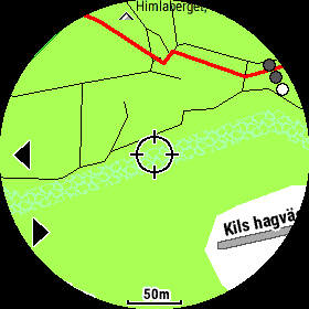
Situation: I am going on a forest road and need to make a turn into a side trail. The watch tells me there is no turn for another 0.26 mi while I am standing right before the trail junction - see the screenshot below:

Yes, the watch does show the forest road on the map, but the problem is that is incredibly hard to see. The road looks more distinct on the screenshot, but in reality it is even harder to see than than those elevation lines, especially considering that the color of the road on the watch is the same as color of elevation lines but it is dotted and therefore has less contrast on the watch, and that I am in a forest (the lighting isn't bright to start with) and it is almost dusk time (which means the screen contrast is much worse than perfect) and my eyesight is no longer that sharp.

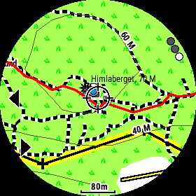
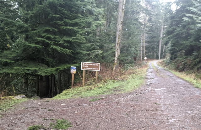
Here is what it looks like at that place - should I go straight or turn? If I follow the watch navigation I am way more likely to go the wrong way. 

And this is already High Contrast map theme. In my opinion it isn't high contrast at all. Yes, I can see the main route really well, but all other details that are really important for course navigation, like other roads and trails, are not contrast enough, and I have hard time seeing them with my declining eyesight, especially when I am moving fast.

What Garmin should really have done is making those bolder in high contrast mode. Also, if turn-by-turn navigation cannot prompt turns reliably, perhaps it is better to not have it at all, and instead give me a way add turn points myself. I know I can use some workarounds to achieve that, but Garmin software should be better at supporting that.

  • This is where 3rd-party maps can help you a lot. The built-in maps are pretty good, but the OSM, TalkyToaster, etc., maps are often much better. Thankfully Garmin is one of the few (maybe the only?) watch manufacturers that gives us the ability to freely load whatever 3rd-party maps onto it that we want. So if you're not happy with the detail and accuracy of the factory map, give it a go with one of the other options available.

  • I agree. I decided to upload 3rd party maps even before owning my Fenix. Never moved a step with native Garmin maps. Based on your country you'll find excellent maps for free (donation is welcome).

  • That is a telling example. And I have had those experiences myself. Like others in this thread, I have downloaded other OSM maps, that are more suited for my needs, and also with a different level of detailing.

  • I've done two things to overcome the shortcomings from Garmin maps and Connect Course Builder, but as  says the Garmin watch is fantastic in the way it gives us a lot of flexibility.

    1. Garmin maps (.IMG-files) give us the possibility to change map symbols, even redraw how path lines should look like. That's described in the embedded TYP file inside IMG file. See below Garmin map example and and a map with my own TYP. The same paths, but not exactly the same zoom level.


    2. I use another route-creating service than Garmin Connect where I can go through the suggested turn-by-turn course points and add/change/delete when appropriate.
  • Would you mind sharing a "how to", or possibly a link on editing the TYP file?

    Thanks

  • You can try my TYP file first, just to test another TYP and then you can go on modifying it for your own needs.

    I really need to update mine, so I write it down as I do it myself.

    (This is for a windows computer. No idea what tools available for Mac.)

    1. Download an OSM map of your own choice. I've been using this site lately. Update maps really often. https://alternativaslibres.org/en/downloads.php Download your country map File for GPS/topographic. 
    2. Change filename to something describing for you and if you want a special name to pop up on the watch, use GMapTool  to edit "Mapset name".
    3. Download my typ file from here and save it to the same folder as your img file.
    4. Download and start this small and really easy tool, TYPchanger
    5. Drag your img AND my typ file into the TYPchanger app. Hit 'Change' button. Wait for Done.
    6. With GMapTool you can double-check that the typ is changed. Not necessary though. 
    7. Drag your new img file into the Garmin folder of your watch.
    8. Disable Garmin maps and enable your new map in every activity/app on the watch you would like to use it in.

    If you would like to edit the typ file, I use TYPviewer app.

    All these tools are really old, but they do work:)

    (If you use another site to download OSM, It's important that the file you download contain a TYP-file from the beginning. TYPchanger does not work otherwise.
    You can check the downloaded file with GMapTool. Drag img file into it and tap 'Info' button. You should see a TYP file in the file list like you can see above in point 6)

  • Great! Thanks a lot. Will absolutely check this out. Much appreciated!

  • Looks very obvious to me that you should bear left at this point. The contour lines back this up. It's a map. On a watch. There's little point in blaming Garmin if your eyes don't work. 

  • Yes, it is pretty obvious when looking at a nice big screenshot on a computer screen with excellent contrast.

    Now imagine having that image smaller, with much less contrast (little reflected light and sapphire glass glare), slightly blurry, and while running. You can clearly see the fat course line and the arrow below that tells you that the next left turn is in 0.26 miles. What is so obvious about having to bear left? There are plenty of people who are older who have less than perfect eyesight, and I am unfortunately one of them. Believe me, without stopping, in a dim light I can't really see contour lines or the thin dotted line for the forest road - not at all. All I can see is that I am on course and there is no turn for another quarter mile.

    Garmin could have made it better in two ways:

    1) Either figure out actual turns by looking at the routable map when generating turns or not generate turns at all and give me a way to do it myself. As it is implemented now, the process of generating turns is not optional - it is forced by Garmin Connect but it is quite dumb for anything other than roads with perfect 90 degree turns. On one hand it generates tons of useless turns for every sharp bend of trails (and you get them every 30-50 meters). On another hand it often misses real turns like this. Often!

    2) This map theme is called high contrast. Make it actually high contrast! Figure out a way to make important navigation elements on the map bolder. There are plenty of older people who still get out to hike or run on trails! And this is supposed to work by glancing on the screen while you are on the move. 

  • its a watch with a 4cm screen, get a bigger device like a hand help GPS unit that is properly backlit.

    If its near dusk and you cant see the screen you should have a headtorch on anyway, so use that to light the watch up, it works really well with the F6 as it requires external light.

    Go get an eye test and get better glasses. I am 63 and wear glasses to read the bloody watch. annoying but a fact of life.

    Carry a laminated map and compass and know where you are at any time, like you should do. A watch should be a back up.

    From your picture you aren't at a turn, you are at a fork and the watch shows taking the left fork is the correct thing to do.

    I think you are expecting too much from a tiny gadget strapped to your wrist, and really that should only be used as a backup to your primary navigation tools.