Waypoints

Hi,
I Recently bought a Fenix 6x pro (again) and crested a course on connect with a few test waypoints to see if it works ok.
I sent the file to the new files folder to do away with the turn by turn notifications that come across by sending to watch.
When out on the course the waypoints showed and distance to next etc was correct and at the waypoint the watch notified for the waypoint however it only showed it in the lower part of the screen and was just a symbol not the text I had written.
Last time I had a Garmin it used to show the notification full screen and displayed the text I’d written.
Am I missing something to get it to do this ?

Thanks

  • yes - i need to have them as seperate waypoints. i tried to edit the waypoints referring to your next post but without success. (symbol "information" replaced by symbol "summit") they are still not shown on my garmin watch :-(

  • Can anyone explain me how to do this, relatively simple, step by step, and what software (Garmin web, connect, explore, other?):

    - create a course,
    - add to it custom waypoints (water, food, etc.),
    - upload it to watch (which format file, how).

    BUT I'm not interested in TBT notifications, only waypoints.. and more, I want to see them on the map along the course?

  • I would use Basecamp for that  I was put onto these Basecamp tutorials by a fellow poster.  www.youtube.com/watch

    Basecamp can create tracks, create separate waypoints and then send the lot en masse. If you purchase the satellite imagery, it can also upload the appropriate imagery

    Basecamp can create (with the route) flagged separate points (the watch calls them Saved Locations) you can create along the route. Although if you don't want to use that and stay with PAR :, you can edit the directions in PAR and add text labels which DO display on the map ( I use these myself)


     if you need separate waypoints as well, you could either use PAR's text labels or import the route into Basecamp, (creating a separate folder to store route and waypoints) and use that to create the separate waypoints as well.

    For both of you - Basecamp creates great tracks (use tracks not routes - there is a difference, basically with tracks you're setting your own notifications etc, routes use the underlying map to route you - tracks are for when, like me, you go off road and there's no underlying routing info. .... so if you stay on roads, you can use routes, but if you do ultra's etc and go over footpaths, through fields, rivers (!) etc use tracks!!)

    There's a great set of videos by that channel that will quickly get you very comfortable with Basecamp

    Basecamp Intro/Setup: https://www.youtube.com/watch?v=r5pDwciUEk4
    Routes: https://www.youtube.com/watch?v=r5pDwciUEk4
    Modifying rotues: https://www.youtube.com/watch?v=RIkjsTVsSVM
    Waypoints (!) : https://www.youtube.com/watch?v=3sdfSJ9kzUs

    There's 17 videos in all in the playlist: https://www.youtube.com/watch?v=p8RfVSx6QQY&list=PL7SnEAaQ4kJh7gnOHW_IsXDRyauzcFgK7

  • There's a lot of ways of doing routes/waypoints etc. Sometimes I think this multitude of ways is a bonus, others I think its confusing! But my logic is thus:

    If I just want a simple route to run too, no bells and whistles. I'll do it in Connect. For a simple 5km road route, it's quick, simple and does the job. Plus I can use the popularity routing data.

    You mentioned Garmin Explore. To me, it's sort of a halfway house between Connect and Basecamp - but I didn't get on well with it.Thats not to say it may not work for you. It does have collections so you can group activities tracks and waypoints together. It has promise, but still think it's a bit weak.

    For anything more complex, I have two choices, and both do things well

    Basecamp and PlotARoute both allow for more complex routes, routing, waypoints etc. Both basically do the same as each other, although Basecamp has one advantage - if you connect the watch to your computer, it can manage the routes/waypoints and send them to the watch direct. PAR needs export (or PAR Premium to sync directly). Plus Basecamp can upload maps to the watch as well.

    It's not ideal, and I wish that Garmin would beef up Connect's routing etc in line with PAR. It's a weak point, but if you're unhappy send Garmin (via their websites) your views - the more of us that ask for better apps for this the better/.

    But for now, I'd say try PAR, try the text on map for waypoints etc (if you don't want any TBT bar to these points - PAR can delete all other directions and leave you just to these points). I tend to use those datafields I listed above for checkpoints, add text on maps only for hazards that warrant a lot of attention (like rivers, cows etc).


    For both of you, you'll find what works best for you by trying them and see which feels more "you". If you don't want ANY TBT's or distances etc except for these designated waypoints, it can be done. I tend to PAR because I've done more routes in it, and I'm a little more comfortable with it. But I still use Basecamp if I want to add separately flagged waypoints (the flags on the map).

    SO Basecamp for me tends to be not only a add-on app (to add on extra bits) but also a route storage medium. I have folders set up with activities etc I am considering/have done. An archive, so to speak.

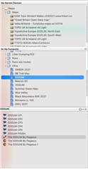
    As shown below - my Basecamp - the top lists all the maps I have, the mddle is my folder structure with runs, and ultra's I've either done or want to do. Here you can see I've selected the EDDUM 2021. The bottom shows what's in that folder. The flag icons are separate waypoints that show on the map separately to the track for the event (which is in grey highlight) and below that is two sets of  Basecamp Satellite Imagery. What I do like about Basecamp is that you can create a route/track, select it and then with a few clicks download just the Basecamp imagery to cover the area.


  • And then how do I upload it to watch? Does basecamp have an upload button or I have to do it manually (by coping the file)?

    Is there other way to upload tracks (course+waypoints) to watch than using copy files (which is suuuper annoying)?

    Would it be possible to create a track using ex. alltrails, komoot, then save it to what (gpx, tcx...) and than upload it by bluetooth, can garmin explorer do this?

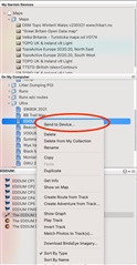
  • 1) Yes Basecamp has a "Send to Device" option, will do it automagically.  You can select a single file, or a folder of files, right click and send to device (as it's PC/Mac, connect your watch via cable)

    2) Yes explore can send via BT link. I haven't used explore much, but I'm sure it can import tracks. GPX is normally the best way to copy tracks between apps, though I find FIT better for manual copying

    (Yep - Explore can import - https://support.garmin.com/en-US/?productID=614327&faq=JB2oAqEgCU17c7IqE3yHvA&tab=topics)

  • Also if you buy PlotaRoute Premium, it can send it's routes via Garmin Connect (and hence, via BT) and seems to keep all data sending over.

  • My thoughts in a nutshell.

    It's still not optimised. I think Garmin still hasn't optimised it for smaller screen devices like watches (and it shows because there's a few apps to choose from depending on use Connect/Explore/Basecamp)

    My advice: Try Explore, Basecamp and PlotARoute. Do some simple trials to get what you want (before you use it for real). What works for me, may not work for you -  but it can be done. You'll find what works well for you, and stick to it Slight smileThere are some great third party CIQ fields which can help fill gaps too.

  • Thanks a lot for your help -  I appreciate that very much.... i tried to use basecamp in the beginning but unfortunately the windows version is somehow unstable when sendiing tracks with waypoints to the watch. also it needs a lot of time when connecting the watch to basecamp until the maps from the watch are downloaded to basecamp (this btw happens all the time i connect the watch to basecamp Worried ). so i was hopeful that PAR can easily replace BC to create tracks including waypoints. i will play a liitle bit with PAR and your tips to find out if it will work for me.... Thanks again Slight smile

  • Yeah the indexing is SLOOOWWWW. but fortunately it's a one off. What I did, is when my watch was VERY low on battery, I then connected it to the PC and let it index, so it charged and indexed at the same time. BC is a lot better these days so if you can get past the indexing hopefully it'll do the business.