110m ascent... on a flat track

Hello all,

I know there are many threads about elevation & ascent problems on the Fenix 6 but I think maybe my problem is just caused by a wrong setting.
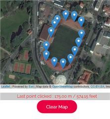
I made a 10km time trial on a flat 400m track last saturday, and the Fenix 6 measured a 110m ascent...

Has anybody any idea of what is causing this false measurement ?
I was on auto calibration during activity.

connect.garmin.com/.../5975231805

The (falsely) detected ascent seems repeatable on each lap, and there was a moderate wind, which could have maybe affected the barometer reading ?

What is even stranger is that when I use Altitude correction on Garmin Connect the ascent goes from 110 to 130m ! Smiley
Probably the DEM map is completely wrong...

Top Replies

All Replies

  • My question due to the external sensors is that there are some correlations in the altitude and cadence spikes. I would try a run without the external sensors.

  • could be due to sweat in baro holes.

    We are all entitled to speculate what causes issues but I just cannot see this being the case. Just how much sweat do people see flying off the back of their hands when training? If you wear the watch properly how can you possibly flex your hand back to obscure the barometer ports, and keep them flexed and the ports covered. I swim 3 or 4 times a week (approximately 10km) with each stroke potentially 'forcing' water into the barometer ports yet my altimeter reads fine.

    Something else is going on that Garmin is apparently struggling to resolve for some people.

  • Is this a one off issue or is it recording the same data error all the time for the same bit of track?

    I don’t know whether it’s correct to assume that any GPS watch will never report a bizarre value ‘occasionally’, and if it does once ina blue moon, then you just put it down as an outlier. I’ve had Suuntos and Garmins for about the last 7 years or so, and each has reported a bizarre time or elevation once, so I’ve just put it down to random GPS anomalies.

  • I traced your route on Google earth and it showed the altitude varying by about 6 ft from the low spot on the track to the high spot.  Don't know if that's entirely accurate, but its possible the track isn't absolutely flat.  The big question is did you show a similar 110m descent so your net gain was approximately zero?

    With 1m resolution the watch is going to drift a bit over time, but those drifts should average out closer to zero.  So, if you show 110m ascent and 110m descent, then that's probably more or less normal, especially if the track isn't absolutely flat.  I run on a closed loop course that has about a 15ft elevation change from one end to the other, and at the end of my runs I show an ascent about equal to the number of laps times 15ft, but the descent is also about the same value, so the net elevation change is usually 0-10ft when I subtract the descent from the ascent.

  • I traced your route on Google earth and it showed the altitude varying by about 6 ft from the low spot on the track to the high spot.  Don't know if that's entirely accurate, but its possible the track isn't absolutely flat.

    This can't be right. 6 feet? That would make the track visibly inclined, and would make running on it very peculiar. Certainly an inaccuracy in Google earth's DEM data.

    With 1m resolution the watch is going to drift a bit over time, but those drifts should average out closer to zero.  So, if you show 110m ascent and 110m descent, then that's probably more or less normal,

    110 m elevation gain on flat surface over 10 km is not normal. My F6X gets closer to 10m elevation gain per 10 km on flat terrain.

  • 6 ft (2 m) difference in 100 m (the straight portion of the track) would be 2 % incline. And based on quick googling, 2 % seems to be the upper limit for flat roofs (enough incline for rain drainage, but still perceived as "flat"). So I wouldn't count out the possibility that the track is just not completely flat, and the slight difference just accumulates during 25 rounds.

  • I got a rid of the brand going back to Suunto

    Can you post the Suunto's elevation profile when you repeat the activity please, preferably under comparable time / atmospheric conditions?

  • The tracks seems quite flat to me when running on it, and elevation seems to be 175m all around it (checked on this site), I'm confident I would feel it if there was a couple of meters difference on one side :)
    The elevation loss is also estimated at 108m which lets me think this is a calibration issue.
    I'll try another run with calibration only at start of activity to check if it makes any difference.

  • My question due to the external sensors is that there are some correlations in the altitude and cadence spikes. I would try a run without the external sensors.

    as far as I know (maybe I'm wrong?) pace and HR sensors do not interfere with elevation data. There is indeed a barometric altimeter in the stryd sensor to detect instant elevation change, but it does not transfer data to the watch.

  • 6 ft (2 m) difference in 100 m (the straight portion of the track) would be 2 % incline. And based on quick googling, 2 % seems to be the upper limit for flat roofs (enough incline for rain drainage, but still perceived as "flat"). So I wouldn't count out the possibility that the track is just not completely flat

    Are you serious? This kind of incline would mean that a person who is shorter than 2 meters would have to look slightly up to see the other end of the track! I'd love to see a track like this.