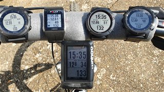
-
GPS
-
GPS + GLONASS
-
GPS + Galileo
Out of the three options, which one is best? and most accurate for United Kingdom and Europe
GPS
GPS + GLONASS
GPS + Galileo
Out of the three options, which one is best? and most accurate for United Kingdom and Europe
There is no absoluty answer. You need to try each settings.
For me (in switzerland) the best is only GPS
because it’s will be my area every country is different for GPS signal and set up.
Too an extent, but as I mentioned, there are changing factors that determine what may be the best configuration at any…
I’m from Surrey Data recording you use smart or every second
Makes no difference, recording is the same at every second just whether the data is saved or not.
The fenix 6 gps is good enough, it’s not perfect but a good balance on accuracy and power consumption.
Depending on what you use case is, you may or may not see any issues but don’t expect perfect lines on a map, the ones you see are that are better typically from power hungry gps chips or post processing to make it look nice.
its gps, you are traveling at a slow speed if not on a bike/ski slope so expect gps pace jumps (already averaged over 5-10seconds and in blocks of 5seconds) and wavely lines on the post run map
So you use GPS + GLONASS and this is the best option for you for pace and accuracy ? we live in UK closer to each other and I’m find out GPS + Galileo it’s more accurate check this option next run and test because now Galileo Satellite is in full operating system they launch new satellites
See this
www.gsa.europa.eu/.../galileo-european-global-satellite-based-navigation-system
From page 42 of the Fenix 6 owners manual:
Improving GPS Satellite Reception
Frequently sync the device to your Garmin Connect account:
Connect your device to a computer using the USB cable and the Garmin Express application.
Sync your device to the Garmin Connect app using your Bluetooth enabled smartphone.
Connect your device to your Garmin Connect account using a Wi‑Fi wireless network.
While connected to your Garmin Connect account, the device downloads several days of satellite data, allowing it to quickly locate satellite signals.
Take your device outside to an open area away from tall buildings and trees.
Remain stationary for a few minutes.
So it looks like the watch does download gps position data in order to acquire satellites faster.
I use a IOS app called GNSS View. It shows what nav satellites are overhead at any particular moment. It my region which is Hawaii HPS is just fine. But like all have mentioned before many variables come into play. Since I most use my nav on the open ocean I rarely need anything but GPS. If I plan to trek through the jungle tho I may use additional GLONASS.
I’ve used GPS plan, it’s a great app and shows more than just coverage but the quality of the signals. For me regardless of the provider, the general coverage and quality is great, only at brief 15 min windows it shows there would be a low number of satellite coverage or low satellite coverage quality where you see the sudden spikes in pace to movement from the run/walk/hike path as the satellite move over the horizon and the coverage or quality of the remainder is poor
do also consider the following - the things related to the watch rather than constellations and no of satellites:
- accuracy of the gps chipset
- hardware & software implementation
it was several times said that garmin optimized the chipset for gps + glonass usage - hence this is the default factory setting. obviously, depending on several factors gps alone or combined with galileo might work better, but unfortunately it's a consumer device inheriting obvious limitations. my guess - it will take another 2-3 watch iterations (fenix 8 :D or garmin 965 ) until we'll get even better accuracy. with the latest gps fw i get pretty decent tracks (ok - decent to good, and consistent) with both glonass and galileo here in eastern europe (romania) and i'm very happy with that ;-).
so 'best option' is also pretty relative :D - but for utter accuracy (in proper training), the best solution is to run laps on a track using a timer.
I live on the London/Essex border and my experience includes Polar V800, Fenix 3HR, 5X+ and 6X Pro Solar.
I have found tracks from GPS only or GPS+GLONASS to be the most accurate in terms of tracing the path taken. I have only tried GPS+GALILEO a handful of times because I have never been impressed with the results. FWIW Garmin has chosen GPS+GLONASS as the default setup (I think) and maybe the watch is optimised for that combination.
I think ththere is little difference between GPS only and GPS+GLONASS in good conditions, but I figure that to use both systems is like having belt and braces in case the satellite view is poor from my location at the given time.
I can't really comment on accuracy of distance and pace as I use Stryd when it matters. I have conducted multiple tests when walking the dog and differences are there, but usually not enough for concern - for dog walking at least ;-)
Sample testing setups below....
.
Example from today's dog walk. The track shows some bias to the left at times, with the watch on the left wrist, but it is a good track all in all. Dog walks can be tricky, with stop/start to pick up the ball, turning to throw the ball etc.. The absence of random tracks in this scenario is very positive in my opinion.
Just to add to what others have said.
Someone please correct me if I’m wrong, but when GPS + Glonass or GPS + Galileo is enabled, the watch will only receive radio signals from the GPS satellites until the signal is too weak to provide an accurate location, for example when running through a forest, then it will attempt to lock onto Glonass or Galileo to establish a fix. They don’t work in combination to provide enhanced accuracy.
Since you can set individual satellite settings for each activity, a good way of using the watch is to set your run activity profile to GPS only where you’ll be running on open roads and pavements, and set the trail run profile to GPS + Glonass where you’ll be running off road through trees etc.