During a course navigation waypoints never come up

My observation is that navigation to waypoints (course points?) on a course seems to be utterly broken. Basically, not only waypoints aren't shown on the map, but they also never come up in a notification. To be more exact that does work sometimes, but more often that doesn't work.

Here are my two most recent experiments.

1) I had 4 waypoints generated by Strava for starts and finishes of a couple segments that I had on Strava route. Strava course was successfully synced to Garmin Connect using the recently introduced synchronization of courses from Strava (hurrah!). The 4 generated waypoints do show up in Garmin Connect correctly 

I then synced that course to my Fenix 6X and went on the run. During the run I could see only the first of the 4 waypoints because it just happened to be at the end of a straight part of the route. I've never seen the other 3. Well to be exact, the 4th one did pop up a notification briefly but I couldn't see it coming. I didn't even see notifications for the 2nd and the 3rd waypoints.

My suspicion is that those waypoints got obscured by TBT navigation instructions that Garmin Connect inserts in the course as special waypoints, I think. The course was super zigzaggy and had probably at least of 100 of TBT instructions, many of which were close to those original waypoints I had on the course. 

My observations:

1) I couldn't see waypoints at the bottom of the map screen where upcoming turns are normally displayed.

2) I also couldn't see waypoints on the dedicated navigation screen that has "next waypoint name" and "distance to next" fields. Most of the time the name of the next waypoint was blank there and the distance to next showed distance to of one of the more than 100 turns. This is a known issue, but with so many completely useless TBT instructions on that trail, not having the information I actually wanted and seeing distances to turns every 100-300 feet (30-100 m) seemed especially broken.

OK, back home I made another experiment - a very short course near my home with just a few turns and two waypoints - I did that course entirely in Garmin Connect.

Then I went on a slow walk on that course, carefully looking at the watch. The result of that was:

1) Both waypoints never showed neither on the map, nor as notification popups, nor on the dedicated navigation screen where I have upcoming waypoint name and distance to next waypoint.

2) To be more exact, the name of the first waypoint did show in the "next waypoint name" field, but only before I reached the course start point. Once I started going on the course, the name of next waypoint was cleared and never updated with any of the two waypoints.

One thing that I've noticed is that both of these waypoints are very close to turns. Perhaps the watch has some logic that prevents too many TBT notification to show one after another if they are too close to each other. My suspicion is that it treats user defined waypoints the same way as TBT waypoints, so perhaps having turns close to waypoints prevents waypoints from ever showing up.

TO WHOEVER AT GARMIN THAT MIGHT READ THIS:

---------------------------------------------------------------------------

An easy short term solution would be to add an option somewhere in Garmin Connect on a course page to let user choose whether TBT waypoints should be inserted. In my opinion, on many trail runs TBT instructions are useless and even distracting. I don't need a turn notification for every natural bend of the trail. At the same point it seems to sometimes miss TBT instructions where they are actually needed. So overall having TBT is a useless feature for trail running. I'd rather have my own waypoints.

A better solution would be for the watch to distinguish user defined waypoints from TBT waypoints. The watch should still show next real waypoint on the map (or perhaps all waypoints) even if there are turns in between. "Distance to next" field and "Next waypoint" field should reflect ONLY user defined waypoints. The way these fields work now is absolutely broken.

  • Haven't tried but for cycling there is not a such option.

  • You're right. Only works for running, trail running and hiking. Just tried it.

    Strange. But maybe it's just been implemented and will be added for cycling later. I don't remember seeing this option for running last time I looked or seeing it mentioned as a workaround anywhere.

  • That's super weird that it is only available for certain activity types. I really don't see any possible reason for that.

  • Hello, I am struggling with the same issue - preparing for several months thru-hike, I want to see on my Garmin Fenix 7 certain points like water source in the "up-ahead" screen when running course. Garmin explore app doesn't know to do it, just Garmin Connect. I didn't succeed to import course from Locus app with waypoints. SOmewhere here you mentioned, that Locus app knows to import waypoints. Could you please advice me, how to do it?

  • Locus map  and plotaroute.com can create courses with waypoints that work in up-ahead. See this thread: forums.garmin.com/.../1366211

  • I didn't succeed to import course from Locus app with waypoints

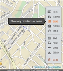
    If you already have a track or course with or without the points you just need to use Plotaroute.com.

    If you don't have a route you need create it first and than manually add your points.

    If you have a file with a course and/or waypoints you just need to upload it to Plotaroute.

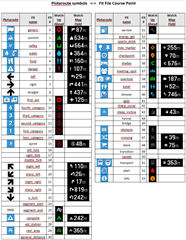
    After you need to adjust arrows and/or points icons according the table bellow and save it and download it as .fit file.

    You need to copy and past the file USING a CABLE to the watch folder Garmin/Newfiles. DO NOT send it wirelesses or Garmin Connect will mess all things up.


  • Thanks a lot. I will try. Are you aware of any solution how to transfer fit file to Garmin watch (Fenix 7) using mobile phone? I will be several months thru-hiking just with mobile and watch, I will have courses ready in my phone, so no problem to sync using Garmin Connect. However Up Ahead points, which I am going to update on the way (actual water sources, ad hoc closures) needs to be added using third party apps (like Locus). There is a feature on Garmin connect to update course, but very poorly implemented. It doesn't work unfortunatelly on Garmin Explore, course, updated by waypoints, doesn't show them as Up Ahead points on the watch.

  • Locus map has a Garmin plugin and a CIQ app. If you install both, you can send the course directly from the app to your watch. If you use another method to create your course, you can use the gimporter CIQ widget and companion android app to transfer the fit file to the watch.

    Both methods only work if you have a network connection on the phone. 

  • I can confirm, that Locus android app knows to embed point into route, which displays then in Garmin watch as up ahead point. It must be however new point, usual waypoints cannot be converted. At least I haven't found the way yet. This is essential for me when thru-hiking so I spent quite a lot of time to find solution. Seems to me, that nowadays outdoor devices and applications are rather focused on shorter workouts where you can do the preparation home.

  • Thanks a lot. I will try. Are you aware of any solution how to transfer fit file to Garmin watch (Fenix 7) using mobile phone? I will be several months thru-hiking just with mobile and watch, I will have courses ready in my phone, so no problem to sync using Garmin Connect. However Up Ahead points, which I am going to update on the way (actual water sources, ad hoc closures) needs to be added using third party apps (like Locus). There is a feature on Garmin connect to update course, but very poorly implemented. It doesn't work unfortunatelly on Garmin Explore, course, updated by waypoints, doesn't show them as Up Ahead points on the watch.

    If you have an Android phone, you can use gimporter on the watch and GPX/FIT exporter on the phone to transfer files. I use that routinely for transferring plotaroute files [disclaimer: I wrote the library that converts the route to the fit file containing waypoints & turn alerts] on download. 
    I've never tried using it for routes previously loaded on the phone for when you don't have signal. I'll have a poke at that to see, no obvious reason it wouldn't work.