Fenix 6 as GUIDE in town

Former Member
Former Member

Hello.

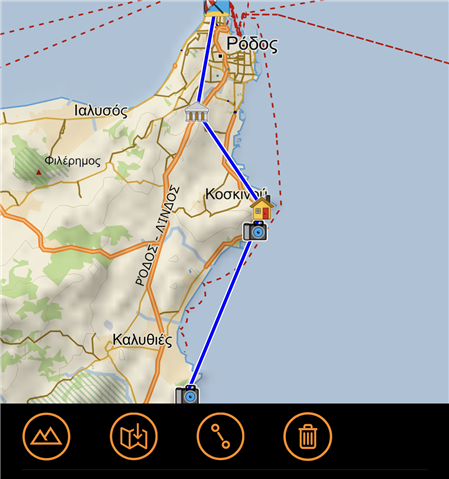
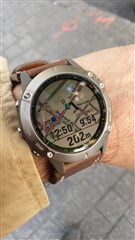
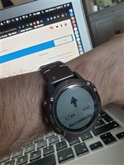
Does anyone use this clock as guide in towns?

I mean:

I could make a route which what I want to see in a town (for example Rome).
Send route to fenix and it automatically could calculate the route and lead me through all points with a shortest way.

And also, during a trip I could remove some points on route by phone and again update my route on fenix. 

  • i use it for walking....

    create a course in garmin connect web and send it to the watch.

    import a gpx is also possible....

    i start a walking activity and select the course on the watch.  it gives you turn by turn notifications...

  • Former Member
    0 Former Member over 5 years ago in reply to Dntom

    Yea but, it's hard to change my route through web while walking :(

  • I've wrote this in another post:

    The easiest way to get user waypoints with turn by turn navigation is to create a track in Garmin Explore.

    Important thing is to ONLY mark your waypoints in order you want to go to them and DO NOT TRY to route to them, just straight lines. Sync it with a Fenix (it works offline on a phone).

    Now in navigation settings on Fenix select routing > courses > use map. In that setting Fenix will take your track and route it on your map with turn by turn navigation taking to consideration all routing settings - is it a hike, bike, by popularity etc.

    I have a custom screen with distance and time to next waypoint and the same to the finish off all the waypoints. It only shows waypoints that you mark in Explore.

    You can edit that track live in Garmin Explore. All offline. Fenix is syncing with your Phone via Bluetooth.

    It looks like this:

  • You can also try more "primitive" approach. Slight smile You can use one of connect IQ apps called GRouteLoader or Sendpoints, which allow you to define and save custom point of interest (gps coordinates or address) on smart phone and transfer it to Fenix. Your points of interest are saved on Fenix under Saved Locations, under menu Navigate. You can define and name multiple locations, then start action Navigate, scroll to Saved Locations, select one of saved destinations and select Go To. Fenix will navigate you to selected location, then you simply select another POI under Saved Locations and continue with navigation through town.

  • Hello, I use it a lot, especially when I got my hands full of equipment or bags.

    Of course you can do route on it and even upload them but I use it more for fast retrieving my car or any address in a foreign city. It is a back up to my smartphone but also a great way to get navigation in harsh environments.

    The best example is in Brussels, a city I love but which is still stranger to me, the old city under the pouring rain at night. Even if my Samsung phone is waterproof, the screen is useless under the rain. The Fenix ergonomy doesn't mind about being wet.


    I have set Navigation to guide me turn by turn but I also favor "Navigate" inside the Walking activity just to point me the direction and the distance. It has also an ETA and ETE which are accurate.
    I have been able to find my car very fast (and for my job, fast is a good thing) and move it to another place where I could again pin point my position for future guidance.

    My best app for any trip is the use of the application "Sendpoints". It is purely wonderful to get any address quick inside your Fenix.

    https://apps.garmin.com/fr-FR/apps/93712e86-cec9-48c3-b18e-2a87aefead91


  • one of idea from another corner is also to set direction in Google maps on phone. Then lock screen, put phone in pocket and Garmin will show you notification.

    It is not map on Garmin, but you will see "in 300 meters turn right into Garminstreet", or "turn right to Garmin street now", etc.

    if you "miss" your way, Google maps will recalculate and adopt to new street.

    Yes and better ! There is the "Maps Nav" application which launched automatically once the Google Navigation has been launched.
    It show you not only notification but distance and arrows. It is very handy but less practical than see the map. :-)


    Here is the link from this very clever navigation tool:
    https://apps.garmin.com/en-US/apps/ac9022d5-274b-4515-a1e5-1c2164c05202