Using course with custom course points, without Turn-By-Turn

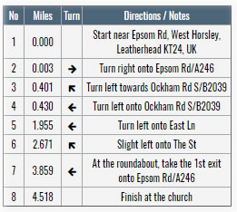
I know this has been discussed and I've tried to use previous threads instructions unsuccessfully.

My current attempt:

  1. Create track (Basecamp)
  2. Upload to Garmin Connect
  3. Add Course points
  4. Download as fit from garmin connect (This is what I read should work)
  5. Put in NewFiles folder on the watch using USB connection

When I follow the instructions above and start "Do Course" my next waypoint shown doesn't have a label and is 30 meters away whereas the custom point should be a few kilometers away and have a label.

I'm assuming the waypoint that don't have label is Course Points that Garmin Connect adds for Turn by Turn.

Is there a way to make this work with certainty??

Thanks!

  • Sorry if it sounded like I'm calling you confused :) I just meant that you were mixing the concepts of navigation for routes and tracks. Maybe I got it wrong.

    Anyway, in reference to what you wrote:

    1. The large number of blue pins you're seeing is because you're trying to use the "Use map" on a track which means your watch assumes each point on the track is a waypoint and actually tries to navigate between each of those (which makes no sense ofcourse because their very very close to each other) . This is the representation of waypoints in a route on the watch.

    2. Those "simpler turns icons/alerts" are being counted for as course points and will show in the "Next Waypoint" view, which is the core issue we're raising

  • But I'm not using a track, just a route ('Course') created by Garmin Connect between 2 points, so I don't know where the blue pins are coming from.

    If I just wanted straight line navigation between a limited number of waypoints, I would just use Garmin Explorer to make the route.

    Some of the confusion here seems to be in the definitions of 'course', 'course points' and 'Turn by Turn' in the thread title, I think. Not that Garmin makes it any easier to understand ... but on the watch TBT seems to refer strictly to the calculated directions with map overlays that you only get through 'Use Map'.

  • Additionally, since the device is not calculating the route in real time, you will not have built-in TBT, that's why Garmin Connect generates these course points on the server and adds them to the course, which is what some of us would love to be able to disable.

    All you wrote is clear but I do not understand why Connect have to create course points and not simple track points. 

    With my Edge 1000 I had followed tracks created using BaseCamp and the device did not have on the maps any kind of waypoint or course point if not created by me. 

    Also with Garmin Connect was the same but recently seems that something changed because some users with Edge 1000 have the same issue we are talking about but if they load from Connect tracks created in the past the issue is not present. 

  • For Garmin a route is a file with only the main point you want to pass through. If you select only start point and end point the file will have only two points and the device will navigate from one to the other ones. 

    So, Connect have to Generate a track and not a route if you want to follow the same way you see on Garmin Connect. Otherwise the way you see in Connect and the way you will navigate in your Garmin could be different because the device will recalculate the way using its map datas. 

  • The problem here is that when you send a course from GC to the device, it includes a whole bunch of automatic course points for all the turns, not just your custom course points.  There used to be a workaround for this where it wouldn't include all these extraneous course points if you downloaded to your computer, and then copied from there to your watch.  This is what Hesher is referring to in his original description.

    This "work around" isn't currently working as even downloading straight to the computer is including these automatic course points.  I've contacted Garmin to ask about this.  Hopefully this is something that they will fix soon.

  • I've done this by editing the course in a 3rd party tool. I've used plotaroute.com, but there's probably other editors that are able to this.

    You can create the course in Garmin Connect (or Basecamp for that matter) and then export it + import it at plotaroute.com for further editing. You can also create the course from scratch at plotaroute.com. Either or works.

    The trick is that at plotaroute.com you can display (and manually edit) all the turn-by-turn directions in a table that will look something like this: https://static.plotaroute.com/images/Posts/FewerDirections.jpg

    You can then edit/delete all the turn by turn directions and manually insert custom course points like "Summit", "Aid station" or whatever you like.

    Export the course and put it in the NewFiles folder on the watch using USB.

    When you load the course, you should now see the distance and label of the next custom course point - and not the next turn 30 meters away.

    You will still be able to view the course on the map on the watch, but you won't be able to get turn by turn directions. This is the trade off one has to make since both the turn by turn directions and the custom course points reside in the same table and the watch just shows the distance to the next one regardless of it's type. You can of course also do a compromise and leave in a few crucial turn by turn directions and delete all the more or less pointless ones.

    I don't normally use this method as I often need turn by turn directions, but my plan is to use this at longer trail races where the course is clearly marked. In this scenario, I don't need the turn by turn directions, but I'm interested in knowing the distance/time to/name of the next aid station or summit.

  • You will still be able to view the course on the map on the watch, but you won't be able to get turn by turn directions

    But is not normal that you have to decide it. 

    In the past was not like now and you can have turn by turn and distance to the next point at the same time. 

    After edited by Plotaroute and import manually did you used "use map" or "follow course" under the routing settings of the activity? 

    If you create the same track on BaseCamp as a track or as a route what happens in this two cases? Could you do a test about it? 

    GC is creating a track or a route? Because in the second case this will ad another problem about maximum course point. 

    Hopefully this is something that they will fix soon

    This is an issue that affect a lot of Garmin devices because is caused by GC. I will send an e-mail to Edge, Forerunner and Outdoor beta developer teams. 

    Could be useful if somebody else will do the same.

    [email protected]
    [email protected]
    [email protected]

  • After edited by Plotaroute and import manually did you used "use map" or "follow course" under the routing settings of the activity? 

    This is how a think about the options use map and follow course:

    • If I want to follow a route exactly as I created it or if I want to be in control of tbt and other course points, then I use follow course. File need to have a lot of gps points to have your exact way to go.
    • If I want the watch to calculate the way between specific points that you draw on map, then 'use map'. Ususally this is then just a few gps points in file with straight lines in between. Watch creates tbt as you run.
  • Very intersting, I send a mail to Garmin for the same issue. I want TbT AND view the "next distance" to MY user defined waypoint, not to the next turn ! Is it possible to Garmin to filter waypoint and show "next waypoint" only if it is a user defined waypoint ?