Navigation questions

Hello all:

New happy user here. Totally new to Garmin world, so some questions follows

I have some questions about navigation. For some reason I can't attach the pictures, so I'll just give a link

  1. How to set correct popular maps on watch. Routes was set to running, walking for RUN mode. During the run I switched to popular maps and courses colored blue were from cycling (only paved courses) and not from running and walking (dirt and single-tracks
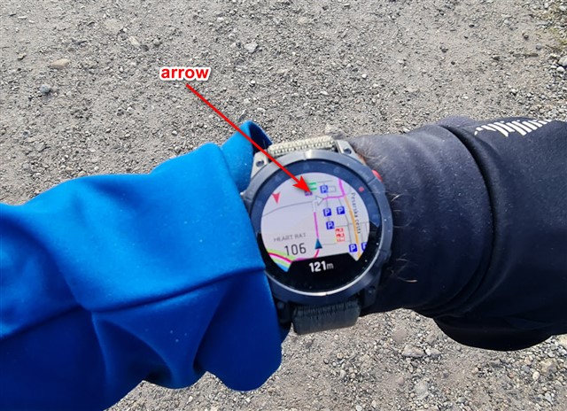
  2. When using popular maps, the visible routes are the same color as the current route used for navigation, it is almost impossible to recognize my entered route for navigation.
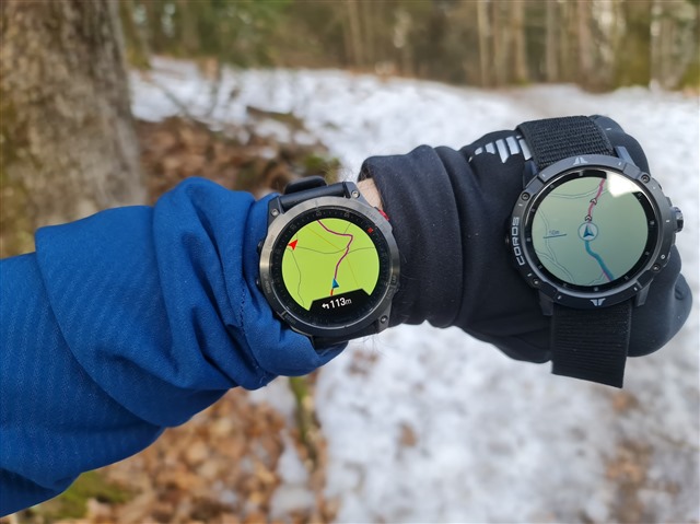
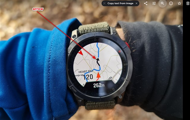
  3. Why navigation behaves differently if the route is transmited via garmin connect than if route is created on the watch (navigaton to point to interests- cities) Arrows for navigation are visible only if navigation is created on watch. I miss the thicky marked arrows when route is created on garmin connect.

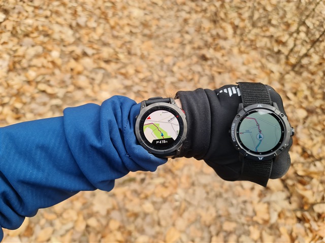
route created on the watch

route created on GC. epix on the left

  • What you initiate on the watch is actual nagivation. i.e. the watch is calculating the path from where you are to destination using its installed map, including recalculations in case you part from the calculated path.

    The other case is following a precalculated course, ie. there is no route calculation performed on the watch (but you can enable it to happen also in that case, setting follow course vs. follow map IIRC).

    In general navigation is somwehat underwhelming in general on Garmin watches, like most other feature as well. I hope you didn't switch from you chronos in the assumption you would have better navigation.

  • Can you please elaborate where this setting exactly is ?

    Does it mean that you can calculate a course on the watch from a garmin connect transfered file? Or you mean the opposite (no routing (with the big white arrows) on a course created on the watch?

  • In the activity navigation settings you can choose either "use map" or "follow course". In the case of "use map" it would do the actual routing on the watch and display that arrow overlayed on top of the route. But the routing mode uses significantly more battery and doesn't guarantee that the watch would stick to the original course. In contrast, the "follow course" mode ignores the on-device map altogether. Any navigation cues that it shows at the bottom of the map are all pre-calculated in advance in Garmin Connect and are sometimes excessive, inaccurate, or even misleading. For example, in you picture above it shows a left turn in 113 meters, but there isn't actually a left turn - it is just the trail itself bending left sharply. That is very typical because GC turn directions are based solely on the course shape rather than actual turns.

    When you initiate navigation on the watch it always uses the routing mode. 

  • Thank you, I understand now.

    I thought that was the opposite "use map" is not a very clear indication of what the watch will do.

    We have to understand "use map" as "calculate the course on the map".

    I tried, it works. I was pleasantly surprised by the time it took (one minute and 10 seconds for a 120  miles bicycle course)

    Perfect (I didn't follow the course, but it seems ok looking at the map)

  • So does Follow Course use more battery than Use Map? I have a preloaded course with waypoints for a race coming up to let me know ETA, etc. but I want you conserve as much battery as possible. It’s set to Follow Course.  

    From what I understand, GPS will use the installed map and track where you are on it (ie, off course, etc), but if I use the Map Setting, Garmin is trying to calculate on the fly my location and where I may be going based on POI/Popularity routing, etc based on its preloaded maps. Is my assessment correct? Thanks. 

  • I also often have the problem that the track calculated by the clock is not displayed, especially if the return route is the same as the outward route, then you just see the red marker of the route.

    At some point, the purple navigation line appears, but this is - compared to the Fenix 6 - much thinner and harder to see.

  • n the activity navigation settings you can choose either "use map" or "follow course". In the case of "use map" it would do the actual routing on the watch and display that arrow overlayed on top of the route

    Could you please tell me, where to find this? I am using german language and i found a setting, but it is named quite differently than I would translate it and I would like to know if I am in the right place.

  • I changed this setting during a trail run, and totally ignored my course (Trying to work out how to change the track color)

    To change to use map while in an activity:(eg Trail run)

    Hold Down the Up Button > Trail Run Settings > Routing > Courses.

    Can change from Follow Course to Use Map

  • I have a similar question. Can the breadcrumb color be changed? Red on pink/purple isn’t very visible. I’d like the traveled track to be blue and the navigation to stay pink/purple. Just need more contrast without changing the map themes which are useless to see where I’ve been. 

    Also @silentvoyager does using “follow course with waypoints” showing Distance to Next or ETA to Next on the map use more battery than just “following the course”? I have waypoints set up showing me how far to the next waypoint and time of arrival. I only went 6 miles and it use 42% battery on a full charge on Normal Power Setting. I turned off the display and everything else but HR and GPS (No Glonass or Galileo). It did help with battery, but just wondering b/c I don’t remember it using that much last year when I used Follow Course with waypoints (but I did have display and everything else off from the start). I have “Guide Me” option OFF but wondering if it gets enable with different Data Screens on the Maps are used. I’ve heard using the map data screen will use more battery than if you don’t have it on. Curious. 

  • Also @silentvoyager does using “follow course with waypoints” showing Distance to Next or ETA to Next on the map use more battery than just “following the course”? I have waypoints set up showing me how far to the next waypoint and time of arrival. I only went 6 miles and it use 42% battery on a full charge on Normal Power Setting.

    42% in 6 miles is definitely not normal. I haven't yet used course points on Fenix 7X, but with Fenix 6X I didn't notice any significant additional battery usage. I used navigation with course points for all aid stations in my last 100 miler last summer. That was almost 31 hour of continuous usage, and the battery usage was only slightly higher than normal.