EDGE All in One

IQ Store Link                                                        IQ Store Link

New device: EDGE 1050 !

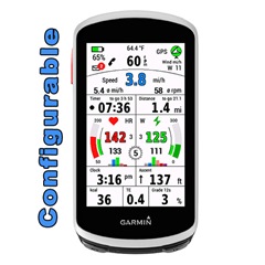
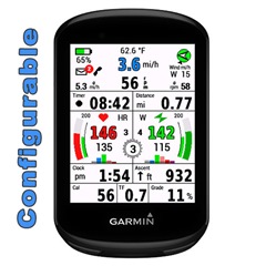
EDGE All in One is a single data field.
One for Edge 1030, 1040 and 1050, the other for Edge 530 and 830, 540, 840 and Explore2

It displays many values for cycling - around the most important values: speed, cadence, heart rate and power.

A detailed description can be found here:

EDGE 1030 + 1040 (English and Deutsch and French):  
mcinner.at/.../GuideAllinOne_E.pdf  
mcinner.at/.../GuideAllinOne_D.pdf
http://mcinner.at/files/GuideAllinOne_F.pdf

EDGE 530, 830, 540, 840 and Explore2:
mcinner.at/.../GuideAllinOne58.pdf

This datafield is free of charge, but if you like it and use it, it would be nice to be invited to a beer: paypal.me/AndreasWirth

I have tested the datafield intensively with my devices Edge 1030 and 1030 PLUS, 1040 and 530.

Download and install EdgeAllinOne as single datafield following these steps on your device:

Activity profile - Data Screens - Add New - Custom Data - Choose single layout
In the ConnectIQ collection select EdgeAllinOne1.

After installing this datafield on your device, various settings can be made. This is best done with Garmin Express or Garmin Connect Mobile. Instructions for this can be found here:

https://forums.garmin.com/developer/connect-iq/w/wiki/14/changing-connect-iq-app-settings

To use the power section, a power meter must be connected to the device and the values of the individual power zones must be stored in the settings.

For the heartrate graphs the heartrate zones are taken from your profile. It is therefore necessary that the zones are set in your device!

For the display of wind bearing and wind force, as well as the outdoor temperature, the data of a nearby weather station must be available via Garmin Connect Mobile. The app must therefore be loaded on the phone (but it can work in the background).

If you have questions or requests please write here and tell for which device!

  • I‘m on vacation. I will think about it…

  • Agreed +1. The calories burned isn't that important of a field, and it's pretty inaccurate if I recall. But agreed that Distance to go and ETA are more valuable than Cals burned.

  • I‘ve looked at the layout and have seen: it might be difficult to set ETA and Dist to Desti to Cal and TE fields, because they are small fields…

    btw: what speed base is relevant for calculating ETA when it comes to competitions/races?

  • - what device are you using?

  • That's agood point. And good question: there's a few algorithms for calculating ETA.  The obvious one is take the current average speed and use that combines with distance remaining to get ETA.

    So ETA = Distance remaining / average speed.

    A more sophisticated algorithm would do the same calculation but the speed would be modified in some manner. Either adjusting speed based on the elevation and grade of remaining path to destination, since 20 km on flat road probably takes less time to bike than 20 km over hilly mountain terrain. 

    Even better would be to use the elevation and also any headwind or tailwind component to adjust the estimated speed.

    Or you could personalize the speed based on that user's past average speeds or even that users past average speeds for that particular segment of road on the path to the destination. 

  • So ETA = Distance remaining / average speed.

    You know, that ETA based on average speed and Distance to Destination are available already on that datafield…?

  • Hello, Using an Edge 1050, there is a curved line above the Time and Distance values. It has a thick section located on different parts of the curve with or without a bright orange (?) dot. What does the thick part of the curve represent? What does the dot represent? 

    Thanks,

    Galen

  • If you have enabled „show sun events“ in the settings, then the curved line behalves as you describe:
    the curved line from left to right represents 24 hours of the day. The thick blue line shows the time from sunrise to sunset. The orange dot represents the current position of the sun.

    The exact time of sunrise and sunset is shown, when you tap the GPS rose. 

    1. Now, that's genius. I love it! And it is a great example of a COIK (acronym for Clear Only if Known). And can't believe how obvious it is once known.