apps.garmin.com/.../c6f0c049-3404-4264-8a31-8a81d7c7b041

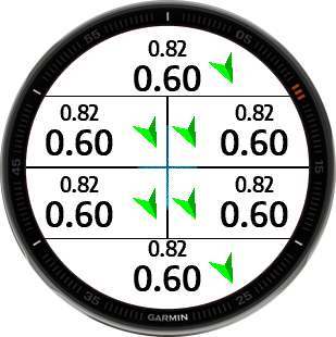
One data field that include: distance (along the route), distance to start (in a straight line) and arrow showing direction to start.
Data field provides orientation and helps to navigate to start also save place on data screen combining it's data with standard distance.
Going for trip in unknown terrain? Skiing in large area? Just add PSX-2 data field to the data screen, start activity and observe arrow that will lead to start (with information about distance to start).
Colours:
- shape (GPS quality): grey: not available, red: last known, pink: poor, blue:usable, green: good
- background (activity state): yellow paused, orange stopped
Shapes: circle (no activity, no GPS, no direction), arrow (when no circle :))
See also my other apps: apps.garmin.com/.../apps
