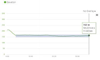
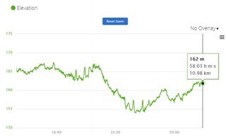
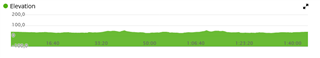
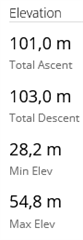
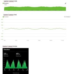
So this has been an issue for over 8 years.
Posts on the user forum won't have much effect on the development plans of Garmin. When requesting a feature, use rather the right tool designed for exactly that purpose: https://www.garmin.com/forms/ideas/ Unless it is frequently requested, it is unlikely Garmin would change it.
And you can do like I did too, and turn on the Y-scaling by selection, yourself with the help of GCOverrides:
There are already a number of threads about the scaling of the elevation chart in GC Web. Some of them are 10 years old, but the problem still exists.
You can zoom in by clicking and dragging across the chart to select the area of interest.
For me it's not possible to change the scaling. When I try to zoom in and drag in x-direction, the scaling in y-direction does not change. Or have I overlooked something?
The ordinate of the elevation chart is not scaled correctly. In my case, according GC web stats the minimum elevation 28.2m and the maximum elevation 54.8m. However, the elevation in the chart is scaled from -100m to +200m and therefore the elevation is nearly a straight line.
[EDIT]
And why is the scaling of the elevation chart accurate in GC Mobile and not in GC Web?
The scaling of the elevation graph in Garmin Connect Web is way too coarse. The scaling in Garmin Connect Mobile, on the other hand, is appropriate.
Users have been complaining about this problem for 12+ years. There are many threads in this forum and most threads are locked, e.g.
....
Why are all these threads locked even though the problem still exists?
Why doesn't Garmin correct this problem in GC Web as it is in GC Mobile?
Moderator: subra, joined all threads and unlocked.