This discussion has been locked.
You can no longer post new replies to this discussion. If you have a question you can start a new discussion

Routing onto Unpaved Roads when set to avoid

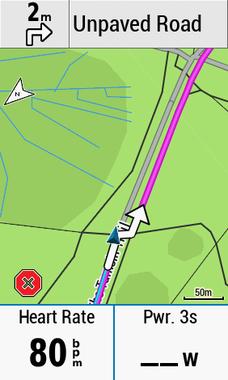
I'm seeing my 1030 increasingly trying to route me onto unsuitable roads when it's in Road Bike mode and is set to avoid unpaved roads. It does this whether I set it to popularity routing or not. The screenshot is from the road through Richmond Park in Surrey, the road is one of the most popular cycling routes in the world and is part of the route ridden by 20,000+ cyclists every year in the RideLondon Surrey 100. I don;t understand why my Garmin is trying to take me off the tarmac and onto the unpaved road.

I'm on Firmware 5 and 2018 maps.

Is anyone else seeing this? ciq.forums.garmin.com/.../1366434.jpg
  • I think what you are seeing here is what I call the s "shortcut problem".


    Interesting and I've certainly seen that but I don't think this is the same issue, as I was navigating to a point rather than following a course.
  • I agree. But if the person asking doesn't know what to look for then some help can be justified.

    People talking about an issue with a location should know about some way of providing specific information about that location (rather than being vague). I (and you) have no problem looking at the OSM data (we just have to know more-precisely what to look at). Providing the location on Google Maps would have been sufficient.

    I posted trying to shorten this thread, so everybody could locate the issue quickly, hopefully reduced the OP's frustration directed at the wrong place a bit and perhaps educated a few more people.

    Pointing out that people need to be more specific about indicating locations is part of "educating a few more people" too.

  • Interesting and I've certainly seen that but I don't think this is the same issue, as I was navigating to a point rather than following a course.


    It doesn't matter whether you are following a course or not. The problem is just more apparent when it happens when following a course.

    People wouldn't normally know it picked the "wrong" road because when they aren't following a course. In your case, you know it picked the "wrong" road because of your expectation it wouldn't be using unpaved roads (otherwise, you'd have no idea that it picked the "wrong" road).

    It appears the deviation off the road is the shorter path.

    Routers basically work by determining points and then finding the shortest route between them. The "avoidances" stuff works by virtually "deleting" the roads with the characteristics you don't want.

    If the roads/ways were tagged as "unpaved" in the Garmin map on the device and "avoid unpaved" was being uses, the unit should not have used the unpaved road. Ideally, the unit should display unpaved roads in an obvious way.

    When you are using a course, the unit doesn't use the "avoidances" settings. The course is supposed indicate the roads you want to use and including avoidances would cause the unit to "second guess" your choices (which would be really bad).
  • I dug into popularity routing a bit more, and I think somethings gone a bit screwy in Garmins implementation. Taking the road from Richmond Gate to Kingston gate in Richmond Park as a target (remember it's one of the most popular routes around with 1.5 million tracks on Strava), I tried mapping in various engines. Obviously the 1030 doesn't seem to take the logical route but all the other mapping engines take the logical route from Richmond Gate to Kingston Gate except Garmin Connect, unless you choose Google Maps and turn off popularity routing.

    I set the start point at the roundabout near Richmond Gate and the end point the roundabout near Kingston gate and let the mapping engine decide the best route. Spoiler alert, Popularity routing didn't choose the most popular route.

    Garmin Connect with Popularity Using Google (weird routing)
    The routing engine ignores the direct (and most popular route) and takes you back out of the park and a very roundabout route
    https://connect.garmin.com/modern/course/19260325

    Garmin Connect using OSM (weird routing)
    Same weird route, doesn't matter if popularity is on or off
    https://connect.garmin.com/modern/course/19260386

    Garmin Connect using Google with popularity off (looks correct)
    https://connect.garmin.com/modern/course/19260278

    Cycle Streets (looks correct)
    https://www.cyclestreets.net/journey/61192452/#balanced

    Strava (looks correct)
    https://www.strava.com/routes/13981561

    Ride WIth GPS (Looks correct)
    https://ridewithgps.com/routes/27889435

    Google Maps
    https://www.google.co.uk/maps/dir/51.4497749,-0.2953772/51.421796,-0.2860665/@51.435141,-0.2798981,15z/data=!4m2!4m1!3e1

    I therefore think somethings seriously broken in popularity routing
  • It appears the deviation off the road is the shorter path.

    Routers basically work by determining points and then finding the shortest route between them. The "avoidances" stuff works by virtually "deleting" the roads with the characteristics you don't want.


    In my experience my 1030 very rarely takes the shortest route, and if you see my previous post you'll see that Garmin Connect course creator doesn't either.

    If you try creating the route I did in GC, with OSM and Popularity on, try getting it to route on the main road (Queens Road) by adding additional points and you can see just how hard Garmin tries to stay off it, you really have to force it to take the logical route.
  • I therefore think somethings seriously broken in popularity routing


    There are issues with the routing data.

    If you look at the road from the roundabout from Sawyer's Hill to Queens Road, you'll see in the following that the oneway arrow is wrong.

    https://ridewithgps.com/routes/27889655


    Popularity routing won't override going the wrong way.


  • Which one way arrow? The ones I can see look correct (we drive on the left in the UK), although i see your route has taken a different direction to mine taking a slightly off road route, not sure why that is.
  • In my experience my 1030 very rarely takes the shortest route, and if you see my previous post you'll see that Garmin Connect course creator doesn't either.


    There's always some part of the "route creation" process that uses the shortest route between "waypoints". There's a difference between determining waypoints (places the course/route "must" pass through and what routes are chosen between waypoints.

    When you are using avoidances, the roads with properties that you are avoiding, as far as the router knows, don't exist (so they can't be used).

    There are additional constraints. The basic one is that the roads/ways have to connect. The router also won't lead create routes the wrong way.

    That is, the basic process of creating a route is (first) determining waypoints and (second) connecting them using the shortest route taking constraints into account.

    If you try creating the route I did in GC, with OSM and Popularity on, try getting it to route on the main road (Queens Road) by adding additional points and you can see just how hard Garmin tries to stay off it, you really have to force it to take the logical route.

    The "popularity" stuff likely is used to pick waypoints (more or less).
  • Which one way arrow?

    The one in my link (obviously).

    The ones I can see look correct (we drive on the left in the UK), although i see your route has taken a different direction to mine taking a slightly off road route, not sure why that is.

    There's something funny with the routing data.

    There are two sets of data being uses: (1) the stuff you see and (2) the routing data (which is what the route calculator uses). Usually, these two sets of data match but they don't always.

    Garmin Connect with Popularity Using Google (weird routing)
    The routing engine ignores the direct (and most popular route) and takes you back out of the park and a very roundabout route
    https://connect.garmin.com/modern/course/19260325

    If you look closely at the blue route line in this link, you should see that it doesn't follow the roads that closely. The blue line is created using the routing data, which isn't the same as the image you are seeing.

    I therefore think somethings seriously broken in popularity routing

    The problem is with the routing data (these are using either different routing data or different versions of the routing data).

    It appears the latest routing data in OSM is correct. Someday, the problem will go away.
  • The one in my link (obviously).


    All the arrows are correct in Ride with GPS

    ciq.forums.garmin.com/.../1367087.png