TLDR at the bottom – I usually don’t write a lot, but this issue is kind of disappointing considering it affects a “premium” watch. I have been watching the forums for the past few weeks since the 14.13/14.15 update and I haven’t seen a single post about this issue so not sure if it is affecting anyone else.
The Issue:
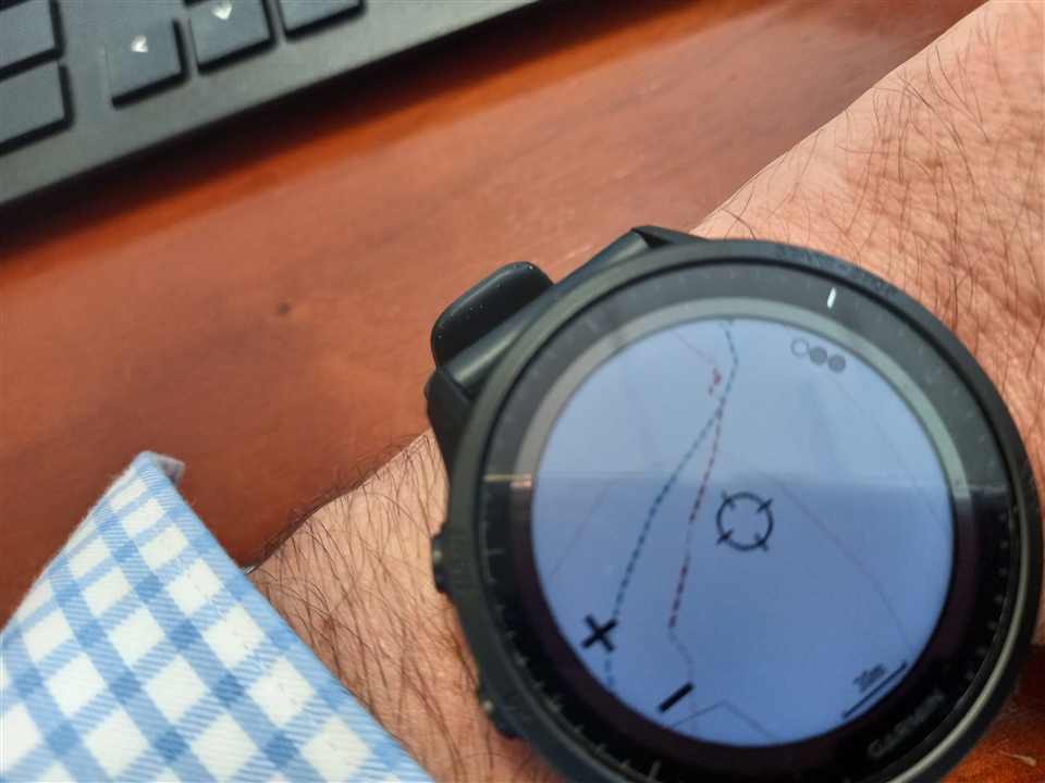
I use the maps almost daily while trail running and I like to glance down at the map to see what trails are nearby. It used to be super easy to clearly see all the nearby trails with a quick glance while running. After the 14.13 update (and then 14.15 update like a week later) about half the trails are a different size/width. This makes them harder to see and makes them easier to confuse with topo lines at a quick glance. See below for examples:
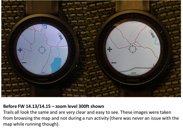
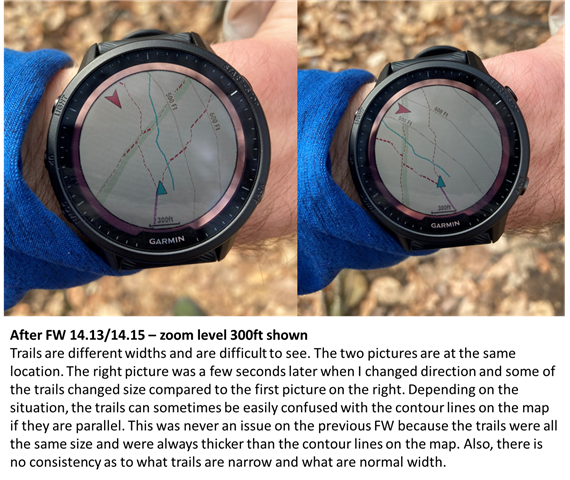
As you can see, in the older FW, all the trails were the same size/width and it was really easy to distinguish between trails, roads, and topo lines. After FW14.13/14.15, about half the trails are a different size/width, and their smaller size makes them hard to see and can also make them look like topo lines in some situations (if there is a trail parallel to a topo line). In addition to being an issue on the map data screen of a run activity, this issue is also present when browsing the map in the Map activity.
The trails also seem to change size based on direction of travel. As I am running, I noticed that if I change directions some of the trails become thinner and some of the trails revert back to normal. This makes it even more disorienting because it seems like you are looking at a different map each time you glance down at your watch.
Another interesting change I noticed is that before FW 14.13, at the beginning of each run the map screen would be zoomed out. I would need to manually zoom in to the 300ft level (which I typically use while trail running). After FW 14.13, the map is already zoomed to the 300ft level at the start of each activity. So this change seems to be correlated with the map issue. I have always had Auto Zoom disabled.
Garmin’s Response:
I contacted Garmin support about the issue and I was surprised when they simply said:
“It looks like this is not a bug and actually a feature of the watch now. I will add you to a case in which people do not like it”
How is this a feature? It makes it way more difficult to use the maps while running. If this truly is an intentional feature 1) how is it even helpful and 2) can it at least be optional?
Same Issue on Fenix 7 Several Months Ago:
I also used a Fenix 7s Solar Sapphire back in November/December 2022 and it also had this same exact issue. I even posted about it on the Fenix forum and compared it to the F955 Solar (link to the Fenix 7 forum post here: https://forums.garmin.com/outdoor-recreation/outdoor-recreation/f/fenix-7-series/316336/inconsistent-trail-size-on-fenix-7-map-compared-to-the-955). I had been in contact with Garmin support via email and since the issue could not be resolved, I decided to return the F7s and keep the F955 solely based on the fact that the map was better on the F955. They said they were unable to replicate the issue, but at least they never called it a "feature."
As stated above, the first time I noticed the issue on the F955 Solar, I also noticed that each time I started a run, the map screen was already zoomed into the 300ft level. This is the same behavior that the F7s had when I experienced the issue on that watch (Auto Zoom was always disabled on both watches). When I was originally testing the F955 and F7s in November/December, I always had to zoom into the map at the start of each run for the F955, but not for the F7s. The F955 never had any quality issues at that time, and the F7s had this map issue during every run.
F955 Solar - Current Map Settings:
Settings (for the Run activity):
Configure Maps: All available maps are enabled, except for the CourseView (golf maps). The SkiView maps are also enabled
Map Theme: High Contrast
Use Sys. Settings: Off
Orientation: Track Up
User Locations: Show
Auto Zoom: Off
Lock on Road: Off
Track Log: Show
Track Color: Magenta
Detail: High
Marine: Whatever the default settings were, I try to stay on the trails while running and not end up in the water so I don't use these maps
Draw Segments: Off
Draw Contours: On
Other Notes: I don’t typically use route/course navigation. I usually just have the map as a data screen so I can see what trails are nearby while running.
Steps Taken:
I did not change any settings between FW updates.
I plug in my watch to my computer and sync with Garmin Express after each run. So my maps are up to date (TopoActive NA 2022.20).
Back when I had the F7s, I reinstalled all the maps. I also tested out different map settings (Map Theme, Detail, etc.) for the F7s and F955 (older FW) and under each scenario the F7s always had the issue while the F955 (older FW) never had the issue. I was never able to resolve the issue on the F7s.
TLDR:
Trails on map after FW14.13/14.15 are inconsistent sizes/widths. The trails often change widths as I change direction while running, making it difficult and annoying to use the maps. Garmin says this bug is now a feature (?), but I also experienced this issue with the Fenix 7s SS several months ago.
Hopefully I provided enough information. Next time you go for a run/hike/walk/bike, add the map as a data screen and find some trails. I am curious if I am the only person experiencing this bug (or annoying feature).