This discussion has been locked.
You can no longer post new replies to this discussion. If you have a question you can start a new discussion

Elevation detection worse with the latest version

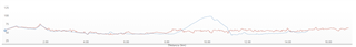
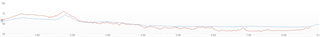
I was comparing two runs on the same route, the red one recorded with software 18.23 and the blue one with software 17.26.

beyond the difference in elevation they give (error of 3/4 meters, not important) you can clearly see that the blue line is much nicer and representative of reality, much more linear and constant. Whereas the red is discontinuous and I can assure you that I was running practically flat.

the only differences I can think of are that in the red run it was blowing much more wind and I was in short sleeves (uncovered watch) while in the blue run it was probably covered by the sleeves (although I cannot be sure).

The barometer is set to auto calibration

Is it a software problem or not? 

  • altimeter/barometer works by pressure changes, so if watch was uncovered plus it was strong wind, perfectly possible it impacted sensor. you can always correct your elevation plot in GC web, it's called elevation correction or similar. these things happen to me on other garmin model too so wouldn't call it specific model and software issue

  • comparing 2 other runs (the red with 18.23 and the blue with 18.20) I see the same thing. up to km 6 the course is the same, then it splits but it is not important the value but how much the homogeneity of the curve.
    the red with 18.23 is very discontinuous, in both I was in short sleeves and the wind was comparable.